Walker Basin facts for kids
Quick facts for kids Walker Basin |
|
|---|---|

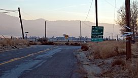
South view of Caliente Bodfish/Walser roads intersection in the basin
|
|
| Floor elevation | 3,376 ft (1,029 m) |
| Area | 10–11 square miles (26–28 km2) |
| Geography | |
| Location | California, United States |
| District | Kern County |
| Borders on | Breckenridge Mountain (west); Piute Mountain (northeast) |
The Walker Basin is a beautiful valley found in the southern part of the Sierra Nevada mountains. It is located in Kern County, California. This area was named after Joseph Reddeford Walker, who was an important explorer and pioneer in this region.
Exploring Walker Basin's Location
The Walker Basin is situated in a key area of California. You can find it south of Lake Isabella and the Kern River Valley. It is also east of the city of Bakersfield. To the north, it is close to Tehachapi Pass. The basin is also near the southern edge of the Sequoia National Forest.
The valley is surrounded by tall mountains. To the west, you will see Breckenridge Mountain, which stands at about 7,548 feet (2,301 m) high. On the east side, you will find Piute Mountain. The community of Havilah is located north of the basin, up a canyon. If you travel south over a ridge, you will reach the communities of Fig Orchard and Millersville.


