Wallingford Center, Connecticut facts for kids
Quick facts for kids
Wallingford Center, Connecticut
|
|
|---|---|
 |
|
| Country | |
| State | Connecticut |
| County | New Haven |
| Town | Wallingford |
| Area | |
| • Total | 19.11 km2 (7.38 sq mi) |
| • Land | 18.80 km2 (7.26 sq mi) |
| • Water | 0.31 km2 (0.12 sq mi) |
| Elevation | 45 m (148 ft) |
| Population
(2010)
|
|
| • Total | 18,209 |
| • Density | 968.6/km2 (2,509/sq mi) |
| Time zone | UTC-5 (Eastern (EST)) |
| • Summer (DST) | UTC-4 (EDT) |
| ZIP Code |
06492 (Wallingford)
|
| Area code(s) | 203/475 |
| FIPS code | 09-78880 |
| GNIS feature ID | 2377875 |
Wallingford Center is a special community in Connecticut, United States. It's known as a census-designated place (CDP). This means it's an area that the government counts for population, but it's not a separate town or city by itself. Wallingford Center is the main part of the larger town of Wallingford.
About Wallingford Center
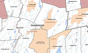
Wallingford Center is located in the central and southern parts of the town of Wallingford. It's in New Haven County.
Where is Wallingford Center?
You can find Wallingford Center bordered by some major roads. To the west, you'll see the Wilbur Cross Parkway. To the east, there's Interstate 91. The community also touches the town of North Haven to the south.
The northern part of Wallingford Center stretches across different streets. These include New Rock Hill Road, Durham Road, Christian Street, North Elm Street, and Maplewood Avenue. It goes up North Main Street as far as Yale Avenue. Here, it crosses the Wilbur Cross Parkway.
U.S. Route 5, also known as Colony Street, is the main road that runs north and south through the community. North of Wallingford Center, you'll find the neighborhood of Yalesville.
How Many People Live There?
According to the 2010 census, about 18,209 people lived in Wallingford Center. This is a big part of the total population of the entire town of Wallingford, which was 45,135 people at that time.
See also
 In Spanish: Wallingford Center para niños
 | Stephanie Wilson |
 | Charles Bolden |
 | Ronald McNair |
 | Frederick D. Gregory |


