
Walthourville, Georgia facts for kids
Quick facts for kids
Walthourville, Georgia
|
|
|---|---|

City hall
|
|

Location in Liberty County and the state of Georgia
|
|
| Country | United States |
| State | Georgia |
| County | Liberty |
| Area | |
| • Total | 3.84 sq mi (9.96 km2) |
| • Land | 3.84 sq mi (9.96 km2) |
| • Water | 0.00 sq mi (0.00 km2) |
| Elevation | 89 ft (27 m) |
| Population
(2020)
|
|
| • Total | 3,680 |
| • Density | 957.34/sq mi (369.63/km2) |
| Time zone | UTC-5 (Eastern (EST)) |
| • Summer (DST) | UTC-4 (EDT) |
| ZIP code |
31333
|
| Area code(s) | 912 |
| FIPS code | 13-80256 |
| GNIS feature ID | 0356617 |
Walthourville is a city in Liberty County, Georgia, United States. It is pronounced like "wall-tower-vil." When it became an official city in 1974, its government was made up entirely of women. In 1978, Carrie Kent was elected mayor. She was the first African-American woman mayor in Georgia's history. Walthourville is part of the larger Hinesville-Fort Stewart area. In 2020, about 3,680 people lived there.
Contents
A Look at Walthourville's Past

Walthourville is named after Andrew Walthour. He was a soldier and doctor who started a large farm, called a plantation, around 1795.
The Walthourville Presbyterian Church has a long history. The first building, built in 1820, was used by both Baptists and Presbyterians. A new Presbyterian church was built in 1845, but it burned down in 1877. Another church was finished in 1878, but a storm destroyed it in 1881. The church building you see today was completed in 1884.
The Walthourville Academy was a school for both boys and girls. It was founded in 1823. A post office opened in the town on July 3, 1837. By the 1840s, Walthourville was one of the most successful towns in south Georgia.
In 1857, railroad tracks reached Walthourville. The train station was the fourth one built on the line from Savannah. In 1862, a guide described Walthourville as the "largest place in the county." It had about 400 people and two good schools.
The All-Woman Government
By 1974, Walthourville had an airstrip and an industrial park. People worried that the nearby city of Hinesville, Georgia might take over the area. Even though Walthourville was 179 years old, it wasn't officially a city by the state. Men in the town had tried to make it official 12 years earlier, but they couldn't agree.
A group of women decided to try. They gathered information about the town's population and collected 300 signatures. They sent the paperwork to the Georgia General Assembly, which is like the state's law-making group. They named themselves the temporary leaders. They thought it was "just on paper." But when the papers came back approved by Governor Jimmy Carter, they realized they had to serve as the town's government until the first election.

These women were sworn into office in April 1974. They became one of the first all-woman city governments in Georgia's history. This happened during a time when women's rights were a big topic. The all-woman government in Walthourville got a lot of attention. News groups like A.P., UPI, and even NBC Nightly News and CBS Evening News covered their story. However, the women of Walthourville said they were not "women's libbers." They just wanted to help their town.
In December 1974, the all-woman group ran for election. A group of men also ran against them, but none of the men won. The women showed they were good at campaigning and governing. They had streetlights put up and street signs installed. They didn't raise any new taxes. They even gave their own small salaries back to the town.
Four years later, in the 1978 election, one man did join the council. In the same election, council member Carrie Kent was elected mayor. She made history as the first African-American woman to be elected mayor in Georgia. In 2007, the town put up a historical marker to remember the story of its official beginning.
Places to Visit
Near Walthourville, you can find Tea Grove Plantation. It's an outdoor place with old buildings, vehicles, and farm tools. You can visit and see what life was like long ago.
The Walthourville Presbyterian Church is also a special place. It is listed on the National Register of Historic Places because of its importance to history.
Where is Walthourville?
Walthourville is located at coordinates 31.776124 degrees North and -81.624229 degrees West.
The city covers a total area of about 3.8 square miles (9.8 square kilometers). All of this area is land.
People of Walthourville
| Historical population | |||
|---|---|---|---|
| Census | Pop. | %± | |
| 1980 | 905 | — | |
| 1990 | 2,024 | 123.6% | |
| 2000 | 4,030 | 99.1% | |
| 2010 | 4,111 | 2.0% | |
| 2020 | 3,680 | −10.5% | |
| U.S. Decennial Census | |||
In 2020, the 2020 United States census counted 3,680 people living in Walthourville. There were 1,652 households and 1,006 families.
Here's a look at the different groups of people living in Walthourville in 2020:
| Race | Number of People | Percentage |
|---|---|---|
| White (not Hispanic) | 879 | 23.89% |
| Black or African American (not Hispanic) | 2,103 | 57.15% |
| Native American | 15 | 0.41% |
| Asian | 32 | 0.87% |
| Pacific Islander | 24 | 0.65% |
| Other/Mixed | 248 | 6.74% |
| Hispanic or Latino | 379 | 10.3% |
Schools in Walthourville
The Liberty County School District is in charge of the public schools that serve students in Walthourville.
Famous People from Walthourville
- William Bennett Fleming (1803 – 1886), a U.S. Representative who retired here.
- Patrick Hues Mell (1814 – 1888), a president of the Southern Baptist Convention and chancellor of the University of Georgia.
- Robert Walthour (1878 – 1949), a World Champion cyclist.
Images for kids
-
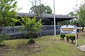
The building housing the police station and the post office
-
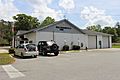
Fire station
-
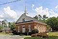
Walthourville Baptist Church
-
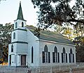
Walthourville Presbyterian Church (on the National Register of Historic Places)


See also
 In Spanish: Walthourville para niños
