Walworth, Wisconsin facts for kids
Quick facts for kids
Walworth, Wisconsin
|
|
|---|---|

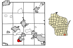
Location of Walworth in Walworth County, Wisconsin.
|
|
| Country | |
| State | |
| County | Walworth |
| Area | |
| • Total | 1.72 sq mi (4.46 km2) |
| • Land | 1.72 sq mi (4.46 km2) |
| • Water | 0.00 sq mi (0.00 km2) |
| Elevation | 1,004 ft (306 m) |
| Population
(2020)
|
|
| • Total | 2,759 |
| • Density | 1,641.70/sq mi (633.86/km2) |
| Time zone | UTC-6 (Central (CST)) |
| • Summer (DST) | UTC-5 (CDT) |
| ZIP Code |
53184
|
| Area code(s) | 262 |
| FIPS code | 55-83275 |
| GNIS feature ID | 1576186 |
Walworth is a village located in Walworth County, Wisconsin, in the United States. In 2020, about 2,759 people lived there. The village is part of the larger Town of Walworth.
Contents
Exploring Walworth's Location
Walworth is found at these coordinates: 42°31′54″N 88°35′35″W / 42.53167°N 88.59306°W. The village covers about 1.54 square miles (4 square kilometers) of land.
Main Roads in Walworth
- Beloit Street
- US Highway 14: This important road is known as Madison Street north of the town square. South of the town square, it's called S. Main Street.
- Wisconsin Highway 67: This highway meets Kenosha Street from the north. Locally, it's called Kenosha Street and South Main Street. It continues west as Highway 67 where it meets US 14 and Lakeville Road.
Walworth's Population Over Time
| Historical population | |||
|---|---|---|---|
| Census | Pop. | %± | |
| 1910 | 755 | — | |
| 1920 | 757 | 0.3% | |
| 1930 | 920 | 21.5% | |
| 1940 | 875 | −4.9% | |
| 1950 | 1,137 | 29.9% | |
| 1960 | 1,494 | 31.4% | |
| 1970 | 1,637 | 9.6% | |
| 1980 | 1,607 | −1.8% | |
| 1990 | 1,614 | 0.4% | |
| 2000 | 2,304 | 42.8% | |
| 2010 | 2,816 | 22.2% | |
| 2020 | 2,759 | −2.0% | |
| U.S. Decennial Census | |||
What the 2010 Census Showed
In 2010, the census counted 2,816 people living in Walworth. There were 1,068 households, which are groups of people living together. About 700 of these were families.
The village had about 1,828 people per square mile (706 people per square kilometer). There were 1,172 housing units, like houses or apartments.
Most residents (87.5%) were White. Other groups included African American (0.7%), Native American (0.1%), and Asian (0.8%). About 9.5% were from other races, and 1.2% were from two or more races. People of Hispanic or Latino background made up 17.8% of the population.
Out of the 1,068 households, 37.1% had children under 18 living with them. Almost half (49.5%) were married couples. About 11.1% had a female head of household without a husband. And 4.9% had a male head of household without a wife.
The average household had 2.58 people. The average family had 3.22 people.
The average age in the village was 36.1 years old. About 28.4% of residents were under 18. About 14.9% were 65 years old or older. Slightly more than half (51.9%) of the population was female, and 48.1% was male.
Schools in Walworth
Walworth has two public schools for students.
- Walworth Joint School District 1 runs Walworth Elementary. This school teaches students from Pre-Kindergarten up to 8th grade. It has about 575 students.
- Big Foot High School serves students in grades 9–12. About 468 students attend this high school. They come from Walworth and nearby villages like Fontana and Sharon. Students also come from the townships of Walworth, Delavan, Linn, and Sharon.
Local Businesses and Industry
Walworth is home to the first American factory for Kikkoman. This factory opened in 1972. Kikkoman is a famous Japanese company. It was the first Japanese company to open a factory in the United States.
Getting Around Walworth: Transportation
Walworth used to be the end of the line for the Milwaukee Road's northern commuter train service. This train service was cut back to Fox Lake, Illinois in 1982. This happened when Metra took over the train route.
The old Walworth station platform and the track used for turning trains around are still there. However, they are not used anymore for passenger trains. The Wisconsin and Southern Railroad still operates a daily freight train that passes through Walworth.
Images for kids
See also
 In Spanish: Walworth (Wisconsin) para niños
 | Selma Burke |
 | Pauline Powell Burns |
 | Frederick J. Brown |
 | Robert Blackburn |


