Wanbi, South Australia facts for kids
Quick facts for kids WanbiSouth Australia |
|||||||||||||||
|---|---|---|---|---|---|---|---|---|---|---|---|---|---|---|---|
| Established | 9 July 1914 (town) 11 November 1999 (locality) |
||||||||||||||
| Postcode(s) | 5310 | ||||||||||||||
| Time zone | ACST (UTC+9:30) | ||||||||||||||
| • Summer (DST) | ACDT (UTC+10:30) | ||||||||||||||
| Location |
|
||||||||||||||
| LGA(s) | District Council of Karoonda East Murray | ||||||||||||||
| Region | Murray and Mallee | ||||||||||||||
| County | Albert | ||||||||||||||
| State electorate(s) | Hammond | ||||||||||||||
| Federal Division(s) | Barker | ||||||||||||||
|
|||||||||||||||
|
|||||||||||||||
| Footnotes | Locations Adjoining localities |
||||||||||||||
Wanbi is a small township in the Australian state of South Australia. It is located on the Karoonda Highway, about 160 kilometers (100 miles) east of Adelaide, the state capital. Wanbi is also about 56 kilometers (35 miles) north-east of Karoonda.
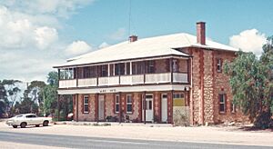
The town is built on a ridge covered by mallee trees. It has a simple layout with just one main street. In 1932, a hotel was built in Wanbi. At that time, the town was growing. It had a general store, a cream depot, and several homes. Many of these homes were for people who worked for the South Australian Railways.
The Story of Wanbi's Railway
The land around Wanbi has sandy soil. This soil was not good for farming. Because of this, people were not very interested in settling there. The state government had a plan. They decided to build a railway first to help open up the Mallee area for settlement.
Early Railway Days
The Wanbi railway station was built in 1912. It was part of a wide railway line that went to Paringa. About 13 years later, Wanbi became a junction. This happened when the Yinkanie branchline was opened.
With the new branch line, Wanbi became a busier place. It helped serve the communities along the branch line. It also supported the railway workers.
Changes and Closures
In the mid-1960s, things started to change. Companies in Moorook stopped sending their citrus fruit by train from Yinkanie. This meant a lot less freight was moved through Wanbi.
Trains still carried grain, fertilizer, and some other goods until 1971. That year, the branch line finally closed. In 1996, the main railway line through Wanbi was changed. It was updated to a standard gauge line, which is a different width. This line went towards Loxton. However, in 2015, this main line also closed down.
 | Victor J. Glover |
 | Yvonne Cagle |
 | Jeanette Epps |
 | Bernard A. Harris Jr. |


