
Wanblee, South Dakota facts for kids
Quick facts for kids
Wanblee, South Dakota
Waŋblí Hoȟpi
|
|
|---|---|
 |
|

Location in Jackson County and the state of South Dakota
|
|
| Country | United States |
| State | South Dakota |
| County | Jackson |
| Government | |
| • Type | Tribal |
| Area | |
| • Total | 2.02 sq mi (5.23 km2) |
| • Land | 2.01 sq mi (5.21 km2) |
| • Water | 0.01 sq mi (0.02 km2) |
| Elevation | 2,635 ft (803 m) |
| Population
(2020)
|
|
| • Total | 674 |
| • Density | 334.82/sq mi (129.25/km2) |
| Time zone | UTC-7 (Mountain (MST)) |
| • Summer (DST) | UTC-6 (MDT) |
| ZIP code |
57577
|
| Area code(s) | 605 |
| FIPS code | 46-68580 |
| GNIS feature ID | 2393836 |
Wanblee is a small community in Jackson County, South Dakota, United States. It is located on the Pine Ridge Indian Reservation. The name "Wanblee" comes from the Lakota language words Waŋblí Hoȟpi, which means "Golden Eagle Nest". This name was chosen because the town is close to a place called Wanbli hohpi paha, or Eagle Nest Butte.
According to the 2020 United States Census, 674 people live in Wanblee. Most of these residents are members of the Oglala band of Lakota Sioux. Wanblee is also known for being very remote. It is just a few miles northeast of the North American continental pole of inaccessibility, which is a spot on land that is farthest from any ocean coast.
In 1992, parts of the movie Thunderheart were filmed in Wanblee. The town was shown as an unnamed place on a made-up reservation called Bear Creek. However, in real life, it was filmed on the Pine Ridge Indian Reservation.
Contents
Exploring Wanblee's Geography
Wanblee is located in the southern part of Jackson County, South Dakota. South Dakota Highway 44 runs through the community. This highway connects Wanblee to other towns. For example, it leads east about 47 miles to White River, South Dakota. It also goes northwest about 28 miles to Interior, South Dakota. Another nearby town is Kadoka, South Dakota, which is about 28 miles northeast if you take Highways 44 and 73.
The United States Census Bureau says that Wanblee covers a total area of about 2.02 square miles (5.23 square kilometers). Most of this area is land, about 2.01 square miles (5.21 square kilometers). Only a very small part, about 0.01 square miles (0.02 square kilometers), is water. Craven Creek flows through the western side of Wanblee. This creek eventually leads north to the White River.
-
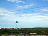
Wanblee, South Dakota, showing the town's water tower and some homes

Understanding Wanblee's Population
| Historical population | |||
|---|---|---|---|
| Census | Pop. | %± | |
| 2020 | 674 | — | |
| U.S. Decennial Census | |||
A census is an official count of the population. The most recent count in 2020 showed that 674 people live in Wanblee. Back in 2000, there were 641 people living there. At that time, there were 132 households, which are groups of people living together. Out of these, 107 were families.
Who Lives in Wanblee?
In 2000, almost all the people in Wanblee were Native American, making up about 97.19% of the population. A smaller number, 2.34%, were White. About 0.47% of the people were from two or more different racial backgrounds.
Many households in Wanblee had children. About 50.8% of households had children under 18 living with them. About 32.6% of households were married couples living together. Some households had a female head of the house without a husband present, making up 35.6%. About 18.9% of households were not families. The average household had about 4.86 people, and the average family had about 5.35 people.
Age Groups in Wanblee
The population in Wanblee is quite young. In 2000, about 47.6% of the people were under 18 years old. About 12.5% were between 18 and 24 years old. People aged 25 to 44 made up 21.8% of the population. Those between 45 and 64 years old were 13.4%. Only 4.7% of the population was 65 years or older. The average age in Wanblee was 19 years old.
Income and Economic Situation
In 2000, about 68.9% of families and 72.3% of the total population lived below the poverty line. This included 72.9% of those under 18 and 86.2% of those 65 or older. The average income per person in Wanblee was $4,584. The average income for a household was $14,286, and for a family, it was $14,844.
See also
 In Spanish: Wanblee (Dakota del Sur) para niños
