
Ward Beach facts for kids
Quick facts for kids Ward Beach |
|
|---|---|

Ward Beach, where the Flaxbourne River flows into the sea
|
|

Location in New Zealand Marlborough
|
|
| Location | Marlborough, New Zealand |
| Coordinates | 41°50′42″S 174°11′00″E / 41.84500°S 174.18333°E |
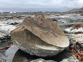
Ward Beach is a special part of the coast in the Marlborough Region of New Zealand. It's famous for its amazing and unusual rock formations. Some of these rocks were pushed up by more than 2 meters during the big 2016 Kaikōura earthquake. You can also find cool round rocks called the Ward Beach boulders here.
Just a bit north, about 1.5 kilometers from the end of the Ward Beach road, are the Chancet Rocks. This area is a scientific reserve. These rocks have rare trace fossils (marks left by ancient animals). They also show some of the best evidence on land of a huge event that happened long ago, marking the end of the age of dinosaurs.
For over 40 years, a local company used Ward Beach to launch their boats for catching crayfish. But after the 2016 earthquake, the beach changed. It became too hard and unsafe to launch boats from their usual spot. The company has been trying to find a new safe place, but many ideas have been stopped because they might harm endangered animals. To protect the area, vehicles are now not allowed in a special zone from the Ward Beach road end up to the Chancet Rocks.
Contents
Exploring Ward Beach: Location and Features
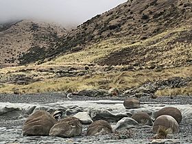
Ward Beach is on the southeast coast of Marlborough. It's about 4.7 kilometers southeast of the town of Ward. It's also about 75 kilometers northwest of Kaikōura. The Flaxbourne River flows into the Pacific Ocean at the southern end of Ward Beach.
This part of the coast, from The Needles in the south to Chancet Rocks in the north, is known for its unique limestone rocks. New Zealand has listed three important natural sites near Ward Beach:
- Flaxbourne River: Here you can see how rocks have folded and pushed together.
- Ward Beach: Famous for its round rocks and flat rock platforms.
- Chancet Rocks: This site shows the boundary between two major time periods in Earth's history.
You can get to Ward Beach by road from Ward town. The Marlborough District Council has made a small area for visitors to enjoy the beach for the day.
How the 2016 Earthquake Changed Ward Beach
The powerful Kaikōura earthquake in November 2016 caused the land at Ward Beach and Chancet Rocks to lift up. It rose by about 2.5 to 3 meters!
Right after the earthquake, the newly lifted rocks and reefs were covered with sea creatures. There were seaweed, crayfish, paua, and sea snails. They were all suddenly exposed above the high tide line.
The earthquake also made the Flaxbourne River change its path. It cut through its old riverbed and beach gravels, showing even more of the limestone rock underneath.
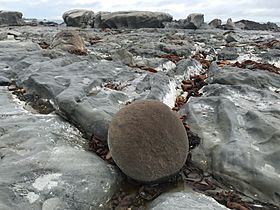
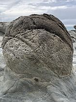
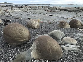
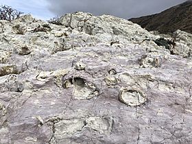
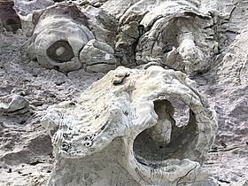
Ward Beach Boulders: Nature's Giant Marbles
41°50′31″S 174°11′18″E / 41.84194°S 174.18833°E The huge uplift of the seabed during the 2016 Kaikōura earthquake uncovered amazing round rocks at Ward Beach. These rocks are called concretions. They look a bit like the famous Moeraki Boulders found further south in New Zealand.
You can find these boulders about 800 meters north of the car park at Ward Beach. These round rocks formed deep in the ocean floor from marine sediments. This happened during the late Cretaceous period, more than 65 million years ago! They grew over millions of years inside mudstone. Concretions are much harder than the mudstone around them. This means they stay put even after the softer mudstone wears away. The Ward Beach boulders are made of dolomite, a type of rock.
- Ward Beach Boulders
-
-
-
-
-


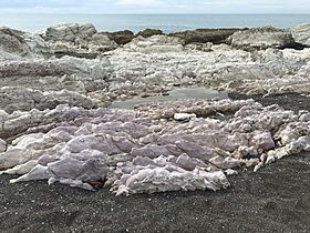
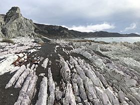
Chancet Rocks: A Window to the Past
41°50′07″S 174°11′47″E / 41.83528°S 174.19639°E
How Chancet Rocks Formed
The Chancet Rocks are limestone formations about 1.5 kilometers north of the Ward Beach road end. This area is a special scientific reserve.
The rocks are made of a fine, white limestone called Amuri limestone. It started as calcareous sediments that settled on the ocean floor. This happened between 65 and 25 million years ago.
These layers of limestone were once flat on the seabed. But over time, movements in the Earth's crust tilted them. Now they stand almost straight up! You can see large trace fossils in these rocks. These are marks left by ancient animals that scientists are still trying to identify.
The Dinosaur Extinction Layer at Chancet Rocks
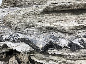
The Chancet Rocks show evidence of the Cretaceous–Paleogene boundary (K-Pg boundary). This is a layer found worldwide that marks a huge mass extinction event. This event included the end of the age of the dinosaurs! Scientists believe a giant asteroid hitting Earth (where Mexico's Yucatan Peninsula is today) caused this global event.
The K-Pg boundary layer at Chancet Rocks has high levels of iridium. This metal is often found in asteroids. The boundary layer usually sits between light pink limestone from the Late Cretaceous period and light green limestone from the Palaeogene period. The boundary itself is a dark grey limestone layer, about 20 centimeters thick. It has a very thin, dark grey clay layer (about 2 centimeters) right at the boundary.
Chancet Rocks is one of the best places on land in the Southern Hemisphere to see this important K-Pg boundary layer in ocean sediments.
Protecting Chancet Rocks
Chancet Rocks is a protected area owned by the government. It's a scientific reserve under the Reserves Act 1977. Its boundaries are officially recorded.
The NZ Royal Forest and Bird Protection Society said in 2017 that Chancet Rocks is "internationally significant." They also said it's "vulnerable to complete destruction by human activity."
Chancet Rocks and The Needles (south of Ward Beach) are both called "Outstanding Natural Character Areas." This means their unique limestone features and wave-cut platforms are very special to this coastline.
- Chancet Rocks
-
-
-
-
-


Wildlife at Ward Beach
The Marlborough Environment Plan says that the Ward Beach coastline is a beautiful natural area. It's also mapped as a threatened environment, meaning its plants and animals need protection.
Animals and birds found along this coast include:
- New Zealand fur seal
- Banded dotterel
- Ruddy turnstone
- Caspian tern
- Black-fronted tern
- White-fronted tern
- South Island oystercatcher
- Variable oystercatcher
- Pied stilt
Plants growing in the sand dunes here include:
- Morning glory, Calystegia soldanella
- Marlborough rock daisy, Pachystegia insignis
- New Zealand daphne, Pimelea prostrata
- Coastal tree daisy, Olearia solandri
- Tauhinu or cottonwood, Ozothamnus leptophyllus
Challenges for Fishing at Ward Beach
A local fishing company, Burkhart Fisheries, had used Ward Beach to launch their boats for 42 years. But the 2016 Kaikōura earthquake changed the seabed. It became very hard for them to launch their boat from their usual spot.
The company asked the Marlborough District Council for permission to launch their boat from a spot further north, near the Chancet Rocks scientific reserve. Their plan included making a road to the new launch site. However, people who cared about the environment were against this. They worried it would disturb animals and plants, including a group of New Zealand fur seals. They also worried that more people using the new road would damage the scientific reserve. After hearings in July 2017, the company's request was turned down.
Later, the Royal Forest and Bird Protection Society complained that the company used bulldozers to move their boats. In December 2017, the Environment Court ordered the company to stop. The orders created a special "exclusion zone" south of Chancet Rocks. This zone protects threatened birds like banded dotterels and variable oystercatchers that nest on the beach. These orders became permanent in June 2019.
In May 2018, the fishing company got permission to build a temporary gravel path for launching boats. This path was outside the exclusion zone.
In January 2020, Burkhart Fisheries asked for permission again to move gravel and fix a temporary launch path. This new spot was 50 meters south of the exclusion zone. Conservation groups and local Māori (iwi) were against it. In early 2021, Burkhart Fisheries was allowed to move gravel and create the temporary launch site for five years. However, they found that the sea kept pushing gravel into the launch site too quickly. The rules of their new permission limited how they could fix this problem.
