
Warrenton, Georgia facts for kids
Quick facts for kids
Warrenton, Georgia
|
|
|---|---|

Warren County Courthouse
|
|

Location in Warren County and the state of Georgia
|
|
| Country | United States |
| State | Georgia |
| County | Warren |
| Area | |
| • Total | 1.92 sq mi (4.98 km2) |
| • Land | 1.91 sq mi (4.94 km2) |
| • Water | 0.02 sq mi (0.04 km2) |
| Elevation | 518 ft (158 m) |
| Population
(2020)
|
|
| • Total | 1,744 |
| • Density | 914.53/sq mi (353.09/km2) |
| Time zone | UTC-5 (Eastern (EST)) |
| • Summer (DST) | UTC-4 (EDT) |
| ZIP code |
30828
|
| Area code(s) | 706 |
| FIPS code | 13-80592 |
| GNIS feature ID | 0333368 |
Warrenton is a city located in Georgia, United States. It is the main town, also known as the county seat, for Warren County. In 2020, about 1,744 people lived there.
Contents
History of Warrenton
Warrenton was started in 1797. It became the main town for Warren County, which was created in 1793. The town officially became a town in 1810. Later, in 1908, it was recognized as a city. The name Warrenton honors Joseph Warren, a general from the American Revolutionary War.
Geography and Location
Warrenton is located at 33°24′27″N 82°39′46″W / 33.40750°N 82.66278°W. This means it's in the northern part of Georgia. The city covers a total area of about 1.9 square miles (4.9 km2). Most of this area is land, with a very small part being water.
Warrenton's Climate
The weather in Warrenton changes throughout the year. It has warm summers and mild winters. You can see more details about the temperatures and rainfall in the table below.
| Climate data for Warrenton, Georgia, 1991–2020 normals, extremes 1914–2017 | |||||||||||||
|---|---|---|---|---|---|---|---|---|---|---|---|---|---|
| Month | Jan | Feb | Mar | Apr | May | Jun | Jul | Aug | Sep | Oct | Nov | Dec | Year |
| Record high °F (°C) | 86 (30) |
83 (28) |
90 (32) |
95 (35) |
100 (38) |
110 (43) |
109 (43) |
107 (42) |
108 (42) |
99 (37) |
90 (32) |
80 (27) |
110 (43) |
| Mean maximum °F (°C) | 71.1 (21.7) |
75.3 (24.1) |
81.1 (27.3) |
86.3 (30.2) |
90.6 (32.6) |
95.8 (35.4) |
97.8 (36.6) |
96.9 (36.1) |
92.5 (33.6) |
85.7 (29.8) |
79.7 (26.5) |
73.2 (22.9) |
99.2 (37.3) |
| Mean daily maximum °F (°C) | 56.2 (13.4) |
59.4 (15.2) |
67.1 (19.5) |
75.0 (23.9) |
82.2 (27.9) |
88.0 (31.1) |
91.2 (32.9) |
89.5 (31.9) |
84.4 (29.1) |
75.3 (24.1) |
65.9 (18.8) |
58.1 (14.5) |
74.4 (23.5) |
| Daily mean °F (°C) | 44.7 (7.1) |
47.4 (8.6) |
54.1 (12.3) |
61.6 (16.4) |
69.6 (20.9) |
76.6 (24.8) |
80.2 (26.8) |
78.8 (26.0) |
73.3 (22.9) |
63.0 (17.2) |
53.0 (11.7) |
46.7 (8.2) |
62.4 (16.9) |
| Mean daily minimum °F (°C) | 33.1 (0.6) |
35.4 (1.9) |
41.1 (5.1) |
48.3 (9.1) |
57.1 (13.9) |
65.3 (18.5) |
69.1 (20.6) |
68.2 (20.1) |
62.2 (16.8) |
50.7 (10.4) |
40.1 (4.5) |
35.3 (1.8) |
50.5 (10.3) |
| Mean minimum °F (°C) | 16.4 (−8.7) |
20.9 (−6.2) |
25.6 (−3.6) |
33.1 (0.6) |
43.8 (6.6) |
56.1 (13.4) |
62.2 (16.8) |
60.5 (15.8) |
48.5 (9.2) |
35.1 (1.7) |
27.8 (−2.3) |
19.7 (−6.8) |
14.0 (−10.0) |
| Record low °F (°C) | −3 (−19) |
7 (−14) |
11 (−12) |
26 (−3) |
37 (3) |
40 (4) |
53 (12) |
52 (11) |
36 (2) |
26 (−3) |
9 (−13) |
5 (−15) |
−3 (−19) |
| Average precipitation inches (mm) | 4.47 (114) |
4.21 (107) |
4.94 (125) |
3.04 (77) |
3.07 (78) |
4.04 (103) |
3.94 (100) |
4.59 (117) |
3.97 (101) |
3.42 (87) |
3.38 (86) |
3.93 (100) |
47 (1,195) |
| Average precipitation days (≥ 0.01 in) | 7.5 | 6.9 | 6.8 | 5.7 | 6.0 | 6.8 | 7.1 | 7.3 | 5.0 | 4.8 | 5.4 | 6.8 | 76.1 |
| Source 1: NOAA | |||||||||||||
| Source 2: National Weather Service (mean maxima/minima, precip/precip days 1981–2010) | |||||||||||||
Population and People
The population of Warrenton has changed over the years. You can see how many people lived in the city during different census years in the table below.
| Historical population | |||
|---|---|---|---|
| Census | Pop. | %± | |
| 1880 | 1,022 | — | |
| 1890 | 974 | −4.7% | |
| 1900 | 1,113 | 14.3% | |
| 1910 | 1,368 | 22.9% | |
| 1920 | 1,407 | 2.9% | |
| 1930 | 1,289 | −8.4% | |
| 1940 | 1,284 | −0.4% | |
| 1950 | 1,442 | 12.3% | |
| 1960 | 1,770 | 22.7% | |
| 1970 | 2,073 | 17.1% | |
| 1980 | 2,172 | 4.8% | |
| 1990 | 2,056 | −5.3% | |
| 2000 | 2,013 | −2.1% | |
| 2010 | 1,937 | −3.8% | |
| 2020 | 1,744 | −10.0% | |
| U.S. Decennial Census 1850-1870 1870-1880 1890-1910 1920-1930 1940 1950 1960 1970 1980 1990 2000 2010 |
|||
Who Lives in Warrenton?
In 2020, the census counted 1,744 people living in Warrenton. These people made up 840 households and 528 families. The table below shows the different groups of people living in Warrenton.
| Race | Num. | Perc. |
|---|---|---|
| White (non-Hispanic) | 409 | 23.45% |
| Black or African American (non-Hispanic) | 1,276 | 73.17% |
| Native American | 2 | 0.11% |
| Asian | 10 | 0.57% |
| Other/Mixed | 35 | 2.01% |
| Hispanic or Latino | 12 | 0.69% |
Education in Warrenton
The schools in Warrenton are part of the Warren County School District. This district helps students from pre-school all the way to twelfth grade.
Warren County Schools
The Warren County School District has two main buildings. One building is for pre-kindergarten and kindergarten students. The other building is for students in grades 1 through 12. The district has about 70 full-time teachers. They teach over 894 students.
The schools in the district are:
- Freeman Elementary School
- Warren County Middle School
- Warren County High School
Images for kids
-
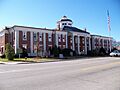
The Warren County Courthouse, a historic building in Warrenton.
See also
 In Spanish: Warrenton (Georgia) para niños
