Watino facts for kids
Quick facts for kids
Watino
|
|
|---|---|

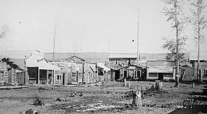
Watino, circa 1915
|
|
| Country | Canada |
| Province | Alberta |
| Region | Northern Alberta |
| Census division | 19 |
| Municipal district | Birch Hills County |
| Government | |
| • Type | Unincorporated |
| Population
(1991)
|
|
| • Total | 22 |
| Time zone | UTC−07:00 (MST) |
| • Summer (DST) | UTC−06:00 (MDT) |
| Area code(s) | 780, 587, 825 |
Watino is a small community called a hamlet in northern Alberta, Canada. It is part of Birch Hills County. You can find it on Highway 49, about 96 kilometers (60 miles) northeast of Grande Prairie. Watino is located at an elevation of 385 meters (1,263 feet) above sea level.
Contents
History of Watino
Watino was built on the banks of the Smoky River. It is located just downstream from where the Smoky River meets the Little Smoky River. The name "Watino" comes from a Cree word, "Wa-ye-te-naw," which means "valley."
Early Days and the Railway
In 1915, the Edmonton, Dunvegan and British Columbia Railway started building a railway bridge over the Smoky River. This led to two temporary communities popping up. On the east side of the river was the main railway camp, called Pruden's Crossing. On the west side, connected by a small cable ferry, was another community called Smoky River, or "Old Smoky."
The railway bridge was finished in 1916. A railway siding, which is a short track next to the main one, was built on the west bank. In 1917, Carl Donis opened the first post office here, also named Prudens Crossing. The community's name was changed to Watino in 1921. The post office officially changed its name to Watino in November 1925.
Growing Community
Over time, Watino grew into a busy place. It had a school, two grocery stores, and two hardware stores. There was also a post office, three machine agencies, a garage, and a grain elevator. A grain elevator is a tall building used to store grain. The community also had a restaurant, a pool hall, a community hall, and a skating rink.
The railway was very important for Watino. There was a railway station, a pump station, and a coal dock for the steam trains. There were also stockyards, which are pens for livestock. In 1920, the Egg Lake Ranch even shipped 13 carloads of cattle from here all the way to Chicago!
The railway was the main way to travel and transport goods until 1938. That year, a proper highway was built, replacing the old bush trail. A ferry was also set up to cross the Smoky River. In 1950, Watino saw a "boom" (a period of fast growth) when the Park Brothers sawmill and planer opened.
Changes Over Time
Watino started to get smaller in the 1970s and 1980s. In 1972, the Smoky River flooded. This flood washed away a lot of farmland in the valley. Then, in 1975, the grain elevator was removed. Another big flood in 1987 caused a lot of damage to the railway bridge. This flood forced the CNR train system to stop running through Watino.
Population Information
In the 1991 Census, which was done by Statistics Canada, Watino had a population of 22 people.
 | Tommie Smith |
 | Simone Manuel |
 | Shani Davis |
 | Simone Biles |
 | Alice Coachman |


