Wawayanda, New York facts for kids
Quick facts for kids
Wawayanda, New York
|
|
|---|---|
| Town of Wawayanda | |

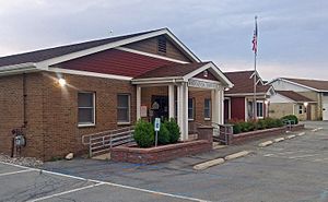
Town hall
|
|

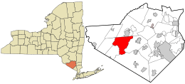
Location in Orange County and the state of New York.
|
|
| Country | United States |
| State | New York |
| County | Orange |
| Area | |
| • Total | 35.03 sq mi (90.72 km2) |
| • Land | 34.72 sq mi (89.92 km2) |
| • Water | 0.31 sq mi (0.80 km2) |
| Elevation | 558 ft (170 m) |
| Population
(2020)
|
|
| • Total | 7,534 |
| • Density | 216.99/sq mi (83.79/km2) |
| Time zone | UTC-5 (Eastern (EST)) |
| • Summer (DST) | UTC-4 (EDT) |
| FIPS code | 36-78839 |
| GNIS feature ID | 0979610 |
Wawayanda is a town located in Orange County, New York. It's a part of the United States. In 2020, about 7,534 people lived here. You can find Wawayanda in the western part of Orange County, just south of the city of Middletown.
Contents
History of Wawayanda: How the Town Began
The town of Wawayanda was created in 1849. It was formed from a larger town called Minisink. People first started settling in this area after the American Revolution.
The name "Wawayanda" was used for this region even before 1769. A map from that year shows how the land was divided. This division helped solve a long-running border dispute. It was known as the New York – New Jersey Line War, which lasted for 50 years!
Geography: Exploring Wawayanda's Location
Wawayanda covers a total area of about 35 square miles (90.7 square kilometers). Almost all of this area is land. Only a tiny part, about 0.1 square miles (0.8 square kilometers), is water.
Borders and Neighbors: Who is Around Wawayanda?
The town has many neighbors!
- To the north, it borders the city of Middletown and the town of Wallkill.
- The town of Goshen is to the east.
- To the south, you'll find the town of Warwick.
- The town of Minisink is to the southwest.
- To the west, it borders the town of Greenville.
- There's also a very short border with the town of Mount Hope to the northwest.
Major Roads: Getting Around Wawayanda
Several important highways pass through Wawayanda.
- Interstate 84 and U.S. Route 6 are key roads. They help people travel east and west. U.S. Route 6 is also known as the Grand Army of the Republic Highway.
- New York State Route 17M crosses the northern part of the town.
- New York State Route 284 is a highway that runs north and south.
Demographics: Who Lives in Wawayanda?
| Historical population | |||
|---|---|---|---|
| Census | Pop. | %± | |
| 1860 | 2,085 | — | |
| 1870 | 1,900 | −8.9% | |
| 1880 | 1,879 | −1.1% | |
| 1890 | 1,625 | −13.5% | |
| 1900 | 1,539 | −5.3% | |
| 1910 | 1,603 | 4.2% | |
| 1920 | 1,689 | 5.4% | |
| 1930 | 1,946 | 15.2% | |
| 1940 | 2,218 | 14.0% | |
| 1950 | 2,435 | 9.8% | |
| 1960 | 3,229 | 32.6% | |
| 1970 | 3,408 | 5.5% | |
| 1980 | 4,298 | 26.1% | |
| 1990 | 5,518 | 28.4% | |
| 2000 | 6,273 | 13.7% | |
| 2010 | 7,266 | 15.8% | |
| 2020 | 7,534 | 3.7% | |
| U.S. Decennial Census | |||
In 2010, the town's population was 7,266 people. Most residents, about 80.7%, were white. About 12.2% were Hispanic, 5.0% were African-American, and 1.9% were Asian. A small number, 0.2%, were Native American.
In 2000, there were 6,273 people living in Wawayanda. There were 2,095 households, which are groups of people living together. About 1,719 of these were families. The population density was about 179 people per square mile.
Households and Families: A Closer Look
Out of all the households in 2000:
- 43.2% had children under 18 living there.
- 68.7% were married couples living together.
- 9.5% had a female head of the household with no husband present.
- 17.9% were not families.
- About 14.6% of all households were made up of individuals living alone.
- 5.5% had someone 65 years or older living by themselves.
The average household had about 2.98 people. The average family had about 3.29 people.
Age and Income: What the Numbers Show
The population in Wawayanda was spread out by age in 2000:
- 29.5% were under 18 years old.
- 6.1% were between 18 and 24.
- 30.1% were between 25 and 44.
- 24.7% were between 45 and 64.
- 9.5% were 65 years or older.
The average age in the town was 37 years. For every 100 females, there were about 100.6 males.
The median income for a household was $61,885. For a family, the median income was $67,479. Males earned a median of $42,491, while females earned $27,993. The average income per person in the town was $21,856. About 3.7% of the population lived below the poverty line. This included 2.0% of those under 18 and 4.3% of those 65 or older.
Hamlets: Small Communities in Wawayanda
Wawayanda is home to several smaller communities called hamlets:
- Denton – This hamlet is near the eastern border of the town, located on NY 17M.
- Gardnerville – You can find Gardnerville on County Route 62 in the southern part of Wawayanda.
- Millsburgh – This hamlet is south of South Centerville, along County Route 22.
- New Hampton – Located on US 6, New Hampton is in the northeastern part of Wawayanda.
- Pellets Island – This area is right at the eastern border of the town.
- Ridgebury – Ridgebury is a hamlet found east of Slate Hill.
- Slate Hill – This hamlet is on US 6, close to the eastern town line.
- South Centerville – Located on US 6 at County Route 22, this hamlet is near the western border of the town.
Town Supervisors: Leaders of Wawayanda
The town supervisor is like the mayor of the town. Here are some of the people who have served as Wawayanda's town supervisor:
- Denise Quinn (2020-present), Republican
- John Razzano (2006–2020), Republican
- Wayne Skinner (2004–2006), Democrat
- Thomas Deblock (1996–2004), Republican
- Jeffrey K. Bridges Jr. (1992–1996), Republican
- Ed. Flynn (1988–1992), Democrat
- Brice "Buzzy" Flynn (1970–1988), Democrat
See also
 In Spanish: Wawayanda para niños


