Weatherby, Missouri facts for kids
Quick facts for kids
Weatherby, Missouri
|
|
|---|---|

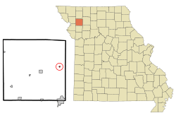
Location of Weatherby, Missouri
|
|
| Country | United States |
| State | Missouri |
| County | DeKalb |
| Area | |
| • Total | 0.12 sq mi (0.31 km2) |
| • Land | 0.12 sq mi (0.31 km2) |
| • Water | 0.00 sq mi (0.00 km2) |
| Elevation | 879 ft (268 m) |
| Population
(2020)
|
|
| • Total | 80 |
| • Density | 677.97/sq mi (261.41/km2) |
| Time zone | UTC-6 (Central (CST)) |
| • Summer (DST) | UTC-5 (CDT) |
| ZIP code |
64497
|
| Area code(s) | 816 |
| FIPS code | 29-78028 |
| GNIS feature ID | 2397728 |
Weatherby is a small village in DeKalb County, Missouri, in the United States. It is located in the eastern part of the county. In 2020, about 80 people lived there. Weatherby is part of the larger St. Joseph metropolitan area.
Contents
History of Weatherby
Weatherby was officially started in 1885. A person named L. H. Weatherby planned out the village, and it was named after him. A post office, which is where mail is handled, has been open in Weatherby since 1886.
A special building called the Absolom Riggs House is in Weatherby. It was added to the National Register of Historic Places in 1982. This means it's an important historical place in the United States.
Where is Weatherby?
Weatherby is located along Missouri Route 6. It is about six miles east of a town called Maysville. It's also two miles west of the line that divides DeKalb County and Daviess County. A stream called Grindstone Creek flows about a mile southeast of the village.
According to the United States Census Bureau, Weatherby is a very small place. It covers an area of about 0.31 square kilometers (or 0.12 square miles). All of this area is land, with no water.
Weatherby's Population
| Historical population | |||
|---|---|---|---|
| Census | Pop. | %± | |
| 1890 | 134 | — | |
| 1900 | 228 | 70.1% | |
| 1910 | 171 | −25.0% | |
| 1920 | 220 | 28.7% | |
| 1930 | 177 | −19.5% | |
| 1940 | 208 | 17.5% | |
| 1950 | 156 | −25.0% | |
| 1960 | 450 | 188.5% | |
| 1970 | 91 | −79.8% | |
| 1980 | 121 | 33.0% | |
| 1990 | 91 | −24.8% | |
| 2000 | 123 | 35.2% | |
| 2010 | 107 | −13.0% | |
| 2020 | 80 | −25.2% | |
| U.S. Decennial Census | |||
What the 2010 Census Showed
In 2010, a count of the population, called a census, showed that 107 people lived in Weatherby. There were 41 households, which are groups of people living in one home. Out of these, 28 were families. The village had about 891.7 people per square mile.
There were 58 housing units, which are places where people can live. Most people in the village (99.1%) were White. A small number (0.9%) were Native American.
About 36.6% of the households had children under 18 living there. About 41.5% were married couples living together. Some households (22.0%) had a female head of the house with no husband. A small number (4.9%) had a male head of the house with no wife. About 31.7% of households were not families.
About 22.0% of all households were just one person living alone. Only 7.3% had someone living alone who was 65 years old or older. On average, there were 2.61 people in each household. The average family had 3.04 people.
The average age of people in the village was 33.6 years old. About 26.2% of the people were under 18. About 9.2% were between 18 and 24. Another 26.1% were between 25 and 44. About 29.8% were between 45 and 64. Finally, 8.4% were 65 years old or older. Slightly more than half (51.4%) of the people were male, and 48.6% were female.
Religious Places in Weatherby
Weatherby is home to three monasteries. A monastery is a place where people, often monks or nuns, live a religious life. These three monasteries are:
- Protection of the Virgin Mary Monastery
- St. Xenia Sisterhood
- Holy Archangel Michael and All Angels Skete
All three of these religious communities are part of the Serbian Orthodox Church in North and South America.
See also
 In Spanish: Weatherby (Misuri) para niños
 | William M. Jackson |
 | Juan E. Gilbert |
 | Neil deGrasse Tyson |

