Wekweètì facts for kids
Quick facts for kids
Wekweètì
|
||
|---|---|---|
|
First Nation
|
||
 |
||
|
||
| Country | Canada | |
| Territory | Northwest Territories | |
| Region | North Slave | |
| Constituency | Monfwi | |
| Permanent community | 1962 | |
| Incorporated | 4 August 2005 | |
| Area | ||
| • Land | 14.70 km2 (5.68 sq mi) | |
| Elevation | 368 m (1,207 ft) | |
| Population
(2016)
|
||
| • Total | 129 | |
| • Density | 8.8/km2 (23/sq mi) | |
| Time zone | UTC−07:00 (MST) | |
| • Summer (DST) | UTC−06:00 (MDT) | |
| Canadian Postal code |
X0E 1W0
|
|
| Area code(s) | 867 | |
| Telephone exchange | 713 | |
| - Food price index | 144.8 | |
| Sources: Department of Municipal and Community Affairs, Prince of Wales Northern Heritage Centre, Canada Flight Supplement 2015 figure based on Yellowknife = 100 |
||
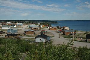
Wekweètì (pronounced "wek-WAY-tee") is a small community in the Northwest Territories, Canada. Its name comes from the Dogrib language and means "rock lakes." Officially, it's known as the Tłı̨chǫ Community Government of Wekweètì.
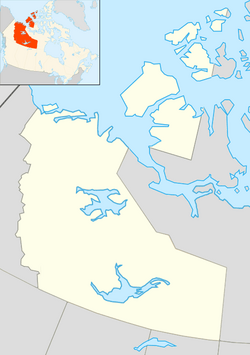
Wekweètì is home to the Tłı̨chǫ (Dogrib Dene) First Nation people. It is located about 195 kilometers (121 miles) north of Yellowknife. There are no roads that connect Wekweètì all year round. However, in winter, there is a special ice road that people can use. Most of the time, people travel to and from Wekweètì by flying into the Wekweètì Airport. This community is also the closest one to the Ekati Diamond Mine, which is near the border of Nunavut. Wekweètì is an important part of the Tlicho Government.
History of Wekweètì
The land around Wekweètì has always been important to the Tłı̨chǫ (Dogrib) First Nation. It was a popular place for hunting for many years. In the 1960s, elders from the Dene people near Behchokǫ̀ decided to go back to living on the land. They set up traditional camps in the wilderness. Wekweètì was started during this time.
Over the years, Wekweètì has grown into a modern community. It now has important services for its residents. Before November 1, 1998, the community was called Snare Lake. Then, until August 4, 2005, its name was spelled Wekweti.
Before 2005, the community was not officially set up as a town. It was run by a First Nations band government called Dechi Laot'i First Nations. After 2005, many of the responsibilities of Dechi Laot'i were given to the new Wekweètì Community Government. However, the Dechi Laot'i group is still recognized by the Canadian government for things like Indian Act enrollment.
Who Lives in Wekweètì?
The number of people living in Wekweètì changes over time. In the 2021 Census, there were 109 people living there. This was a small decrease from the 129 people counted in 2016. The community covers about 14.71 square kilometers (5.68 square miles) of land.
Most of the people in Wekweètì are First Nations. The main languages spoken are Dogrib and English.
Community Services
Wekweètì has several important services for its residents:
- Alexis Arrowmaker School: This is the elementary and junior high school in Wekweètì. It was rebuilt in 1994. The school is named after Alexis Arrowmaker, who was one of the people who signed Treaty 11.
- Hozila Naedik'e General Store: This is the community's local store where people can buy supplies.
- Wekweeti Hotel/Snare Lake Lodge: This is a small hotel or lodge with ten beds for visitors.
- Health Centre: The community has a health centre to provide medical care.
- Community Learning Centre: This center offers learning opportunities for people in the community.
- Wekweètì does not have a permanent Royal Canadian Mounted Police detachment.
Weather in Wekweètì
Wekweètì has a subarctic climate. This means it has mild to warm summers with cool nights. The winters are very long and extremely cold.
|
||||||||||||||||||||||||||||||||||||||||||||||||||||||||||||||||||||||||||||||||||||||||||||||||
 | Madam C. J. Walker |
 | Janet Emerson Bashen |
 | Annie Turnbo Malone |
 | Maggie L. Walker |


