Wellington, Maine facts for kids
Quick facts for kids
Wellington, Maine
|
|
|---|---|

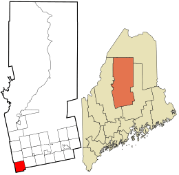
Location in Piscataquis County and the state of Maine.
|
|
| Country | United States |
| State | Maine |
| County | Piscataquis |
| Area | |
| • Total | 39.93 sq mi (103.42 km2) |
| • Land | 39.86 sq mi (103.24 km2) |
| • Water | 0.07 sq mi (0.18 km2) |
| Elevation | 735 ft (224 m) |
| Population
(2020)
|
|
| • Total | 229 |
| • Density | 6/sq mi (2.2/km2) |
| Time zone | UTC-5 (Eastern (EST)) |
| • Summer (DST) | UTC-4 (EDT) |
| ZIP Code |
04942
|
| Area code(s) | 207 |
| FIPS code | 23-81405 |
| GNIS feature ID | 0579056 |
Wellington is a small town located in Piscataquis County, Maine, in the United States. It was named after Arthur Wellesley, 1st Duke of Wellington, a famous British general and statesman. In 2020, the town had a population of 229 people.
Contents
Exploring Wellington's Location and Land
Wellington is found in the state of Maine. It is part of Piscataquis County. The town covers a total area of about 39.93 square miles (103.42 square kilometers).
Most of this area, about 39.86 square miles (103.24 square kilometers), is land. A very small part, about 0.07 square miles (0.18 square kilometers), is water. This means Wellington is mostly land-based.
Understanding Wellington's Population Changes
The number of people living in Wellington has changed over many years. Records show how the population has grown and shrunk since 1830.
How Many People Live in Wellington?
The population of Wellington was 229 people in 2020. This number comes from the 2020 United States Census.
| Historical population | |||
|---|---|---|---|
| Census | Pop. | %± | |
| 1830 | 639 | — | |
| 1840 | 722 | 13.0% | |
| 1850 | 600 | −16.9% | |
| 1860 | 694 | 15.7% | |
| 1870 | 681 | −1.9% | |
| 1880 | 647 | −5.0% | |
| 1890 | 584 | −9.7% | |
| 1900 | 413 | −29.3% | |
| 1910 | 393 | −4.8% | |
| 1920 | 459 | 16.8% | |
| 1930 | 350 | −23.7% | |
| 1940 | 261 | −25.4% | |
| 1950 | 252 | −3.4% | |
| 1960 | 231 | −8.3% | |
| 1970 | 232 | 0.4% | |
| 1980 | 287 | 23.7% | |
| 1990 | 270 | −5.9% | |
| 2000 | 258 | −4.4% | |
| 2010 | 260 | 0.8% | |
| 2020 | 229 | −11.9% | |
| U.S. Decennial Census | |||
A Look at the 2010 Census Data
In 2010, the town had 260 people living in 124 households. A household is a group of people living together. There were also 82 families. The town had about 6.5 people per square mile (2.5 people per square kilometer).
There were 278 housing units in Wellington. A housing unit is a house, apartment, or other place where people live. The average density was about 7.0 units per square mile (2.7 units per square kilometer).
Most of the people in Wellington were White (97.3%). A small number were Pacific Islander (1.9%) or from two or more races (0.8%).
Who Lives in Wellington's Households?
Out of the 124 households:
- 18.5% had children under 18 living there.
- 54.0% were married couples living together.
- 8.1% had a female head of the household with no husband.
- 4.0% had a male head of the household with no wife.
- 33.9% were non-families, meaning people living together who are not related.
About 31.5% of all households were made up of just one person. Also, 11.3% of households had someone aged 65 or older living alone. The average household had 2.10 people, and the average family had 2.54 people.
What is the Average Age in Wellington?
The average age of people in Wellington in 2010 was 50.3 years old.
- 15.4% of residents were under 18.
- 4.2% were between 18 and 24.
- 21.9% were between 25 and 44.
- 34.5% were between 45 and 64.
- 23.8% were 65 or older.
The town had an equal number of males and females, with 50.0% male and 50.0% female residents.
See also
 In Spanish: Wellington (Maine) para niños
 | Toni Morrison |
 | Barack Obama |
 | Martin Luther King Jr. |
 | Ralph Bunche |

