Wellston, Missouri facts for kids
Quick facts for kids
Wellston, Missouri
|
|
|---|---|

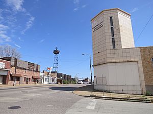
Dr Martin Luther King Drive in Wellston
|
|

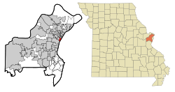
Location of Wellston, Missouri
|
|
| Country | United States |
| State | Missouri |
| County | St. Louis |
| Incorporated | 1909 |
| Dissolved | 1912 |
| Re-incorporated | 1949 |
| Area | |
| • Total | 0.93 sq mi (2.41 km2) |
| • Land | 0.93 sq mi (2.41 km2) |
| • Water | 0.00 sq mi (0.00 km2) |
| Elevation | 548 ft (167 m) |
| Population
(2020)
|
|
| • Total | 1,537 |
| • Density | 1,649.14/sq mi (636.54/km2) |
| Time zone | UTC-6 (Central (CST)) |
| • Summer (DST) | UTC-5 (CDT) |
| FIPS code | 29-78370 |
| GNIS feature ID | 2397251 |
Wellston is a city located in St. Louis County, Missouri, in the United States. It sits near the northwest edge of the city of St. Louis. In 2010, about 2,313 people lived there.
Contents
Wellston's Past: A Look at Its History
Wellston officially became a city in 1909. However, it faced some problems with its government and was no longer a city just three years later, in 1912. It became a city again in 1949. The city was named after a person called Erastus Wells.
Early Industries and Jobs
In the early 1900s, a company called Wagner Electric Company started building factories in Wellston. They made small motors for things like appliances and transformers. This company grew very large, taking up a whole city block. During World War I, it provided 4,500 jobs, which was a lot of work for people in the area.
North of the Wagner factory, another company called ABEX Corporation built a steel foundry. A foundry is a place where metal is melted and shaped. This factory started working in 1923.
Changes and Redevelopment
In 1982, ABEX moved out of Wellston. The very next year, Wagner Electric Company also closed its doors. After these big factories closed, it took a long time and a lot of money to clean up the land.
The land where Wagner Electric used to be was a "brownfield." This means it was an old industrial site that might have some pollution. It took 22 years and millions of dollars to tear down buildings and clean up 15 acres of land. This area is now called the Plymouth Industrial Park, and it's ready for new businesses.
Wellston's Location: Where It Is on the Map
Wellston covers a total area of about 0.93 square miles (2.41 square kilometers). All of this area is land, with no large bodies of water.
Getting Around: Transportation in Wellston
Wellston has a few important roads that run through it. These include Missouri Route 180, Missouri Route 340, and SR-D.
MetroLink Stations
The St. Louis MetroLink is a train system that helps people travel around the area. Wellston has its own MetroLink station called Wellston station. It has 243 parking spots where people can leave their cars and ride the train. About 1,569 passengers use this station every day.
Another MetroLink station, Rock Road station, is located right on the edge of Wellston. It has 183 parking spots and is used by about 2,408 passengers daily. This station is on St. Charles Rock Road, which is a main highway connecting St. Louis City to the northwest part of St. Louis County.
Learning in Wellston: Education
Public schools in Wellston are part of the Normandy Schools Collaborative. This group helps manage the schools in the area.
Who Lives in Wellston: Population Facts
| Historical population | |||
|---|---|---|---|
| Census | Pop. | %± | |
| 1910 | 7,312 | — | |
| 1950 | 9,396 | — | |
| 1960 | 7,979 | −15.1% | |
| 1970 | 7,050 | −11.6% | |
| 1980 | 4,495 | −36.2% | |
| 1990 | 3,612 | −19.6% | |
| 2000 | 2,460 | −31.9% | |
| 2010 | 2,313 | −6.0% | |
| 2020 | 1,537 | −33.5% | |
| U.S. Decennial Census | |||
2020 Census: A Closer Look
The United States Census Bureau collects information about people living in different areas. Here's a look at the different groups of people living in Wellston in 2020:
| Race / Ethnicity (NH = Non-Hispanic) | Pop 2000 | Pop 2010 | Pop 2020 | % 2000 | % 2010 | % 2020 |
|---|---|---|---|---|---|---|
| White alone (NH) | 155 | 54 | 35 | 6.30% | 2.33% | 2.28% |
| Black or African American alone (NH) | 2,245 | 2,200 | 1,430 | 91.26% | 95.11% | 93.04% |
| Native American or Alaska Native alone (NH) | 11 | 3 | 5 | 0.45% | 0.13% | 0.33% |
| Asian alone (NH) | 4 | 5 | 1 | 0.16% | 0.22% | 0.07% |
| Pacific Islander alone (NH) | 1 | 0 | 0 | 0.04% | 0.00% | 0.00% |
| Other race alone (NH) | 3 | 3 | 10 | 0.12% | 0.13% | 0.65% |
| Mixed race or Multiracial (NH) | 15 | 39 | 31 | 0.61% | 1.69% | 2.02% |
| Hispanic or Latino (any race) | 26 | 9 | 25 | 1.06% | 0.39% | 1.63% |
| Total | 2,460 | 2,313 | 1,537 | 100.00% | 100.00% | 100.00% |
2010 Census: More Details
In 2010, there were 2,313 people living in Wellston. There were 785 households (groups of people living together) and 540 families. The population density was about 2,487 people per square mile (960 people per square kilometer).
Most of the people in Wellston were African American (95.4%). A smaller number were White (2.4%), Native American (0.1%), or Asian (0.2%). About 1.7% of people were of two or more races. People who identified as Hispanic or Latino made up 0.4% of the population.
About 47.8% of households had children under 18 living with them. Many households (47.5%) were led by a female without a husband present. The average household had 2.95 people, and the average family had 3.62 people.
The average age of people in the city was 26.2 years. About 37% of residents were under 18 years old. About 11.4% were between 18 and 24, and 23.6% were between 25 and 44. About 8.4% of the population was 65 years or older. There were more females (55.1%) than males (44.9%) in the city.
Famous People from Wellston
- Ben McLemore (born 1993), a player in the NBA (a professional basketball league).
- Eugene Deal (born 1963), a public figure and author.
See also
 In Spanish: Wellston (Misuri) para niños
 | Tommie Smith |
 | Simone Manuel |
 | Shani Davis |
 | Simone Biles |
 | Alice Coachman |


