
Wendover Arm Canal facts for kids
Quick facts for kids Wendover Arm Canal |
|
|---|---|
.jpg)
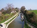
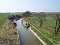
The Stop Lock to Little Tring Bridge
|
|
| Specifications | |
| Status | Part restored |
| History | |
| Original owner | Grand Junction Canal Co |
| Date of act | 1794 |
| Date completed | 1799 |
| Date closed | 1897 |
| Geography | |
| Start point | Wendover |
| End point | Bulbourne |
| Branch of | Grand Union Canal |
The Wendover Arm Canal is a special part of the Grand Union Canal in England. It's like a long, narrow river made by people. It was first planned to carry water from natural springs near Wendover in Buckinghamshire. This water would go to the main Grand Union Canal at Bulbourne in Hertfordshire.
When it opened in 1799, it was also made wide enough for boats. This was because making it navigable didn't cost much extra. However, there wasn't enough water from Wendover. So, several big water storage areas called reservoirs were built. A pumping station at Whitehouses helped move water. Later, the Tringford pumping station took over in 1817. Its old steam engines were replaced by diesel engines in 1911. Now, electric pumps do the job.
People used the canal to move coal to gasworks. They also sent straw to London for horse bedding. Horse manure was brought back from London to help farms. A flour mill and a boat-building company also used the canal. Even though people tried many times to fix leaks, the canal kept losing water. They even tried using asphalt, which was very new for this purpose. Because of the leaks, most of the canal stopped being used by boats in 1904. The water level in the top part was lowered. A pipeline was built along the canal bed to keep supplying water to Tring.
The canal became part of the Grand Union Canal in 1929. Later, British Waterways took care of it from 1963. People tried to reopen the canal in 1967 but it didn't work out. Interest grew again in 1985. In 1988, the government decided to build a special tunnel for boats where a new road would cross the canal. This led to the creation of the Wendover Arm Trust. This group started working to reopen the canal in three stages. The first stage, about 1.3 miles (2 km) from Bulbourne, was finished in 2005. They used special matting called Bentonite to stop the leaks. In 2009, the first part of stage two was filled with water. Another section was filled in 2015.
Contents
The Canal's Journey Through Time
When James Barnes designed the Grand Junction Canal, he needed to cross the Chiltern Hills. He chose a low area near Tring called the Tring Gap. The main canal was approved by Parliament in 1793. Another law in 1794 allowed branches to be built. These branches went to Buckingham, Aylesbury, and Wendover. The main canal reaches its highest point, 390 feet (120 m), at Tring summit. Boats go up through locks to reach this height. After a short flat section, the canal goes downhill at Bulbourne.
Every boat crossing the top part uses a lot of water. Barnes knew that local water wouldn't be enough. Wendover has natural springs from chalk hills that provide water all year. So, the Wendover branch was planned to bring water from these springs. This water would fill the Tringford reservoirs, which fed the Tring summit. Making the canal wide enough for boats didn't cost much more. So, it became a navigable channel when it was finished in 1799.

Water from mill streams was also added to the canal. The canal company bought mills in Wendover, Halton, and Weston Turville. They also built Weston Turville reservoir in 1798. This reservoir supplied water to mills in Aylesbury. It also helped fill the canal. A steam pump was installed in 1814 to send water to the canal.
Soon, it was clear that Wendover didn't supply enough water. So, in 1802, the first of four reservoirs was built. Wilstone reservoir came first, then Marsworth in 1806. Tringford was finished in 1814, and Startops End in 1815. Wilstone reservoir was made bigger several times. It can now hold a huge amount of water. There was a pumping station at Whitehouses. It used an old Newcomen engine to pump water. This station was later taken down when pumping moved to Tringford.
Tringford pumping station was built in 1816-1817. It had a Boulton and Watt steam engine. A second steam engine was added later. In 1911, a building for diesel engines was added. The steam engines were removed. Later, electric pumps replaced the diesel engines.
Life and Work on the Canal
The canal was used to carry coal, wood, straw, and manure. Straw went to London for horse bedding. Horse manure came back from London to be used as fertilizer on farms. Coal was delivered to a big house called Aston Clinton House. It also went to three gas works in Wendover, Halton, and near Bucklandwharf bridge. This coal was used to make gas for lighting.
In 1875, Heygates flour mill was built next to the canal. It used steam engines, and the canal supplied the water. Grain arrived by boat, and the flour was sent out by boat. After the Second World War, trucks took over from boats.
Next to the mill was a boat yard called Bushell Brothers. They built and fixed wooden boats. They also trained many skilled workers. The business closed in 1952. Very few original wooden boats from that time still exist. Only one built by Bushell's, named Roger, is known. It was built in 1936 and worked until 1968. After being used as a home and then left to rot, it was restored in 2000. It is now on the National Register of Historic Vessels. Other boats built there included a large tug named Bess and another powerful tug called Progress. Tools from Bushell Brothers are now in the Museum of English Rural Life.
Why the Canal Closed Down

The Wendover Arm Canal was used for about 100 years. A big problem was that some parts leaked water. Within 10 years of being built, parts of it were relined with clay to try and stop the leaks. There's a story that a section called The Narrows was lined with concrete and bricks. This was to stop water leaking into a nearby property, Aston Clinton House. The company tried using asphalt to line the canal in 1857. But this failed after 13 years, partly because they didn't know how to use the material well.
In 1897, a very dry year, the Grand Union company decided the canal was losing more water than it supplied. They blocked off the arm at Little Tring. By 1901, a stop lock was built there. By 1904, the canal company decided to stop using the arm for boats. The top 4 miles (6.4 km) were relined again. The water level was lowered. All the water from it was sent to Wilstone reservoir. This meant the pumps at Tringford had to work harder. So, a pipeline was laid from Drayton Beauchamp to the Tring pumping station. This pipeline ran along the bottom of the unused canal. This way, water arrived at the pumps at a higher level.
The new system still wasn't perfect. It was redesigned in 1912. After that, water was pumped straight into the main canal. Any extra water went into Tringford reservoir. The section of canal between Wendover and Drayton Beauchamp stayed filled with water. In 1917, German prisoners of war built a railway bridge over it. The railway was used to move wood from Wendover Woods. It also supplied Halton Camp, a base for the Royal Flying Corps (now RAF Halton). The railway was used until 1963. The bridge was taken down in 1965. A footbridge was later put in the same spot.
The Wendover Arm became part of the Grand Union Canal in 1929. After the government took control of canals in 1948, British Waterways took over in 1963. Now, the Canal & River Trust manages it.
Bringing the Canal Back to Life
People became interested in the canal again in 1967. The Inland Waterways Association held a meeting to talk about the future of the Grand Union Canal. In February 1967, the Grand Union Canal Society was formed. They started campaigns to reopen both the Slough Arm and the Wendover Arm. The first plan didn't work because not enough local people were interested.
By 1985, there was enough interest to form a separate Wendover Arm Group. This group included members from different canal societies. They planned a two-stage project. The first stage was from Tringford Pumping Station to Aston Clinton. The second stage covered the rest of the way to Wendover. In 1986, the group published a report called Water to Wendover to show their plans.
Their efforts got a boost in 1988. The government announced that a new road, the Aston Clinton bypass, would include a special tunnel for boats. This led to the creation of the Wendover Arm Trust. The Inland Waterways Association also chose the Wendover Arm as one of the top ten restoration projects to support.
The Wendover Arm Trust
In February 1989, the Wendover Arm Trust was formed. It's a charity that aims to restore and promote the canal. The trust gets most of its money from donations. They used to hold an annual canal festival to raise money. However, they can no longer use the site for the festival, so they are looking for new ways to get funds.
Phase 1: Getting Started

Phase 1 of the restoration covered the first 1.3 miles (2.1 km) of the canal. This was from Bulbourne Junction to Little Tring Farm. Big jobs included fixing the stop lock. They also built a winding basin at the end. This allows boats to turn around. Between these points, Little Tring Road crossed the canal. The original bridge was taken down in 1973. A new concrete bridge was built in its place. It looks traditional with bricks on the outside. The Wendover Arm Trust paid for it. This award-winning bridge was finished in 2000-2001. It cost £223,000.
The Phase 1 project was completed on March 28, 2005. The fixed section was opened. Construction had finished in November 2004. The new section was filled with water in March 2005. The total cost for this phase was £400,340.
Phase 2: More Restoration Work

Phase 2 involves a 1.75-mile (2.8 km) dry section. This runs from Little Tring to Drayton Beauchamp. It includes the boat tunnel under the Aston Clinton bypass. Earlier plans for the A41 road would have stopped the canal from being restored. But talks led to the canal being moved. This allowed enough space for boats to pass under the road. The old canal route is now a reed bed. It helps clean water from the road before it enters the new canal.
British Waterways paid to restore another 120 yards (110 m) through Drayton Beauchamp bridge. Repairs were needed there to a pipeline that runs along the bottom of the canal. This pipeline will not be needed once the work is done. But it will stay under the canal. It has to be covered with concrete to stop the restored canal from collapsing into it. As work continues, the canal channel is being reshaped. Then it's lined with a special material called Bentomat. This material has a layer of Bentonite clay between two layers of fabric. Concrete blocks are placed over the liner on the sides of the channel. Grass is planted above the water level. The dirt removed from each new section is used to cover the previous section.
The first section (Phase 1) can be used by wide boats. But Phase 2 will only fit narrow boats. The reshaped channel has sloping sides, which is good for wildlife. But it means boats can't moor there. So, three 50-yard (46 m) mooring spots have been built. About 0.25 miles (0.40 km) of this section was filled with water in 2009. It held water successfully for the first time in 120 years. Another 440 yards (400 m) was filled in 2015.
The Trust wanted to speed up progress. They considered using contractors for some work. In November 2015, they asked for a grant of £1.9 million. This was from the Heritage Lottery Fund. The request passed the first stage. But the Trust and the Canal and River Trust (CRT) withdrew their application. They found that a section near Tring bridge had been filled with harmful waste. This meant special handling and disposal would be needed. They couldn't estimate the cost in time.
Phase 3: The Final Stretch
Phase 3 goes from Drayton Beauchamp to Wendover. This part needs big engineering work on three road bridges. This section has always had water in it. But it's also important for nature. The channel will need to be cleaned. The towpath will be improved. Some banks might need to be raised and strengthened. The canal passes the site of Aston Clinton House. This was a large country house. It was later used as a school and hotel. The house was taken down. Now, the Green Park Training Centre is there.
The canal ends at a wider section called Wendover Wharf. Beyond that is a station that measures the water flow into the canal.
Exploring the Canal's Route
.jpg)
.jpg)
The water for the canal comes from springs near Wellhead Farm, south of Wendover. It also comes from the old church of St Mary. This church is made of flint and stone. It dates back to the 1300s. The water flows north through Wendover. It passes an old water mill, which is now a house. Then it enters Wendover Basin, where the canal starts. A station here checks the water flow. Records of water flow exist from 1841 to 1897, and from 1963 onwards. These are some of the earliest records in the UK.
The canal goes north. There's a path for walking on the western bank. A footbridge crosses the canal where a railway line used to be. A channel connects the canal to Weston Turville reservoir. This reservoir is a nature reserve. It's used for fishing and sailing.
The canal goes around the east and north of Halton village. It passes under Perch bridge and Halton bridge. Then it goes northeast. Near RAF Halton, there's a beautiful iron bridge. Halton House is a big country house nearby. It's been used as an officers' mess since 1919. At Harelane bridge, the path switches sides. On the other side of the canal is Green Park. This used to be the grounds of Aston Clinton House. There's a wharf there. A swing bridge used to connect the grounds to the path.
The next crossing is Bucklandwharf Bridge. This bridge carries the old A41 road. The path crosses back to the left side here. Just beyond it is a bridge for residents to reach cottages. As the canal nears the A41 bypass, the old canal bed has become a reedbed. This filters water from the road before it enters the canal. The canal has been moved south to go under the road where it's higher. After the road, the canal joins its original path. It continues to Drayton Beauchamp bridge.
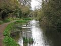
The section beyond Drayton Beauchamp bridge had a pipe to keep water flowing to Tringford pumping station. Some of this section is now filled with water again. This is where the Wendover Arm Trust is working. The canal crosses the border between Buckinghamshire and Hertfordshire. Then there are two wooden footbridges. These were put up in 2007 to make it easier to reach the canal bed during restoration. Between them, the remains of Whitehouses wharf and pumping station have been dug up. Part of the canal was filled with rubbish in the early 1900s. Bottle collectors dug it up before restoration began. There's a short section without a path near Little Tring bridge. But walkers can use a small road to rejoin the canal, which is navigable here.
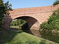
A public path follows the right bank for most of the way to Gamnel Bridge. But it leaves the canal to join the B488 road at Tring. Another path runs along the left bank. It passes the Tring pumping station, Heygates flour mill, and the site of Bushell's Boat Yard. This is the only part of the canal built on a raised bank. Gamnel Bridge is from 1797. It's a narrow, hump-backed bridge made of brown bricks.
To the left of the final section is Tring Sewage Treatment Works. It was built in the late 1800s. Its outflow usually adds water to the canal. However, between July 2012 and April 2013, the filters failed several times. The canal became polluted with sewage. The Environment Agency took legal action against the operators, Thames Water. They were fined £1 million, the largest fine ever for such a case. Thames Water later replaced the filters.
The Wendover Arm joins the main Grand Union Canal at a footbridge. Next to it is a toll house. To the north, the main canal goes downhill through the Marsworth locks. To the south, it stays level to Bulbourne and beyond.
Images for kids
-
The Stop Lock to Little Tring Bridge
-
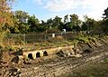
What's left of Whitehouses pumping station after digging in 2015
-
A part of the canal near Wendover that is no longer used
-
Rebuilding of Little Tring Road bridge was finished in 2001.
-
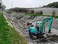
Lining the dry canal bed near Drayton Beauchamp in April 2009
-
Phase 1: Little Tring Bridge to Winding Basin
-
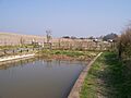
The end of the navigable part of Phase 1 near Little Tring Farm
