
Wendover facts for kids
Quick facts for kids Wendover |
|
|---|---|
 The Clock Tower, Wendover |
|

Wendover
|
|
| Area | 9.1125 sq mi (23.601 km2) |
| Population | 7,399 (2011 Census) |
| • Density | 812/sq mi (314/km2) |
| OS grid reference | SP864085 |
| Civil parish |
|
| Unitary authority |
|
| Ceremonial county | |
| Region | |
| Country | England |
| Sovereign state | United Kingdom |
| Post town | AYLESBURY |
| Postcode district | HP22 |
| Dialling code | 01296 |
| Police | Thames Valley |
| Fire | Buckinghamshire |
| Ambulance | South Central |
| EU Parliament | South East England |
| UK Parliament |
|
Wendover is a town and civil parish located at the bottom of the Chiltern Hills in Buckinghamshire, England. It sits where a main road from London to Aylesbury crosses an old road that runs along the Chiltern Hills. The town is about 35 miles (56 km) north-west of London and 5 miles (8 km) south-east of Aylesbury.
The parish covers an area of 5,832 acres (2,360 hectares). In 2011, about 7,399 people lived here. Outside the main town, the parish mostly has farms and includes several small villages called hamlets in the surrounding hills. Wendover has a market every week. It has been allowed to hold a market since 1464.
Contents
- What's in a Name?
- A Look at Wendover's Past
- Wendover's Location and Surroundings
- How Wendover is Governed
- Local Businesses and Fun Spots
- Famous Places and Views
- Getting Around Wendover
- Media and News
- Schools in Wendover
- Sports and Activities
- Famous People from Wendover
- Twin Town
- Images for kids
- See also
What's in a Name?
The name "Wendover" likely comes from an old Celtic language. The first part, "wyn" or "gwyn," might mean "white," similar to the modern Welsh word. The second part, "dwr," could come from "dwfr," meaning "water." This old word for water is also where the city of Dover gets its name.
A Look at Wendover's Past
The first time Wendover was mentioned in writing was between 965 and 971. Back then, it was called Wændofron. Before the Norman Conquest in 1066, King Edward the Confessor owned the land. The town seemed to be located about 600 meters (about 2,000 feet) south of where it is today, near the church of St Mary. By 1086, the area was known as Wendovre. William the Conqueror was the main owner of the land.
Wendover stayed under royal ownership until 1154. After that, it changed hands between the king and private owners many times. In 1214, Wendover was given permission to hold a market. By 1228, it had become a borough, which is a town with special rights. Around this time, the town probably moved north to its current spot. This allowed the market to serve people traveling on the road along the Chilterns, as well as those crossing the hills. The older parts of the town show signs of careful planning from the medieval times.
.jpg)
During the English Civil War, both sides, the Parliamentarians (Roundheads) and the Royalists (Cavaliers), visited Wendover. Both groups were reported to have taken things from the town. Many buildings in the town center, especially on High Street, Pound Street, and Aylesbury Road, were built in the 1600s. We don't know if this was because they needed rebuilding after the war or if it showed how well the town was doing then.
In 1721, a new road system was set up, making Wendover a stop for coaches traveling to and from London. Many new inns and hotels were likely built along the High Street at this time. The Wendover Arm of the Grand Union Canal was built between 1793 and 1797. It helped local businesses and supplied water to the main canal. In September 1892, the railway arrived when Wendover railway station opened.
In 1913, Alfred de Rothschild invited the Royal Flying Corps to train on his land nearby in Halton. This land continued to be used by the British Army during the First World War. In 1916, the Royal Flying Corps moved its air mechanics school to Halton. This school later became RAF Halton. Even though the base isn't in Wendover, it affected the town by bringing more people and leading to trees being cut down for building materials.
In the late 1900s, many new homes were built, especially north of the town. In 1998, the Wendover bypass was built. This moved the A413 road away from the town center, running next to the railway line. Property prices went up after the bypass was finished because it reduced traffic on the town's narrow streets. In 2010, plans were released for the High Speed 2 (HS2) rail line. It showed the line going in a tunnel west of the bypass and town center. Despite protests from local groups, the HS2 plan was approved in 2016, and construction began in 2017.
Wendover's Location and Surroundings

Wendover is about 130 meters (426 feet) above sea level. It's in a great spot at the northern end of a natural path through the Chiltern Hills. These hills surround the town to the west, south, and east. To the north, the land gently slopes down to the flat, farming area of the Aylesbury Vale. To the west, Coombe Hill (260 meters or 853 feet) overlooks the town. To the east is Wendover Woods (267 meters or 876 feet).
.jpg)
The gap in the Chilterns where Wendover is located has always been an important route for travel. The A413 road from London to Aylesbury uses it, as does the London to Aylesbury railway line. The new high-speed rail line from London to the North is also being built here. At Wendover, this route crosses the ancient Icknield Way. This old path has connected Wiltshire to Norfolk since prehistoric times.
Besides the town itself, the parish includes several small villages called hamlets:
- Dean
- Kings Ash or Kingsash
- Little London
- Lower Bacombe
- Smalldean
- The Hale
- Upper Bacombe
- Wendover Dean
How Wendover is Governed
Wendover used to have its own representative in Parliament. This happened off and on from 1300 and then continuously from 1660. However, this special seat was removed in 1832. Now, the town and parish are part of the Aylesbury parliamentary area. This area had elected a Conservative Member of Parliament since 1924. But in 2024, Laura Kyrke-Smith from the Labour Party won the seat.
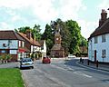
Wendover has two levels of local government. There is the Wendover Parish Council and the Buckinghamshire Council. The parish council has its office at the Clock Tower on High Street.
Local Businesses and Fun Spots

In the town center, you can find a post office, several hair salons, a community library (run by volunteers), many delis and cafés, a pharmacy, and a charity shop. There is also an open market every Thursday.
Wendover has several pubs, including The Red Lion, The George & Dragon, The White Swan, The King and Queen, The Pack Horse, and The Shoulder of Mutton. The Red Lion pub was famous for having 'Britain's Oldest Barmaid,' Dolly Saville. She was 100 years old and worked there for 74 years!
Famous Places and Views

Wendover has 113 listed buildings, which means they are important for their history or architecture. Five of these are especially important. These include the parish church, its lychgate, Bank Farmhouse, the Hale, and the Red House.
In the center of town, at the corner of High Street and Tring Road, there is a unique red brick clock tower with a spire. It was built in 1842. The ground floor of the tower is used as the office for the parish council. Aylesbury Street is lined with trees and features Chiltern House, a timber-framed building from the 1500s, and the Red House, from the 1700s.
North of the town center is the end of the Wendover Arm of the Grand Union Canal. This canal connects to the main Grand Union line near Tring. The arm was not used for over 100 years, but the Wendover Arm Trust is now working to restore it. This quiet, rural canal is home to lots of local wildlife, including a group of mandarin ducks. You can walk along the canal for about 5 miles (8 km) from Wendover to Tring.
.jpg)
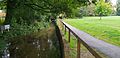
South of the town center are open green spaces like Witchell Meadow, Hampden Meadow, and Rope Walk Meadow. Rope Walk Meadow has a new Wendover Community Orchard, planted to remember those from the First World War. These areas are bordered by the Heron Stream to the east and Hampden Pond to the south. Both of these feed the canal. On the south side of the pond is Wendover's parish church, dedicated to St Mary. This church marks the spot of the town's original settlement.

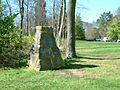
The town is located in a gap in the Chiltern Hills, which is a special Area of Outstanding Natural Beauty. The ancient Ridgeway National Trail, an 85-mile (137 km) walking path, goes right through Wendover High Street. Besides the Ridgeway Trail, there are 33 miles (53 km) of public paths and bridleways that cross the parish. These lead to the open chalk hills of Coombe Hill, Buckinghamshire. Here you can find Britain's longest-lasting geocache and a monument to the Buckinghamshire men who died in the Boer War. Wendover Woods on Haddington Hill and Boddington Hill are managed by Forest Enterprise England. They have routes for mountain bikers, walking trails for different abilities, barbecue spots, and play areas for children. On Boddington Hill, you can see the remains of an Iron Age hill fort called Boddington Camp.
Wendover and nearby villages like Aston Clinton, Ellesborough, and Weston Turville are considered very nice places to live. In 2018, The Sunday Times even named Wendover one of the best places to live in Britain.
Getting Around Wendover
The town has a train station, Wendover station. It is served by Chiltern Railways trains that go to and from London Marylebone on the London to Aylesbury Line.
Two bus routes pass through Wendover. The number 8 bus travels between Aylesbury and RAF Halton. The number 55 bus travels between Aylesbury and Chesham.
Media and News
For local news and TV, people in Wendover can watch BBC South and ITV Meridian. TV signals come from the Oxford TV transmitter.
Local radio stations include BBC Three Counties Radio, Heart East, Greatest Hits Radio Bucks, Beds and Herts, and Red Kite Radio. Red Kite Radio is a community station that broadcasts from Aylesbury.
The town also has local newspapers like the Bucks Herald, Bucks Free Press, and Wendover News.
Schools in Wendover
There are four schools in the town:
- The John Hampden School: This is an infant school for children aged 4–7, with about 275 pupils. It is named after the politician John Hampden.
- Wendover Church of England Junior School: This is a junior school for children aged 7–11, with about 360 pupils.
- The John Colet School: This is a secondary school for students aged 11–18, with about 1100 pupils. It is named after the Renaissance thinker John Colet.
- The Wendover campus of the Chiltern Way Academy: This is a special school for pupils aged 11–18.
Sports and Activities
Wendover Football Club plays on the school fields of the John Colet School. They have a clubhouse that opens on Saturday afternoons for games.
Wendover also hosts the 'Coombe Hill Run,' usually in early June. This race starts and ends in town and includes two very steep climbs up Coombe Hill to the monument, along with a very steep downhill section.
Wendover Cricket Club used to play at Ellesborough Road Ground. However, this site was in the way of the High Speed 2 railway line. The club will move to a new location, paid for by HS2 Ltd, in the future.
Famous People from Wendover
Many notable people have connections to Wendover:
- Thomas Barlow (1845–1945), a doctor
- Edmund Burke (1729–1797), a member of parliament
- David Jason (born 1940), an actor
- John Junkin (1930–2006), an actor and writer
- Geoffrey Palmer (1927–2020), an actor
- Cecilia Payne-Gaposchkin (1900–1979), an astronomer
- Roger of Wendover (?–1236), a historian
- Katie Malliff (born 2003), a professional squash player
Twin Town
Wendover is twinned with Liffré in Brittany, France.
Images for kids
-
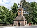
The Clock Tower, Wendover
-
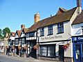
The Red Lion, one of Wendover's old coaching inns on the High Street
-

The market place in Wendover, with the Chiltern escarpment and Wendover Woods beyond
-
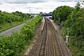
The bypass and railway station to the west of Wendover and looking north; the new High Speed 2 rail link will be in a tunnel further to the left
-
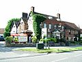
The Shoulder of Mutton public house
-
View of Wendover Clock Tower from Aylesbury Rd
-
Heron Stream and Witchell Meadow
-
Wendover Woods
See also
 In Spanish: Wendover para niños
