West, Mississippi facts for kids
Quick facts for kids
West, Mississippi
|
|
|---|---|

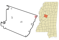
Location of West, Mississippi
|
|
| Country | United States |
| State | Mississippi |
| County | Holmes |
| Area | |
| • Total | 0.56 sq mi (1.44 km2) |
| • Land | 0.56 sq mi (1.44 km2) |
| • Water | 0.00 sq mi (0.00 km2) |
| Elevation | 292 ft (89 m) |
| Population
(2020)
|
|
| • Total | 153 |
| • Density | 274.19/sq mi (105.96/km2) |
| Time zone | UTC-6 (Central (CST)) |
| • Summer (DST) | UTC-5 (CDT) |
| ZIP code |
39192
|
| Area code(s) | 662 |
| FIPS code | 28-78680 |
| GNIS feature ID | 679466 |
West is a small town located in the northeastern part of Holmes County, Mississippi, in the United States. According to the 2020 census, about 153 people live there. As of December 2020, the Mayor of West is Michael Fancher.
Contents
History of West, Mississippi
In 1989, West gained national attention because of a football game. A school called East Holmes Academy, which was all-white and is now closed, first refused to play against Heritage Academy. This was because Heritage Academy had a Black player on their team.
However, things changed quickly. Seven players from East Holmes Academy quit their team. Also, two members of the school board resigned. The Mississippi Private School Association even threatened to remove the school from their league. Because of these actions, East Holmes Academy decided to play the game after all.
Geography and Location
West is located on the eastern side of Holmes County, Mississippi. The Big Black River forms the eastern border of the town. This river also marks the line for Attala County. West is the town farthest east in Holmes County.
U.S. Route 51 goes right through the middle of West. If you go north on this road, it's about 10 miles to Vaiden. Going south for about 9 miles will take you to Durant.
Interstate 55 is about 3 miles west of West. You can get onto I-55 from Exit 164, which is Emory Road. This interstate goes south about 70 miles to Jackson, the state capital. If you go north on I-55, it's about 140 miles to Memphis, Tennessee. Also, Mississippi Highway 19 goes southeast from West for about 17 miles to Kosciusko.
The United States Census Bureau states that the town of West covers a total area of about 1.4 square kilometers. All of this area is land.
Population and Demographics
| Historical population | |||
|---|---|---|---|
| Census | Pop. | %± | |
| 1880 | 200 | — | |
| 1900 | 196 | — | |
| 1910 | 276 | 40.8% | |
| 1920 | 236 | −14.5% | |
| 1930 | 370 | 56.8% | |
| 1940 | 402 | 8.6% | |
| 1950 | 354 | −11.9% | |
| 1960 | 282 | −20.3% | |
| 1970 | 305 | 8.2% | |
| 1980 | 253 | −17.0% | |
| 1990 | 184 | −27.3% | |
| 2000 | 220 | 19.6% | |
| 2010 | 185 | −15.9% | |
| 2020 | 153 | −17.3% | |
| U.S. Decennial Census 2010 2020 |
|||
2020 Census Data
| Race / Ethnicity | Pop 2010 | Pop 2020 | % 2010 | % 2020 |
|---|---|---|---|---|
| White alone (NH) | 88 | 80 | 47.47% | 52.29% |
| Black or African American alone (NH) | 97 | 68 | 52.43% | 44.44% |
| Native American or Alaska Native alone (NH) | 0 | 0 | 0.00% | 0.00% |
| Asian alone (NH) | 0 | 2 | 0.00% | 1.31% |
| Pacific Islander alone (NH) | 0 | 0 | 0.00% | 0.00% |
| Some Other Race alone (NH) | 0 | 0 | 0.00% | 0.00% |
| Mixed Race/Multi-Racial (NH) | 0 | 2 | 0.00% | 1.31% |
| Hispanic or Latino (any race) | 0 | 1 | 0.00% | 0.65% |
| Total | 185 | 153 | 100.00% | 100.00% |
Note: The U.S. Census counts Hispanic/Latino people as an ethnic group. This means they are listed separately from racial categories. People who are Hispanic/Latino can be of any race.
Education in West
The schools in the town of West are part of the Holmes County School District.
See also
 In Spanish: West (Misisipi) para niños
 | Valerie Thomas |
 | Frederick McKinley Jones |
 | George Edward Alcorn Jr. |
 | Thomas Mensah |


