West Bountiful, Utah facts for kids
Quick facts for kids
West Bountiful, Utah
|
|
|---|---|

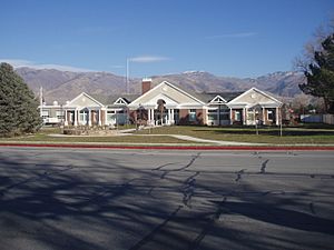
West Bountiful City Hall
|
|

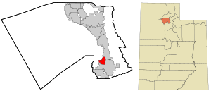
Location in Davis County and the state of Utah
|
|
| Country | United States |
| State | Utah |
| County | Davis |
| Settled | 1848 |
| Incorporated | January 28, 1949 |
| Became a city | November 12, 1962 |
| Founded by | James Fackrell, Sr. |
| Named for | Bountiful (Book of Mormon) |
| Area | |
| • Total | 3.32 sq mi (8.59 km2) |
| • Land | 3.31 sq mi (8.56 km2) |
| • Water | 0.01 sq mi (0.03 km2) |
| Elevation | 4,232 ft (1,290 m) |
| Population
(2010)
|
|
| • Total | 5,265 |
| • Estimate
(2019)
|
5,800 |
| • Density | 1,754.92/sq mi (677.57/km2) |
| Time zone | UTC-7 (Mountain (MST)) |
| • Summer (DST) | UTC-6 (MDT) |
| ZIP code |
84087
|
| Area code(s) | 385, 801 |
| FIPS code | 49-82840 |
| GNIS feature ID | 2412217 |
West Bountiful is a city located in Davis County, Utah, in the United States. It's part of a larger area called the Ogden–Clearfield Metropolitan Statistical Area. In 2010, about 5,265 people lived here. By 2018, the population was estimated to be around 5,731.
Contents
History of West Bountiful
West Bountiful was first settled in 1848 by a man named James Fackrell, Sr. He was a Mormon pioneer. James Fackrell was born in England in 1787.
He moved to the United States and traveled across the plains in 1848 with his family. He and his wife, Amy Crumb, then settled in the area that became West Bountiful.
West Bountiful officially became a town on January 28, 1949. Later, on November 12, 1962, it became a third-class city.
Geography of West Bountiful
West Bountiful is in the southeastern part of Davis County. It shares borders with several other cities. To the north is Centerville. To the east is Bountiful.
To the south, you'll find Woods Cross. To the west is the Legacy Nature Preserve.
Interstate 15, a major highway, runs through the eastern part of the city. You can get on or off the highway at Exits 316 and 317. Downtown Salt Lake City is about 11 miles (18 km) to the south.
The United States Census Bureau says that West Bountiful covers a total area of about 3.3 square miles (8.4 square kilometers). A very small part of this area, about 0.01 square miles (0.03 square kilometers), is water.
Education in West Bountiful
West Bountiful is part of the Davis School District. The city has one school within its borders, which is West Bountiful Elementary.
After elementary school, students from West Bountiful attend Bountiful Junior High. They then go to Viewmont High School in Bountiful.
Population and People
| Historical population | |||
|---|---|---|---|
| Census | Pop. | %± | |
| 1900 | 433 | — | |
| 1910 | 534 | 23.3% | |
| 1920 | 573 | 7.3% | |
| 1930 | 608 | 6.1% | |
| 1940 | 951 | 56.4% | |
| 1950 | 682 | −28.3% | |
| 1960 | 945 | 38.6% | |
| 1970 | 1,246 | 31.9% | |
| 1980 | 3,556 | 185.4% | |
| 1990 | 4,477 | 25.9% | |
| 2000 | 4,484 | 0.2% | |
| 2010 | 5,265 | 17.4% | |
| 2019 (est.) | 5,800 | 10.2% | |
| U.S. Decennial Census | |||
In the year 2000, there were 4,484 people living in West Bountiful. These people lived in 1,250 households. Most of the households, 1,102, were families.
The city had about 1,511 people per square mile (583 people per square kilometer). Most of the people living in West Bountiful were White (96.23%). There were also smaller groups of other races. About 2.03% of the population was Hispanic or Latino.
Many households (55.0%) had children under 18 living with them. About 76.9% of households were married couples living together. The average household had about 3.59 people.
The population was spread out by age. About 35.6% of the people were under 18 years old. About 12.5% were between 18 and 24. Around 27.3% were between 25 and 44. About 20.4% were between 45 and 64, and 4.2% were 65 or older. The average age in the city was 27 years old.
See also
 In Spanish: West Bountiful para niños


