
West Coyote Hills facts for kids
Quick facts for kids West Coyote Hills |
|
|---|---|

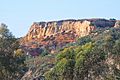
cliffs in Coyote Hills
|
|
| Highest point | |
| Elevation | 184 m (604 ft) |
| Geography | |

Location in California
|
|
| Country | United States |
| State | California |
| District | Orange County |
| Range coordinates | 33°54′19.050″N 117°57′44.224″W / 33.90529167°N 117.96228444°W |
| Topo map | USGS La Habra |
The West Coyote Hills are a group of small hills in northern Orange County, California. They are one of the last big open spaces in this busy part of Orange County. These hills stretch across parts of La Habra, Buena Park, and La Mirada. Most of the hills are in western Fullerton, located between Ralph B. Clark Regional Park and Euclid Street. The area to the east and south is called Sunny Hills. There's also an East Coyote Hills area, but it has mostly been built up with homes.
The remaining open land in West Coyote Hills is currently part of a big discussion. Some people want to build more homes there. Others, called conservationists, want to protect the land and keep it as open space. A company called Chevron is suggesting to build on some parts of the land. They plan to leave the rest of the area as natural open space.
Contents
What's in a Name? The Coyote Hills Story
The West Coyote Hills got their name from a nearby old ranch called Rancho Los Coyotes. By the 1870s, people were already calling them the Coyote Hills. This name makes sense because real coyotes still live in the area today!
Plants and Trees in West Coyote Hills
The natural areas of the Coyote Hills are covered with a type of plant community called coastal sage scrub. You can find native plants like buckwheat and prickly pear cactus here. Some plants that are not native to the area also grow, such as pepper trees, tobacco trees, and mustard plants.
There are no natural creeks in the hills, except for small streams that appear after heavy rainstorms. This means there are no native plants that need a lot of water, like oak trees. Along the edges of the hills, near houses and city trails, you can see tall eucalyptus trees and some pine trees.
How the Land Looks: Topography of the Hills
The West Coyote Hills have been changed quite a bit over time. Large earth-moving projects have made some of the steep hills and canyons flatter. This allowed for the building of Gilbert Street, new homes, and a golf course on the west side of Gilbert Street.
East of Gilbert Street, the undeveloped area is mostly a gentle slope that faces north and gets a lot of sun. The larger area west of Gilbert Street has more rugged land with many south-facing slopes. It also has a long, dry canyon with a flat bottom that runs north to south. The bottom of this canyon has been paved. It serves as a fire road that firefighters can use from a nearby fire station. The steep sides of the canyon were flattened into terraces and have asphalt roads. These roads were built for oil drilling. You can see impressive cliffs in this area, which are a landmark for drivers on Rosecrans Avenue.

Ancient Life: Fossils in the Hills
Scientists from the U.S. Geological Survey have found many amazing fossils in the Coyote Hills. They found fossils from 184 different types of creatures at 158 locations! These fossils were in a rock layer called the "San Pedro" Formation.
The fossils include different kinds of worms (annelids), snails and clams (mollusks), insects and crabs (arthropods), and sea urchins (echinoids). These fossils tell us that the rocks are from a very long time ago, between the late Pliocene and early Pleistocene periods.
One special find was a type of clam called Solamen columbianum. This was the first time this clam had ever been found as a fossil! Scientists also found the oldest known fossils of certain snails, like Tegula pulligo and possibly Haliotis cracherodii. The oldest fossil of a crab called Randallia ornata was also discovered here.

The Risner Fire: A Story of Wildfire
On September 8 and 9, 2015, a brush fire called the Risner fire started in the West Coyote Hills. It began at a temporary camp in the area. The fire burned about 80 acres of land. Because of the fire, about 40 homes nearby had to be evacuated to keep people safe.
Images for kids
-
cliffs in Coyote Hills
