
West Easton, Pennsylvania facts for kids
Quick facts for kids
West Easton
|
|
|---|---|
|
Borough
|
|
| Borough of West Easton | |

War Monument Park in West Easton in May 2019
|
|

Location of West Easton in Northampton County, Pennsylvania (left) and of Northampton County in Pennsylvania (right)
|
|

West Easton
Location in Pennsylvania

West Easton
Location in the United States
|
|
| Country | |
| State | |
| County | Northampton |
| Incorporated | June 6, 1898 |
| Government | |
| • Type | Strong Council |
| Area | |
| • Borough | 0.34 sq mi (0.87 km2) |
| • Land | 0.30 sq mi (0.79 km2) |
| • Water | 0.03 sq mi (0.08 km2) |
| Elevation | 230 ft (70 m) |
| Population
(2010)
|
|
| • Borough | 1,257 |
| • Estimate
(2019)
|
1,250 |
| • Density | 4,098.36/sq mi (1,580.75/km2) |
| • Metro | 865,310 (US: 68th) |
| Time zone | UTC-5 (EST) |
| • Summer (DST) | UTC-4 (EDT) |
| ZIP Code |
18042
|
| Area code(s) | 610 and 484 |
| Primary airport | Lehigh Valley International Airport |
| Major hospital | Lehigh Valley Hospital–Cedar Crest |
| School district | Wilson Area |
| Website | www.westeastonborough.com |
West Easton is a small town, called a borough, located in Northampton County, Pennsylvania. In 2010, about 1,257 people lived there. West Easton is part of the larger Easton area and the Lehigh Valley region. This whole area is home to over 860,000 people, making it one of the biggest metropolitan areas in the U.S.
Contents
History
How West Easton Started
West Easton's story began a long time ago with the family of William Penn, who founded Pennsylvania. In 1737, Penn's family sold a large piece of land (500 acres) to James Hamilton. This land was later sold to Garrett Moor, and then in 1772, John Philip Odenwelder, Sr. bought 200 acres from Mr. Moor.
Growing Villages
In 1834, William Penn's son, John Penn, planned out a small community called Odenweldertown. Next to this area, another village named Mutchlertown grew up in 1872. By 1877, Mutchlertown had 35 wooden houses.
Becoming a Borough
West Easton officially became a borough on June 6, 1898. This happened when the Court of Quarter Sessions in Northampton County, Pennsylvania approved it. Many property owners were against the idea, but a small majority wanted it. After a big discussion, a judge decided to allow Odenweldertown and Mutchlertown to join together and become The Borough of West Easton. The first leaders of the borough were chosen on July 12, 1898.
Life in the 20th Century
In the 1920s and 1930s, West Easton was a busy place with many factories making things like textiles (cloth). There were also lots of small businesses. The number of people living there grew a lot during this time. West Easton had its own school, sports teams for kids, and even a trolley system. It also had a police department and a volunteer fire company. Many citizens helped out in community groups.
After World War II, things started to change. Factories began to close because of new technologies and goods coming from other countries. This meant fewer jobs in West Easton, and the population started to shrink. The local school closed in 1974, and youth sports programs ended. The West Easton Police Department closed in 1965. For many years, police protection came from nearby towns or the Pennsylvania State Police.
West Easton Today
In 2015, new leaders were elected to the borough council. They wanted to make local government more open and get more grants (money for projects). They also encouraged people to volunteer and brought back community activities. They even looked into starting their own police department again.
In 2017, Mayor Gerald Gross, who had served the borough for 52 years, decided not to run for re-election. Dan DePaul, who was the Council President, became the new mayor. The new council started fixing roads and sidewalks. They used a grant to complete a $124,000 project to fix storm drains, which helped stop flooding. In 2018, West Easton began building its first Public Works Building. They also started working on creating a new police force. In May 2019, they improved War Monument Park by adding The Gold Star Fountain.
After 54 years, West Easton got its own chief of police in November 2019. Some people worried that a new police department would be too expensive. However, the actual cost was much lower than expected, with most of it paid for by grants and donations. The part-time police department started in mid-2021 due to the COVID-19 pandemic. The state police still help out when the local police are not on duty.
In 2022, the local volunteer fire company changed its name to West Easton Volunteer Fire Company #1. It now gets a lot of financial help from the borough.
How West Easton is Governed
West Easton has a "strong council–weak mayor" system of government. This means the borough council makes most of the decisions, like creating new rules (ordinances) and policies. The mayor only votes if there's a tie among the council members. The mayor can also stop a new rule (veto it), but the council can vote to overrule the mayor's decision. The mayor is also in charge of the police department.
The borough council has seven members. Citizens of West Easton vote for these members. The council members then choose a council president, vice president, and president pro tempore from among themselves. The council also hires people like the borough manager and treasurer, who help run the borough every day.
Geography
West Easton is located at 40°40′42″N 75°14′10″W / 40.67833°N 75.23611°W. The U.S. Census Bureau says the borough covers about 0.3 square miles (0.8 square kilometers). Most of this area is land, but a small part, about 0.04 square miles (0.1 square kilometers), is water.
Transportation

In 2007, West Easton had about 5.90 miles (9.50 kilometers) of public roads. Some of these roads (about 1.52 miles or 2.45 kilometers) are kept up by the Pennsylvania Department of Transportation (PennDOT). The rest (about 4.38 miles or 7.05 kilometers) are maintained by the borough itself.
Some of the main roads in West Easton include Lehigh Drive, Glendon Hill Road, Iron Street, Avona Avenue, East Street, and Main Street.
Population Facts
| Historical population | |||
|---|---|---|---|
| Census | Pop. | %± | |
| 1900 | 1,000 | — | |
| 1910 | 1,033 | 3.3% | |
| 1920 | 1,408 | 36.3% | |
| 1930 | 1,564 | 11.1% | |
| 1940 | 1,159 | −25.9% | |
| 1950 | 1,368 | 18.0% | |
| 1960 | 1,228 | −10.2% | |
| 1970 | 1,123 | −8.6% | |
| 1980 | 1,033 | −8.0% | |
| 1990 | 1,163 | 12.6% | |
| 2000 | 1,152 | −0.9% | |
| 2010 | 1,257 | 9.1% | |
| 2020 | 1,237 | −1.6% | |
| Sources: | |||
In 2010, there were 1,257 people living in West Easton. There were 488 households (groups of people living together) and 175 families. On average, about 4,008 people lived in each square mile.
Most people in West Easton were White (85.0%). There were also African American (3.8%), Native American (0.3%), and Asian (0.7%) residents. About 8.4% of the population was Hispanic or Latino.
About 33.4% of households had children under 18. Many households (50.7%) were married couples living together. The average household had 2.55 people, and the average family had 3.04 people.
The population was spread out by age:
- 25.0% were under 18 years old.
- 7.7% were 18 to 24 years old.
- 32.1% were 25 to 44 years old.
- 21.4% were 45 to 64 years old.
- 13.7% were 65 years or older.
The average age in West Easton was 38 years.
The average yearly income for a household was $39,615, and for a family it was $48,393. About 9.9% of all people, including 11.2% of those under 18, lived below the poverty line.
Public Education
Students in West Easton attend schools in the Wilson Area School District. Older students, from ninth to twelfth grade, go to Wilson Area High School.
Churches
- Holy Ghost Ukrainian Catholic Church
Gallery
-
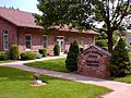
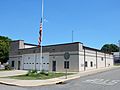
Borough Hall
-
Borough Hall
-
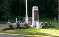
Monument Park
-
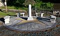
War Memorial Fountain
-
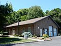
West Easton Fire Co.
-
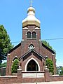
Ukrainian Catholic Church
-
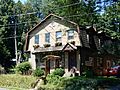
House on Spring Street
-
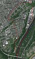
Satellite Image of West Easton


See also
 In Spanish: West Easton para niños
