West Island (California) facts for kids

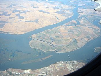
West Island is the long, thin island in the bottom left of this photo. The larger island is Sherman Island, and the bridge goes down to Antioch.
|
|
| Geography | |
|---|---|
| Location | Northern California |
| Coordinates | 38°01′24″N 121°46′43″W / 38.02333°N 121.77861°W |
| Adjacent bodies of water | San Joaquin River |
| Administration | |
| State | |
| County | Sacramento |
West Island is a small piece of land completely surrounded by water. It is located in the San Joaquin River in Northern California. This island is part of Sacramento County. You can find it at these coordinates: 38°01′24″N 121°46′43″W / 38.02333°N 121.77861°W.
Contents
What is West Island?
West Island is a natural island. It sits within the San Joaquin River, which is a major river in California. The island is quite small. It is mostly covered in plants and trees.
Where is West Island Located?
West Island is found in the northern part of California. It is specifically located within the area known as the Sacramento–San Joaquin River Delta. This delta is where the Sacramento and San Joaquin rivers meet. It is a very important natural area.
West Island's County
Even though it's an island, West Island belongs to a specific county. It is part of Sacramento County. This county is known for its capital city, Sacramento.
A Look Back in Time: West Island's History
West Island has been on maps for a long time. Early explorers and mapmakers recorded its presence.
How Was West Island Mapped?
On an old map from 1850, West Island was shown. This map was made by Cadwalader Ringgold. He was a surveyor who mapped the San Francisco Bay Area. On his map, West Island was called "Webers Island."
Another map from 1854 also showed the island. This map was created by Henry Lange. These old maps help us understand how the area has changed over time. They also show that West Island has been a known landmark for many years.
 | Victor J. Glover |
 | Yvonne Cagle |
 | Jeanette Epps |
 | Bernard A. Harris Jr. |


