West Logan, West Virginia facts for kids
West Logan is a small town located along the Guyandotte River in Logan County, West Virginia, United States. In 2020, about 400 people lived there. The town gets its name because it is located west of the county seat, which is the city of Logan.
Quick facts for kids
West Logan, West Virginia
|
|
|---|---|

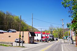
West Virginia Route 10 (Old Logan Road) in West Logan, April 2018
|
|

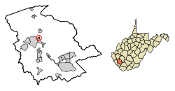
Location of West Logan in Logan County, West Virginia
|
|
| Country | United States |
| State | West Virginia |
| County | Logan |
| Area | |
| • Total | 0.34 sq mi (0.87 km2) |
| • Land | 0.34 sq mi (0.87 km2) |
| • Water | 0.00 sq mi (0.00 km2) |
| Elevation | 682 ft (208 m) |
| Population
(2020)
|
|
| • Total | 400 |
| • Estimate
(2021)
|
391 |
| • Density | 1,076.92/sq mi (416.35/km2) |
| Time zone | UTC-5 (Eastern (EST)) |
| • Summer (DST) | UTC-4 (EDT) |
| ZIP code |
25601
|
| Area code(s) | 304 |
| FIPS code | 54-85900 |
| GNIS feature ID | 1555948 |
Contents
Geography of West Logan

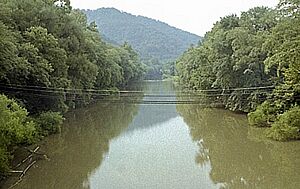
West Logan is located at 37°52′10″N 81°59′14″W / 37.869557°N 81.987282°W. The town is mainly built on the flat land along the west side of the Guyandotte River. Its borders reach west to the top of a hill called Rattlesnake Knob.
The community of Peach Creek is across the river to the northeast. The community of Aracoma is to the southwest.
Roads and Transportation
West Virginia Route 10 (also known as 2nd Avenue) goes through West Logan. This road connects the town to Logan in the southeast. It also connects to Mitchell Heights and Chapmanville to the north.
A bridge on Old Guyan River Road crosses the Guyandotte River. This bridge helps people get to the Peach Creek area.
Town Size
According to the United States Census Bureau, West Logan covers a total area of about 0.34 square miles (0.87 square kilometers). All of this area is land.
Population of West Logan
| Historical population | |||
|---|---|---|---|
| Census | Pop. | %± | |
| 1960 | 855 | — | |
| 1970 | 685 | −19.9% | |
| 1980 | 630 | −8.0% | |
| 1990 | 524 | −16.8% | |
| 2000 | 418 | −20.2% | |
| 2010 | 424 | 1.4% | |
| 2020 | 400 | −5.7% | |
| 2021 (est.) | 391 | −7.8% | |
| U.S. Decennial Census | |||
Population in 2010
In 2010, the town had 424 people living in it. There were 188 households, which are groups of people living together. About 109 of these were families.
The population density was about 1,247 people per square mile (481 people per square kilometer). There were 221 housing units, like houses or apartments. The average density was about 650 housing units per square mile (251 per square kilometer).
Most of the people in West Logan were White (97.4%). A small number were African American (0.2%), Asian (0.9%), or from two or more races (1.4%).
Households and Families
Out of the 188 households:
- 27.7% had children under 18 living with them.
- 37.8% were married couples living together.
- 14.4% had a female head of the household with no husband present.
- 5.9% had a male head of the household with no wife present.
- 42.0% were not families.
About 38.3% of all households had only one person living there. Also, 18.7% had someone living alone who was 65 years old or older. The average household had 2.26 people. The average family had 2.99 people.
Age and Gender
The average age of people in West Logan was 38.8 years old.
- 21.7% of residents were under 18 years old.
- 8.8% were between 18 and 24 years old.
- 26.9% were between 25 and 44 years old.
- 24.8% were between 45 and 64 years old.
- 17.9% were 65 years old or older.
In terms of gender, 46.2% of the population was male. The other 53.8% was female.
See also
 In Spanish: West Logan (Virginia Occidental) para niños
 | George Robert Carruthers |
 | Patricia Bath |
 | Jan Ernst Matzeliger |
 | Alexander Miles |

