
West Mayfield, Pennsylvania facts for kids
Quick facts for kids
West Mayfield, Pennsylvania
|
|
|---|---|

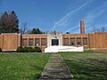
Former school in central West Mayfield
|
|
| Motto(s):
"A Nice Place to Live"
|
|

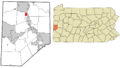
Location in Beaver County and the U.S. state of Pennsylvania.
|
|
| Country | United States |
| State | Pennsylvania |
| County | Beaver |
| Incorporated | 1923 |
| Government | |
| • Type | Borough Council |
| Area | |
| • Total | 0.80 sq mi (2.06 km2) |
| • Land | 0.80 sq mi (2.06 km2) |
| • Water | 0.00 sq mi (0.00 km2) |
| Elevation | 1,017 ft (310 m) |
| Population
(2020)
|
|
| • Total | 1,195 |
| • Density | 1,503.14/sq mi (580.37/km2) |
| Time zone | UTC-5 (Eastern (EST)) |
| • Summer (DST) | UTC-4 (EDT) |
| ZIP code |
15010
|
| Area code(s) | 724 |
| FIPS code | 42-83472 |
West Mayfield is a small town, called a 'borough,' located in the northern part of Beaver County, Pennsylvania, in the United States. In 2020, about 1,195 people lived there. It's considered part of the larger Pittsburgh metropolitan area, which means it's near the big city of Pittsburgh.
Contents
History of West Mayfield
The story of West Mayfield comes from a book called "West Mayfield History" by Edith Porter. This book was shared in a magazine called Milestones in 2002.
How West Mayfield Became a Borough
When Beaver County was first created, West Mayfield was part of a bigger area called South Beaver Township. Later, in 1816, it became part of Chippewa Township. Then, in 1887, it moved into the newly formed White Township.
Around that time, the area known as Mayfield was mainly a train station on the Pennsylvania Railroad. The station got its name from a nearby farm called Mayfield Cottage. So, West Mayfield was simply the area located west of that train station.
There were also smaller neighborhoods within West Mayfield. The Oakville area was around Rock Avenue, and another part was called West Park. You can still see these names today: there's a school called West Park, a road named Oakville Road (part of Route 251), and the community itself is called West Mayfield.
As more factories and businesses came to the area, and people needed better schools, West Mayfield decided to become its own separate town. It officially became a borough in 1923.
Early Life and Settlers
Most of West Mayfield is located along a long, steep road called 37th Street, which is part of Route 251. To the south of this road is a valley that used to be a farm and coal yard owned by the Harbison family.
Before industries arrived, the area was mostly farmland belonging to families like the Whites, Edwards, and Harbisons. There were only about a dozen houses and a small schoolhouse. 37th Street was a narrow dirt road. In winter, young people from nearby College Hill and Geneva College would have fun sledding and bobsledding down the snowy road.
Many of the first families who settled here had English, Irish, or Scottish backgrounds. John White, who came from Ireland around 1792, is thought to be the very first settler. John Edwards, who was born in Wales, bought land on 37th Street hill after 1852. Other early family names include Scranton, Patterson, and Ridings. Some families, like Schutte and Gumph, had German names.
Schools in West Mayfield
Edwards School: A Community Hub
The Edwards School was a small, red brick schoolhouse built around 1880. The Edwards family donated the land for it. John Edwards, who came from Wales, bought a farm on 37th Street hill after working in Pittsburgh and even in the gold fields of California.
The Edwards School was more than just a school. It was also a place for community meetings and events. At the end of each school year, it hosted a big picnic for students and their families. The Edwards family's home was also a warm and welcoming place for sledders to stop for snacks and a break. This school was the only one for miles around in the 1880s.
In 1924, even though West Mayfield had become a borough, the Edwards School was still managed by White Township. Forty students were expected to attend that year.
West Park and Liberty Schools
The West Park school building started being built in 1919 with four classrooms. In 1930, a new school, later named Liberty School, began construction. Liberty School was meant for grades 1-3, while West Park School would teach grades 4-6.
It's believed that the Edwards School continued to be used as a community building for a while. The Volunteer Fire Department even used it as a meeting place. In 1959, West Park School got a two-story addition. By 1969, another addition was completed, and Liberty School was no longer needed for classrooms. Today, the Liberty School building is the West Mayfield Municipal Building, where the borough government works.
Over the years, the number of students at West Park School changed. In 1970, about 255 students were expected, but by 1980, it was around 155.
High School Education
For many years, students from West Mayfield went to high school in Beaver Falls. Later, when the borough joined the Highland jointure (a group of school districts), students could go to Highland Junior High and Northwestern High School. Now, West Mayfield is part of the Blackhawk School District. Students attend Highland Middle School and then Blackhawk High School.
Churches in West Mayfield
St. Philomena Catholic Church
St. Philomena Catholic Church serves the West Mayfield community, even though it's located just outside the borough's borders. It also has a school that opened in 1958. The school added one grade each year until it offered all eight grades by 1964. Many students from West Mayfield attend this school.
West Mayfield Bible Baptist Church
A Christian School was started in West Mayfield in 1978. It teaches students from kindergarten through 12th grade. This school is located in the West Mayfield Community Church building, which is now known as the West Mayfield Bible Baptist Church.
This church began in 1948 because there was a need for Christian teaching for children in the West Mayfield Housing Project. It started with Sunday School classes for children and grew into a congregation. They built their current church building on High Street in 1967.
Church of the Living Christ
The Church of the Living Christ is a small chapel on Rock Avenue near 37th Street. It was built in 1910 in the Oakville area to hold a Sunday school. For many years, it was used by a Christian group connected to the College Hill Reformed Church. Later, a man named Ken Engle bought the building for Boy Scout meetings. The current congregation bought the chapel from Mr. Engle and has been holding services there for several years.
Industry and Growth
In the early days, West Mayfield had small industries like a scale factory and a key factory. Coal was also mined in Harbison Hollow. Big industrial growth started in 1899 when a tube-making company, now known as Babcock & Wilcox Company, moved into the area. Other factories followed, including Mayfield Foundry, which makes metal castings, and Standard Steel Specialty Company, which makes elevator parts.
As new factories were built, more homes were needed for workers and their families. So, farmlands slowly became neighborhoods with many houses. West Mayfield became a more crowded area compared to nearby townships like Chippewa or South Beaver. People from many different backgrounds came to West Mayfield for jobs.
Community Spirit
West Mayfield is known for its strong community spirit. It has an active Volunteer Fire Department. The local school also gets a lot of support from a great Parent-Teacher Organization (PTO). The PTO has helped the school by providing books for the library, equipment, and supporting school programs and field trips. Many children in West Mayfield play in Little League baseball clubs, and the community strongly supports them.
The "Hollow" is West Mayfield's main park and recreation area. It's located in Harbison Hollow and has a large flat space with three baseball fields, basketball and tennis courts, picnic areas, and playground equipment. It's also where the annual school picnic is held. Teachers and children often walk to the park, which is surrounded by wooded hillsides.
Geography of West Mayfield
West Mayfield is located in the north-central part of Beaver County, Pennsylvania. It covers about 0.8 square miles (2.06 square kilometers) of land.
The borough is home to a beautiful community park with a winding stream called Walnut Bottom Run. This stream eventually flows into the Beaver River.
Neighboring Areas
West Mayfield shares its borders with four other places:
- Big Beaver to the north
- Beaver Falls to the east
- White Township to the south
- Chippewa Township to the west
Population and People
| Historical population | |||
|---|---|---|---|
| Census | Pop. | %± | |
| 1930 | 876 | — | |
| 1940 | 963 | 9.9% | |
| 1950 | 1,768 | 83.6% | |
| 1960 | 2,201 | 24.5% | |
| 1970 | 2,152 | −2.2% | |
| 1980 | 1,712 | −20.4% | |
| 1990 | 1,312 | −23.4% | |
| 2000 | 1,187 | −9.5% | |
| 2010 | 1,239 | 4.4% | |
| 2020 | 1,195 | −3.6% | |
| 2021 (est.) | 1,181 | −4.7% | |
| U.S. Decennial Census | |||
According to the 2000 census, there were 1,187 people living in West Mayfield. Most of the people (about 97%) were White, with a smaller percentage being African American or other races.
There were 469 households, and about 30% of them had children under 18 living there. Most households (about 56%) were married couples. The average household had about 2.5 people.
The population was spread out by age:
- About 24.7% were under 18 years old.
- About 19.3% were 65 years or older.
The average age in West Mayfield was 40 years old.
The median income for a household in the borough was $36,324. This means that half of the households earned more than this amount, and half earned less. About 10.3% of the population lived below the poverty line.
Education
Children who live in West Mayfield attend schools in the Blackhawk School District. The schools that serve West Mayfield are:
- Patterson Primary School – for grades K–2
- Blackhawk Intermediate School – for grades 3–5
- Highland Middle School – for grades 6–8
- Blackhawk High School – for grades 9–12
Images for kids
-
Former school in central West Mayfield
-
Location in Beaver County and the U.S. state of Pennsylvania.
See also
 In Spanish: West Mayfield para niños
