West Rushville, Ohio facts for kids
Quick facts for kids
West Rushville, Ohio
|
|
|---|---|
|
Village
|
|

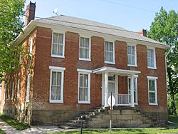
Joseph Ijams House, built 1810
|
|

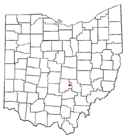
Location of West Rushville, Ohio
|
|

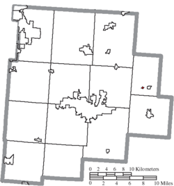
Location of West Rushville in Fairfield County
|
|
| Country | United States |
| State | Ohio |
| County | Fairfield |
| Area | |
| • Total | 0.07 sq mi (0.17 km2) |
| • Land | 0.07 sq mi (0.17 km2) |
| • Water | 0.00 sq mi (0.00 km2) |
| Elevation | 1,017 ft (310 m) |
| Population
(2020)
|
|
| • Total | 166 |
| • Density | 2,553.85/sq mi (988.51/km2) |
| Time zone | UTC-5 (Eastern (EST)) |
| • Summer (DST) | UTC-4 (EDT) |
| ZIP code |
43150
|
| Area code(s) | 740 |
| FIPS code | 39-84182 |
| GNIS feature ID | 2400142 |
West Rushville is a small village in Fairfield County, Ohio, United States. In 2020, about 166 people lived there.
Contents
History of West Rushville
West Rushville got its own post office in 1842. A post office is where you send and receive mail. It stayed open until 1996. The village was named West Rushville because it is located on the west side of a small stream called Little Rush Creek. This creek separates West Rushville from another village called Rushville.
Where is West Rushville?
The United States Census Bureau is a group that collects information about people and places in the U.S. According to them, West Rushville covers a total area of about 0.07 square miles (0.17 square kilometers). All of this area is land, with no water.
How Many People Live Here?
| Historical population | |||
|---|---|---|---|
| Census | Pop. | %± | |
| 1870 | 185 | — | |
| 1880 | 212 | 14.6% | |
| 1890 | 195 | −8.0% | |
| 1900 | 161 | −17.4% | |
| 1910 | 147 | −8.7% | |
| 1920 | 142 | −3.4% | |
| 1930 | 138 | −2.8% | |
| 1940 | 149 | 8.0% | |
| 1950 | 152 | 2.0% | |
| 1960 | 174 | 14.5% | |
| 1970 | 189 | 8.6% | |
| 1980 | 159 | −15.9% | |
| 1990 | 134 | −15.7% | |
| 2000 | 132 | −1.5% | |
| 2010 | 134 | 1.5% | |
| 2020 | 166 | 23.9% | |
| U.S. Decennial Census | |||
The 2010 Census
In 2010, a census (a count of all people) showed that 134 people lived in West Rushville. There were 51 households, which are groups of people living together. Out of these, 38 were families.
The village had about 1,914 people per square mile. There were 62 housing units, like houses or apartments. Most people, 97%, were White. About 3% were from two or more racial backgrounds. Less than 1% of the population was Hispanic or Latino.
About 39% of the households had children under 18 living there. More than half, 53%, were married couples. About 12% had a female head of the house with no husband. About 10% had a male head of the house with no wife. About 25% were non-families, meaning people living together who are not related.
The average household had 2.63 people. The average family had 3 people. The median age in the village was 36 years old. This means half the people were younger than 36, and half were older.
About 29% of the people were under 18 years old. About 9% were between 18 and 24. About 28% were between 25 and 44. About 25% were between 45 and 64. And about 9% were 65 years old or older. The village had slightly more males (50.7%) than females (49.3%).
Important Buildings
West Rushville is home to the main office for the Fairfield Union Local School District. This is where the schools in the area are managed.
The historic Joseph Ijams House is a very old building. It sits right in the middle of the village where roads cross. It was built around 1810. Long ago, it was a tavern, which is like an inn or restaurant, on an old road called Zane's Trace.
See also
 In Spanish: West Rushville (Ohio) para niños
 | George Robert Carruthers |
 | Patricia Bath |
 | Jan Ernst Matzeliger |
 | Alexander Miles |

