West Tisbury, Wiltshire facts for kids
Quick facts for kids West Tisbury |
|
|---|---|
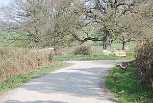
 Junction near Hatch House |
|
| Population | 573 (in 2011) |
| OS grid reference | ST916290 |
| Civil parish |
|
| Unitary authority |
|
| Ceremonial county | |
| Region | |
| Country | England |
| Sovereign state | United Kingdom |
| Post town | Salisbury |
| Postcode district | SP3 |
| Dialling code | 01747 |
| Police | Wiltshire |
| Fire | Wiltshire |
| Ambulance | Great Western |
| EU Parliament | South West England |
| UK Parliament |
|
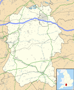
West Tisbury is a small area in southwest Wiltshire, England. It's a type of local area called a civil parish. This parish includes the southwestern part of the village of Tisbury. It stretches about 3.8 miles (6.1 km) to the west. Tisbury itself is about 13 miles (21 km) west of the city of Salisbury.
This area is made up of several small villages or hamlets. These include:
- East Hatch
- Kinghay
- Newtown
- Tuckingmill, which is just west of Tisbury. (Be careful not to confuse it with other places called Tuckingmill in Cornwall or Somerset!)
- West Hatch (Also, don't confuse this with another West Hatch in Somerset!)
The River Sem flows along most of the southern edge of the parish. This river is a branch of the River Nadder. The West of England Main Line railway, built in 1859, also follows the same path as the river.
West Tisbury has its own local government group called a parish council. This council is elected by the people living in the parish. The larger local government for the area is Wiltshire Council. This council handles most of the important local services.
Contents
A Look Back: West Tisbury's History
In the late 1500s, West Hatch was mostly just a few farms spread out. Even in 1773, there wasn't a clear village center, and it's still like that today. East Hatch was more settled back then. It even had a medieval chapel, though its exact location is now unknown. By the early 1800s, East Hatch had about 34 houses.
Until 1835, the land that is now West Tisbury was part of the larger Tisbury parish. Later, in 1986, some small parts of West Tisbury were moved to nearby areas. These included parts that went to East Knoyle and Tisbury itself. The part that went to Tisbury included houses built in the 1970s.
A school was built in Newtown in 1846. It served the children of the area until it closed in 1931.
The number of people living in West Tisbury has changed over time. In 1841, there were 734 residents. This number went down to 653 by 1861. However, it then increased to 855 by 1871. This rise happened because people moved from East Tisbury after a new workhouse was built in West Tisbury. After that, the population slowly went down, reaching 429 by 1971.
Important Buildings to See
There are a couple of very old and important buildings in West Tisbury.
Pythouse: A Grand Country House
Pythouse is a large country house located near Newtown. It's so important that it's listed as a Grade II* listed building. The first version of the house was built around 1725. Then, in 1805, it was rebuilt for a politician named John Benett.
Hatch House: A Historic Home
Nearby is Hatch House, which dates back to the 1600s. It was changed in 1908 by an architect named Detmar Blow. Hatch House is also a Grade II* listed building, meaning it's very special.
St Andrew's Church: A Church Transformed
St Andrew's church in Newtown was built in 1911. It was designed by Edward Doran Webb. The church was built using stone from an older church that was in the grounds of Pythouse. St Andrew's was once a small church connected to Tisbury's main church. However, it was no longer needed as a church in 1975. Today, it has been changed into a home.
 | DeHart Hubbard |
 | Wilma Rudolph |
 | Jesse Owens |
 | Jackie Joyner-Kersee |
 | Major Taylor |


