
Westway (London) facts for kids
The Westway is a 4-kilometre (2.5-mile) elevated road in West London. It's part of the A40 main road and connects Paddington in the east to North Kensington in the west. This important road helps link central London to the western suburbs.
The Westway was built between 1962 and 1970. It was meant to connect to a big motorway plan for London called the London Ringways. When it opened, it was called the A40(M). It was the first big elevated road project in London. However, many people were unhappy because it caused a lot of noise and meant many homes had to be knocked down. Protests against new roads grew after it opened. In 2000, the Westway was changed from a motorway to a regular road. Today, it's a well-known landmark in London and has appeared in many songs and stories.
Contents
The Westway's Path

The Westway is 4 kilometres (2.5 miles) long. It runs through the City of Westminster and the Royal Borough of Kensington and Chelsea. At its eastern end, the Westway starts near the Marylebone Flyover. This flyover helps traffic go over busy junctions.
As you head west, the Westway goes up as it passes Paddington Green. It crosses the Grand Union Canal and then runs next to the Great Western Main Line railway. Near Westbourne Park, the road turns southwest and crosses the railway again. It then runs alongside the London Underground's Hammersmith & City line until Ladbroke Grove station.
The road then turns back to an east-west direction. It goes over a large roundabout junction with the West Cross Route. It also crosses the Central line and Wood Lane. Finally, it returns to ground level and connects to Western Avenue. From the elevated road, you can see famous buildings like Trellick Tower and the site of Grenfell Tower.
Between 2007 and 2011, part of the Westway was a "free through route." This meant drivers could use it to cross the London Congestion Charge Zone without paying a fee.
Why the Westway Was Built

The Westway was built as an extension of Western Avenue. Its main purpose was to connect to Ringway 1. This was the inner circle of the London Ringways network. The Ringways were a big plan for a network of fast roads around London. The idea was to control traffic flow.
This plan had been developing since before World War II. It became a big project in the 1960s by the Greater London Council (GLC). The plan involved building many motorway-standard roads across the city. This would have meant knocking down a lot of buildings.
The large roundabout where the Westway meets the West Cross Route was built to be extended. There were even special parts built for future connections. This was in case the West Cross Route was continued further north.

How the Westway Was Built

The Greater London Council (GLC) paid for most of the Westway. The main company that built it was John Laing & Sons.
The road was designed to have three lanes in each direction. But in 1966, it was updated to include hard shoulders for safety. The builders chose a route that followed existing railway lines. This made it easier to build. An elevated road was also cheaper and needed less land.
However, building an eight-lane elevated road through a busy area meant many buildings had to be cleared. This was especially true west of Westbourne Park. Many roads were cut off or demolished to make space for the concrete structures. Some parts of the road even passed very close to people's homes.
The government started buying properties in 1962. About 3,356 people needed new homes. The construction also caused a lot of disruption. Heavy trucks moved materials to the site and took away waste. The road was mostly built from special concrete sections. These sections were made off-site and then moved into place.
Prince Charles visited the construction in 1968 when he was 19. The Westway opened on July 28, 1970. It cost £30 million. When it opened, it was the largest continuous elevated structure in Europe. It even had advanced features like heating grids on slopes to stop ice from forming. After it was finished, there was a lot of empty land under the motorway.
Impact on the Community

The Westway was planned before people thought much about how roads affect the environment. It caused a lot of arguments because of its impact on local communities. At the opening ceremony, protesters booed the government ministers. A group of squatters even moved into empty houses nearby. They called their area "Frestonia" as a protest.

People living on Acklam Road, which was next to the Westway, hung a big banner. It said, "Get us out of this hell! Rehouse us now!" They complained about the noise from the road. Soon after the road opened, some residents planned to block it to protest the noise.
In 1970, the Westway was closed for an hour because 80 protesters marched on it. Four people were arrested. The government later announced that more homes would be bought and demolished for a new school. By 1972, it was estimated that about 5,000 families had lost their homes for each mile of the Westway built.
The Westway project has been criticized for its negative effects on local communities and housing. It helped lead to more protests against new roads. One group called the Westway "one of the insensitive and socially unacceptable examples of motorways."
The North Kensington Amenity Trust (now Westway Development Trust) was started in 1971. Its goal was to use the land under the Westway for the local community. Since 2000, a charity called Urban Eye has worked to clean, paint, and light up the areas under the flyover. This has made them look better and feel safer.
What Happened Next
Because of the high costs and public opposition to the Westway, most of the big London Ringways plan was cancelled in 1973. Only a few parts were built, including the Westway, the West Cross Route, and the East Cross Route. Other parts of the Ringway network were later built as regular roads. For example, the M11 link road from Hackney to Redbridge also caused major protests.
The Westway stopped being a motorway in May 2000. This happened when the responsibility for main roads in Greater London moved to the Greater London Authority. In 2013, the Mayor of London, Boris Johnson, announced plans to rebuild parts of the Westway. The idea was to add a separate cycle path by making the road smaller for cars. However, these plans were stopped in 2016.
Images for kids
-
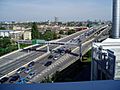
The Westway looking east. On the horizon is Trellick Tower.
-
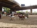
People have tried to make the land under the Westway useful again.


