Westwood, Boyd County, Kentucky facts for kids
Quick facts for kids
Westwood, Kentucky
|
|
|---|---|
| Country | United States |
| State | Kentucky |
| County | Boyd |
| Area | |
| • Total | 3.83 sq mi (9.92 km2) |
| • Land | 3.74 sq mi (9.68 km2) |
| • Water | 0.10 sq mi (0.25 km2) |
| Elevation | 682 ft (208 m) |
| Population
(2020)
|
|
| • Total | 4,387 |
| • Density | 1,174.25/sq mi (453.33/km2) |
| Time zone | UTC-5 (Eastern (EST)) |
| • Summer (DST) | UTC-4 (EDT) |
| ZIP code |
41101 & 41102
|
| Area code(s) | 606 |
| FIPS code | 21-82146 |
| GNIS feature ID | 0506507 |
Westwood is a special kind of community in Boyd County, Kentucky, United States. It's called a "census-designated place" (CDP). This means it's an area that looks like a town but isn't officially a city with its own local government.
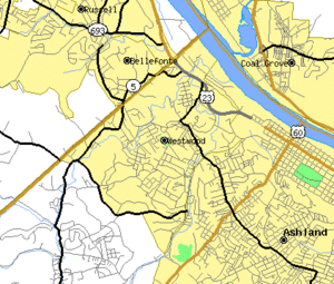
In 2020, about 4,387 people lived in Westwood. It's like a neighbor to the city of Ashland. Westwood and Ashland are very connected. They even share the same ZIP code and bus system.
Westwood is located on land that is mostly flat to slightly hilly. It sits just west of the Ohio River. The flat top of the hill where Westwood is built is quite unusual for eastern Kentucky. This flat area was formed a very long time ago by an ancient river called the Teays River. This old river flowed in the opposite direction of the Ohio River today! Westwood is also part of the larger Huntington–Ashland metropolitan area.
Contents
History of Westwood
Westwood started to be developed after 1920. It was planned as a new neighborhood for the city of Ashland. However, the people living in Westwood wanted to stay independent. Because of this, Westwood has never officially become part of Ashland.
Many of the first homeowners in Westwood worked for a nearby steel company. This company was called Armco Steel, which is now known as AK Steel. Most of Westwood was built between 1920 and 1950. Some new buildings have been added since then. Even though Westwood grew a lot, it was never officially made into a city. It is one of the largest communities in Kentucky that is not an official city.
Geography and Location
Westwood is located at 38°28′57″N 82°40′41″W / 38.48250°N 82.67806°W.
The United States Census Bureau says that Westwood covers a total area of about 9.9 square kilometers (3.8 square miles). Most of this area, about 9.7 square kilometers (3.7 square miles), is land. The rest, about 0.2 square kilometers (0.1 square miles), is water.
Westwood is mostly built on a flat ridge. This ridge is located to the west of the Ohio River. The southern edge of Westwood touches the city limits of Ashland. To the north, its boundary is a place called Hood's Creek.
The flat land where Westwood sits was created by the ancient Teays River. This river's path changed about two million years ago. This happened because of large ice formations called glaciers. This is why you can see many flat hilltops in Boyd and Greenup counties. You can even see them clearly in satellite pictures! Outside of this old river bed, the land is made of "ridges and valleys." This is typical for most of the Eastern Kentucky area.
Population and People
| Historical population | |||
|---|---|---|---|
| Census | Pop. | %± | |
| 2000 | 4,888 | — | |
| 2010 | 4,746 | −2.9% | |
| 2020 | 4,387 | −7.6% | |
| U.S. Decennial Census | |||
Let's look at the people who live in Westwood. In the year 2000, there were 4,888 people living there. These people lived in 2,004 households, and 1,468 of these were families.
Most of the people in Westwood in 2000 were White (98.20%). A small number were African American (0.47%), Native American (0.08%), or Asian (0.37%). Some people (0.84%) were from two or more races. About 0.49% of the population identified as Hispanic or Latino.
About 26.6% of the households had children under 18 living with them. Most households (58.0%) were married couples living together. About 11.3% of households had a female head with no husband present.
The average household had 2.43 people, and the average family had 2.84 people.
The population in 2000 was spread out by age. About 20.9% were under 18 years old. About 9.0% were between 18 and 24. The largest group, 27.0%, was between 45 and 64 years old. About 16.9% of the people were 65 years old or older. The average age in Westwood was 41 years.
The median income for a household in 2000 was $29,394. For families, the median income was $36,094. The average income per person in Westwood was $18,455. About 9.1% of families and 14.2% of all people lived below the poverty line. This included 20.0% of those under 18 and 7.6% of those 65 or older.
Education in Westwood
Westwood has its very own school system! It is called the Fairview Independent School District. This district serves the students living in Westwood.
See also
 In Spanish: Westwood (condado de Boyd) para niños


