
White Mountains (Arizona) facts for kids
Quick facts for kids White Mountains (Arizona) |
|
|---|---|

Mount Baldy
|
|
| Highest point | |
| Elevation | Mount Baldy 11,420 ft (3,480 m) 33°54′22″N 109°33′46″W / 33.90611°N 109.56278°W |
| Geography | |

Position of White Mountains inside Arizona
|
|
| Parent range | Arizona transition zone–Colorado Plateau |
The White Mountains are a beautiful mountain range in eastern Arizona. They are close to the border with New Mexico. These mountains are part of a larger area called the Colorado Plateau. This plateau also stretches into Utah, New Mexico, and Colorado.
Many towns are near the White Mountains. These include Show Low, Pinetop-Lakeside, Greer, and Springerville. A large part of the mountains is inside the Fort Apache Indian Reservation.
Contents
Exploring the White Mountains
The White Mountains are a great place to visit. They offer many fun activities. The highest point in the range is Mount Baldy. It stands at about 11,400 feet (3,475 m) tall.
Rivers and Lakes
Water from the mountains flows in two main directions. To the south, it feeds into the Salt River. To the north, it flows into the Little Colorado River. There are also several small lakes scattered throughout the mountains. These lakes add to the natural beauty of the area.
National Forest Land
A big part of the White Mountains is outside the reservation. This area is part of the Apache-Sitgreaves National Forests. This national forest is a protected space. It is managed to keep the natural environment healthy.
Images for kids
-
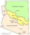
Physiographic regions of Arizona
-
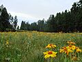
Wildflowers near Alpine, Arizona


See also
 In Spanish: Sierra Blanca (Arizona) para niños
