Whitney Point, New York facts for kids
Quick facts for kids
Whitney Point, New York
|
|
|---|---|

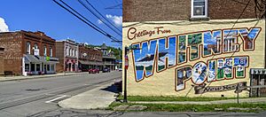
Main Street
|
|

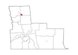
Map highlighting Whitney Point's location within Broome County.
|
|
| Country | United States |
| State | New York |
| County | Broome |
| Town | Triangle |
| Area | |
| • Total | 1.11 sq mi (2.88 km2) |
| • Land | 1.04 sq mi (2.70 km2) |
| • Water | 0.07 sq mi (0.18 km2) |
| Elevation | 958 ft (292 m) |
| Population
(2020)
|
|
| • Total | 960 |
| • Density | 920.42/sq mi (355.54/km2) |
| Time zone | UTC-5 (Eastern (EST)) |
| • Summer (DST) | UTC-4 (EDT) |
| ZIP code |
13862
|
| Area code(s) | 607 |
| FIPS code | 36-81831 |
| GNIS feature ID | 0971191 |
Whitney Point is a small village located in Broome County, New York, United States. In 2020, about 960 people lived there. It is part of the larger Binghamton area. The village got its name from early settlers, Thomas and William Whitney.
Whitney Point is in the southwestern part of a larger area called the town of Triangle. It is located north of the city of Binghamton.
History of Whitney Point
People first started settling in the Whitney Point area around 1791. The village really began to grow after the Whitney family arrived around 1800.
The village of Whitney Point was officially formed in 1871. It was first called "Whitney's Point." A big fire nearly destroyed the village in 1897. After serious floods in 1935 and 1936, people started building a dam north of the village. This dam was built on the Otselic River and was finished in 1942. Later, it was decided to keep water in the dam all year round for fun activities like boating and fishing. This created the Whitney Point Lake, also known as the Whitney Point Reservoir.
Since 1874, Whitney Point has been the home of the Broome County Fair, a popular event for the community. For a short time around 1902, a car called the Whitney automobile was made in this village.
Grace Episcopal Church is an important building in Whitney Point. It was added to the National Register of Historic Places in 1998 because of its historical value. The village has a fun slogan that refers to its dam: "best town by a dam site."
Geography of Whitney Point
Whitney Point is located at coordinates 42.330084 degrees North and -75.970091 degrees West.
The village covers a total area of about 2.9 square kilometers (1.11 square miles). Most of this area, about 2.7 square kilometers (1.04 square miles), is land. The rest, about 0.2 square kilometers (0.07 square miles), is water, making up about 6.31% of the total area.
Whitney Point is situated along the Tioughnioga River, right where it meets the Otselic River.
Several important roads meet in the village. These include NY 26, NY 79, NY 206, and US 11. The major highway Interstate 81 also runs along the western side of the village, with an exit at Exit 8 for easy access.
Population Information
| Historical population | |||
|---|---|---|---|
| Census | Pop. | %± | |
| 1870 | 480 | — | |
| 1880 | 818 | 70.4% | |
| 1890 | 842 | 2.9% | |
| 1900 | 807 | −4.2% | |
| 1910 | 744 | −7.8% | |
| 1920 | 665 | −10.6% | |
| 1930 | 639 | −3.9% | |
| 1940 | 733 | 14.7% | |
| 1950 | 883 | 20.5% | |
| 1960 | 1,049 | 18.8% | |
| 1970 | 1,058 | 0.9% | |
| 1980 | 1,093 | 3.3% | |
| 1990 | 1,054 | −3.6% | |
| 2000 | 965 | −8.4% | |
| 2010 | 964 | −0.1% | |
| 2020 | 960 | −0.4% | |
| U.S. Decennial Census | |||
According to the census from 2000, there were 965 people living in Whitney Point. The village had 397 households and 244 families. The population density was about 966 people per square mile (373 people per square kilometer).
The average age of people in the village was 37 years old. About 28.3% of the population was under 18 years old.
See also
 In Spanish: Whitney Point para niños
 | Toni Morrison |
 | Barack Obama |
 | Martin Luther King Jr. |
 | Ralph Bunche |


