Widgee facts for kids
Quick facts for kids WidgeeQueensland |
|||||||||||||||
|---|---|---|---|---|---|---|---|---|---|---|---|---|---|---|---|

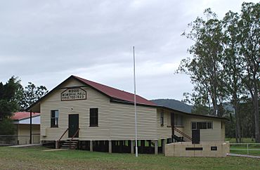
Soldiers' Memorial hall
|
|||||||||||||||
| Population | 862 (2021 census) | ||||||||||||||
| • Density | 4.358/km2 (11.29/sq mi) | ||||||||||||||
| Postcode(s) | 4570 | ||||||||||||||
| Area | 197.8 km2 (76.4 sq mi) | ||||||||||||||
| Time zone | AEST (UTC+10:00) | ||||||||||||||
| Location | |||||||||||||||
| LGA(s) | Gympie Region | ||||||||||||||
| State electorate(s) | Gympie | ||||||||||||||
| Federal Division(s) | Wide Bay | ||||||||||||||
|
|||||||||||||||
Widgee is a small country area, also known as a locality, in the Gympie Region of Queensland, Australia. In 2021, about 862 people lived in Widgee. It's a place where people live on farms and enjoy the quiet countryside.
Contents
Widgee's Past: A Look at History
How Widgee Got Its Name
The name Widgee is thought to come from the Aboriginal words Witchee Witchee. These words mean listen or hark, which is like saying "pay attention!"
Early Farms and Land
In 1887, a large area of land, about 43,000 acres, was made available from the Widgee Widgee pastoral run. This land was offered for people to choose and set up small farms. This happened on April 17, 1887.
Widgee's First Schools
The first school in Widgee, called Widgee Provisional School, opened on July 11, 1892. It likely started in a temporary spot. A new school building was planned in 1893. On January 1, 1909, it became Widgee State School. A new building for the school was built in 1913. However, this school closed in 1921. It was located near Station Creek.
In 1912, the Queensland Government offered more land for farming. They made 48 farm lots available near Widgee Mountain and Widgee Creek. These farms were good for dairy farming and general crops.
The Soldiers' Memorial Hall
The Widgee Soldiers' Memorial Hall was officially opened on March 31, 1923. About 300 people came to the opening. This hall was important because it allowed the school to reopen. Students used the hall for classes until 1938. That year, a new school building was built right next to the hall.
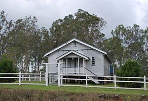
St Vincent de Paul Catholic Church
On March 27, 1938, a special ceremony took place for a new Catholic church in Widgee. The land for the church was given by Mrs W. Power. The church was officially opened on September 25, 1938. About 500 people attended the opening. The church was made of timber and could seat 100 people. It cost about £674 to build.
People Living in Widgee
The number of people living in Widgee has changed over the years:
- In 2011, Widgee had 788 people.
- In 2016, the population grew slightly to 794 people.
- By 2021, the population of Widgee was 862 people.
Places of Historical Importance
Widgee has some places that are listed for their historical value. These are called heritage-listed sites. One such place is:
- Wodonga House, located on Woolooga Road, Upper Widgee.
Learning in Widgee
Widgee State School
Widgee State School is a government primary school. It teaches students from Prep to Year 6. Both boys and girls attend this school. It is located at 2156 Gympie-Woolooga Road. In 2017, the school had 52 students. There were 4 teachers and 6 other staff members helping the students.
High School Options
There are no high schools directly in Widgee. Students who want to go to secondary school usually travel to James Nash State High School in Gympie.
Community Spots in Widgee
St Vincent de Paul Catholic Church
The St Vincent de Paul Catholic Church is located at the corner of Gympie Woolooga Road and Little Widgee Road. It is a place for worship and community gatherings.
The Soldiers' Memorial Hall
The Soldiers' Memorial Hall is at 2148 Gympie Woolooga Road. Inside the hall, there is an honour board. This board remembers the people from Widgee who served in World War I, World War II, and the Vietnam War. Outside the hall, there is also a war memorial to honor those who served.
Widgee Showgrounds
The Widgee Showgrounds are located at 22 Upper Widgee Road. This is a place where local events and shows are held. The Widgee & District Pony Club also uses these showgrounds for their activities.


