
Winchester, Ohio facts for kids
Quick facts for kids
Winchester, Ohio
|
|
|---|---|
|
Village
|
|

Dr. A.C. Lewis House, listed on the National Register of Historic Places, located at 103 E. South Street in Winchester
|
|

Location in Adams County and the state of Ohio.
|
|
| Country | United States |
| State | Ohio |
| County | Adams |
| Area | |
| • Total | 2.63 sq mi (6.81 km2) |
| • Land | 2.61 sq mi (6.76 km2) |
| • Water | 0.02 sq mi (0.05 km2) |
| Elevation | 906 ft (276 m) |
| Population
(2010)
|
|
| • Total | 1,051 |
| • Estimate
(2012)
|
1,045 |
| • Density | 402.7/sq mi (155.5/km2) |
| Time zone | UTC-5 (Eastern (EST)) |
| • Summer (DST) | UTC-4 (EDT) |
| ZIP code |
45697
|
| Area code(s) | 937 |
Winchester is a small village located in Adams County, Ohio. In 2010, about 1,051 people lived there. The area around the village is also called Winchester Township.
Two important roads pass near Winchester. State Route 136 goes right through the village. Close by is Ohio State Route 32, also known as the Appalachian Highway. This four-lane highway connects Winchester to the city of Cincinnati. There is a traffic light where Route 32 and Route 136 meet.
Contents
Winchester's Location and Size
Winchester is found at coordinates 38.940248 degrees North and 83.653174 degrees West.
The United States Census Bureau says that the village covers a total area of about 2.63 square miles (6.81 square kilometers). Most of this area, 2.61 square miles (6.76 square kilometers), is land. Only a tiny part, 0.02 square miles (0.05 square kilometers), is water.
People Living in Winchester
| Historical population | |||
|---|---|---|---|
| Census | Pop. | %± | |
| 1870 | 416 | — | |
| 1880 | 550 | 32.2% | |
| 1900 | 796 | — | |
| 1910 | 927 | 16.5% | |
| 1920 | 913 | −1.5% | |
| 1930 | 821 | −10.1% | |
| 1940 | 798 | −2.8% | |
| 1950 | 690 | −13.5% | |
| 1960 | 788 | 14.2% | |
| 1970 | 760 | −3.6% | |
| 1980 | 1,080 | 42.1% | |
| 1990 | 978 | −9.4% | |
| 2000 | 1,025 | 4.8% | |
| 2010 | 1,051 | 2.5% | |
| 2015 (est.) | 1,035 | −1.5% | |
|
|
|||
Population in 2010
According to the census from 2010, there were 1,051 people living in Winchester. These people lived in 420 households, and 273 of these were families. The village had about 403 people per square mile (155.5 per square kilometer). There were 462 homes, with about 177 homes per square mile (68.3 per square kilometer).
Most of the people in the village were White (98.4%). A small number were African American (0.2%), Native American (0.5%), or from other races (0.3%). About 0.7% of people were of two or more races. People who identified as Hispanic or Latino made up 1.0% of the population.
In Winchester, 34% of households had children under 18 living with them. About 45.7% were married couples living together. Some households had a female head without a husband (13.1%), or a male head without a wife (6.2%). About 35% of households were not families.
The average age of people in the village was 35.9 years. About 27.3% of residents were under 18 years old. About 9.3% were between 18 and 24. People aged 25 to 44 made up 25.9% of the population. Those aged 45 to 64 were 22%, and 15.6% were 65 years or older. The population was almost evenly split between males (49%) and females (51%).
A Look at Winchester's Past
Winchester was first planned out in 1815 by a man named Joseph Darlinton. He named the new village after his old hometown, Winchester, Virginia.
There is also an important historical site in Winchester called the Dr. A. C. Lewis House. This house was built between 1845 and 1848. Dr. Lewis was the first doctor to live in Winchester. He was known for being an abolitionist, which means he was against slavery. He used his house as a safe place for people escaping slavery on the Underground Railroad.
Images for kids
-
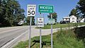
Winchester corporation limit sign
-
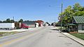
Looking north on Main Street (Ohio Highway 136) in Winchester
-
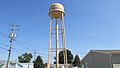
Winchester water tower
-
Fancy's Famous Pizza
-
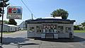
Reid's Dairy Bar
-
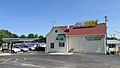
Subway store
-
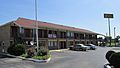
Budget Host Inn
-
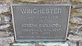
Joseph Darlinton Bicentennial Marker
-
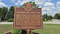
Winchester Ohio Historical Marker
-
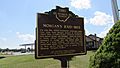
Morgan's Raid 1863 (reverse side)
-
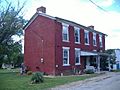
Dr. A. C. Lewis House


