
Wisconsin Point Light facts for kids
 |
|
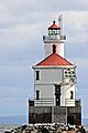
| Wisconsin Point Lighthouse | |

Wisconsin Point Light
Location in Wisconsin
|
|
| Location | Superior Wisconsin |
|---|---|
| Coordinates | 46°42′36.5″N 92°00′23″W / 46.710139°N 92.00639°W |
| Year first constructed | 1913 |
| Year first lit | 1913 |
| Automated | 1970 |
| Foundation | Concrete pier |
| Construction | Concrete |
| Tower shape | Cylindrical, atop square (rounded corners) keeper's house |
| Markings / pattern | White with red lantern, red roof on house |
| Height | 56 feet (17 m) |
| Focal height | 70 feet (21 m) |
| Original lens | Fourth order Fresnel lens |
| Current lens | DCB 24 Carlisle & Finch Aerobeacon |
| Range | 21 nautical miles (39 km; 24 mi) |
| Characteristic | Green flashing, 5 s |
| Fog signal | HORN: 1 blast ev 30s (3s bl); operates from May 1 to October 20 |
| ARLHS number | USA-829 |
| USCG number | 7-15595 |
The Wisconsin Point Light is a lighthouse located near Superior, in Douglas County, Wisconsin, United States. It stands on Wisconsin Point, a long strip of land that helps protect the harbor. This lighthouse helps guide ships safely into the busy Duluth–Superior Harbor.
Contents
What is the Wisconsin Point Light?
This lighthouse has a light and a fog horn building. It sits on a sandbar that is about 10-mile (16 km) long. This sandbar stretches between the ports of Duluth and Superior. It helps make the Duluth–Superior Harbor one of the safest harbors in the world.
A Special Sandbar
This sandbar is thought to be the longest freshwater sandbar in the world. It is split in the middle by an opening where the lighthouse stands. The part of the sandbar on the Minnesota side is called "Minnesota Point" (also known as Park Point). The part on the Wisconsin side is called "Wisconsin Point." The lighthouse was added to the National Register of Historic Places in 2007. It is 70 feet (21 m) tall.
History of the Lighthouse
The Wisconsin Point Light was built in 1913. It has been an important guide for ships for over a hundred years. It is still an active navigation aid today. The United States Coast Guard calls it the South Breakwater Light.
How the Light Changed
The lighthouse originally used a special lens called a Fresnel lens, made in Paris in 1890. This lens helped make the light very bright and focused. Later, this old lens was replaced with a newer, more modern light called a DCB-224 aero beacon. This new light was made by the Carlisle & Finch Company.
What Happened to the Lighthouse?
The lighthouse is located on the southern breakwall of the Superior Harbor entry. The Saint Louis River flows into Lake Superior through this area. In July 2019, the main part of the lighthouse was put up for sale online. However, the breakwater it sits on and the navigation equipment inside will always belong to the U.S. Government.
Images for kids
-
Rear view of Wisconsin Point Light house

