Wishram village facts for kids
Quick facts for kids |
|
|
Wishram Indian Village Site
|
|

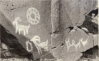
Petroglyphs at the village site.
|
|
| Lua error in Module:Location_map at line 420: attempt to index field 'wikibase' (a nil value). | |
| Location | Klickitat County, Washington, USA |
|---|---|
| Nearest city | The Dalles, Oregon |
| Area | 2,930 acres (11.9 km2) |
| NRHP reference No. | 72001278 |
| Added to NRHP | March 16, 1972 |
The Wishram Village, known as nixlúidix to its people, was an important Native American settlement. It was used in both summer and winter. This village was located along the Columbia River in Washington, United States. It was home to the Upper Chinook people. Many experts believe it was the largest Chinook village from ancient times. Today, the site is part of Columbia Hills State Park.
Contents
A Long History of the Wishram Village
The Wishram Village was located near a place called Five Mile Rapids. This spot was at the very eastern edge of the lands where Chinookan people lived. Scientists who study old sites, called archaeologists, think people lived here for about 10,000 years! That's a very long time.
A Busy Trading Center
The village was a major trading hub for many different Native American tribes. It connected tribes from the Pacific Coast with those living in the interior Northwest. People from nearby Yakama tribes visited often. Even tribes from far away, like the Nez Perce, traveled here. They came to trade many things, including fish, berries, animal skins, and buffalo products.
Famous Visitors: Lewis and Clark
The famous explorers Lewis and Clark visited the Wishram Village twice. They first came in October 1805 during their journey west. They returned in April 1806 on their way back east. During their first visit, they thought about 600 people lived there. On their second visit, they estimated around 1,000 people.
Clark wrote in his journals that he saw about 20 wooden houses. These houses were near a special man-made earth mound called Wakemup Mound.
Later Visits and Changes
In July 1841, another group of explorers, the United States Exploring Expedition, visited. United States Navy Lieutenant Charles Wilkes described the village. He noted it had forty lodges (homes) and about 400 people living there.
Around 1860, many Wishram residents started moving. They went to the Yakama Indian Reservation because of treaties signed in 1855. However, Native Americans were still allowed to use the Wishram site for fishing. The village at this site was known as Spearfish until 1957. That year, the area was flooded when The Dalles Dam was built.
What is Wakemap Mound?
Wakemap Mound is a large earth mound at the Wishram Village site. It is about 350 feet (107 meters) long and 270 feet (82 meters) wide. It is also about 20 feet (6 meters) deep. Today, this mound is surrounded by water. This happened because of the construction of The Dalles Dam.]]]

