Wonalancet, New Hampshire facts for kids
Quick facts for kids
Wonalancet, New Hampshire
|
|
|---|---|

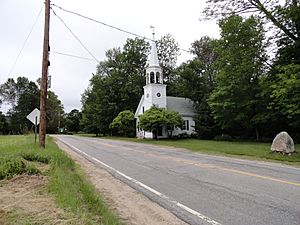
Wonalancet Union Chapel in the center of the village
|
|
| Country | United States |
| State | New Hampshire |
| County | Carroll |
| Town | Tamworth |
| Elevation | 1,099 ft (335 m) |
| Time zone | UTC-5 (Eastern (EST)) |
| • Summer (DST) | UTC-4 (EDT) |
| ZIP code |
03897
|
| Area code(s) | 603 |
| GNIS feature ID | 872963 |
Wonalancet is a small, special place located in the northwestern part of Tamworth, a town in Carroll County, New Hampshire. It's known as an "unincorporated community," which means it's a small area that doesn't have its own local government like a city or town. Instead, it's part of the larger town of Tamworth.
Wonalancet is especially popular with people who love the outdoors. It's a gateway to the beautiful White Mountains, offering many exciting hiking trails.
Contents
History of Wonalancet
How Wonalancet Got Its Name
The village of Wonalancet is named after a very important person from history. He was a 17th-century Pennacook sachem named Wonalancet. A sachem was a leader or chief among some Native American tribes, like the Pennacook people who lived in this area long ago. Naming the village after him honors his legacy.
Exploring Wonalancet
Hiking Adventures
Wonalancet is a fantastic spot for hikers. Many popular trails that lead into the Sandwich Range of the White Mountains start here. One well-known area is called Ferncroft. It's just a short drive from Wonalancet and serves as a main starting point for many mountain adventures.
Unique Postal Code
Even though Wonalancet is part of Tamworth, it has its own special ZIP code, which is 03897. This helps mail get to the right place in this unique community.
 | Madam C. J. Walker |
 | Janet Emerson Bashen |
 | Annie Turnbo Malone |
 | Maggie L. Walker |


