Worthington, Pennsylvania facts for kids
Quick facts for kids
Worthington, Pennsylvania
|
|
|---|---|
|
Borough
|
|

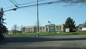
Worthington-West Franklin Municipal Complex
|
|

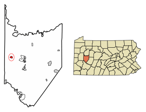
Location of Worthington in Armstrong County, Pennsylvania.
|
|
| Country | United States |
| State | Pennsylvania |
| County | Armstrong |
| Settled | 1811 |
| Incorporated | 1855 |
| Government | |
| • Type | Borough council |
| Area | |
| • Total | 0.69 sq mi (1.78 km2) |
| • Land | 0.69 sq mi (1.78 km2) |
| • Water | 0.00 sq mi (0.00 km2) |
| Elevation | 1,120 ft (340 m) |
| Population
(2020)
|
|
| • Total | 594 |
| • Estimate
(2019)
|
589 |
| • Density | 856.10/sq mi (330.71/km2) |
| Time zone | UTC-5 (Eastern (EST)) |
| • Summer (DST) | UTC-4 (EDT) |
| Zip code |
16262
|
| FIPS code | 42-86560 |
Worthington is a small town, also known as a borough, located in Armstrong County, Pennsylvania, United States. In 2020, about 594 people lived there.
Contents
History of Worthington
Worthington was first planned out by Judge James Barr between 1843 and 1844. He picked this spot because two important travel routes met nearby. One route went from Indiana, Pennsylvania to Butler, Pennsylvania. The other went from Freeport, Pennsylvania to Emlenton, Pennsylvania. These routes were used by stagecoaches, which were like early buses.
The town officially became a borough in 1855. As Worthington grew, its people made money from farming and small factories. In the 1970s, most of the factories closed. Today, farming is still important in the area. Some small companies that make tools and dies also remain. The region also has natural resources like coal, natural gas, and other minerals.
In the 1800s, a man named Peter Graff I owned the main industries. These included an iron furnace and a woolen mill. Later, other businesses came to Worthington. These included making tile blocks and clay pipes, aluminum ladders, and special tools. People also mined limestone and even grew mushrooms underground!
The first people to settle in Worthington came from eastern Pennsylvania. Others were immigrants from places like Scotland, Ireland, Germany, and England. In the early 1900s, more groups of people arrived.
Today, Worthington has four Protestant churches. It also has a community park, a public library, and other local groups. The town's community center and municipal complex are in the building that used to be the Junior/Senior High School. The fire hall helps both Worthington and West Franklin Township.
Worthington and West Franklin Township
Worthington borough and West Franklin Township often work together. They share services like water and sewage. Because of this, people sometimes call both areas "Worthington." They even share the same zip code, 16262.
The old high school, which was called Worthington-West Franklin Jr./Sr. High School, was actually outside the borough. Its team mascot was the Bison, and the school colors were green and white. The school closed around 1984. Students then went to Kittanning High School. That school also closed in 2015, along with two others, to form the new Armstrong High School.
Worthington P.O. (which means Post Office) was shown on a map of Armstrong County in 1876.
Geography of Worthington
Worthington is located in the western part of Armstrong County. Its exact location is 40°50′17″N 79°37′58″W / 40.838123°N 79.632685°W.
U.S. Route 422 is a four-lane highway called the Benjamin Franklin Highway. It goes through the southern part of Worthington. This highway leads about 7 miles (11 km) east to Kittanning, Pennsylvania. It also goes about 15 miles (24 km) west to Butler, Pennsylvania. The borough also reaches west into the valley of Buffalo Creek. This creek flows into the Allegheny River.
The United States Census Bureau says that Worthington covers a total area of about 0.69 square miles (1.8 km2). All of this area is land, with no water.
Population Changes
| Historical population | |||
|---|---|---|---|
| Census | Pop. | %± | |
| 1860 | 213 | — | |
| 1870 | 216 | 1.4% | |
| 1880 | 186 | −13.9% | |
| 1890 | 246 | 32.3% | |
| 1900 | 398 | 61.8% | |
| 1910 | 436 | 9.5% | |
| 1920 | 440 | 0.9% | |
| 1930 | 661 | 50.2% | |
| 1940 | 600 | −9.2% | |
| 1950 | 800 | 33.3% | |
| 1960 | 772 | −3.5% | |
| 1970 | 816 | 5.7% | |
| 1980 | 760 | −6.9% | |
| 1990 | 713 | −6.2% | |
| 2000 | 778 | 9.1% | |
| 2010 | 594 | −23.7% | |
| 2019 (est.) | 589 | −0.8% | |
| Sources: | |||
In the year 2000, there were 778 people living in Worthington. There were 307 households, and 212 of these were families. The population density was about 1,380 people per square mile (533 people per square kilometer). There were 319 homes in the borough.
Most of the people in Worthington were White (99.10%). A small number were African American (0.26%), Asian (0.13%), or from other backgrounds. About 0.26% of the population was Hispanic or Latino.
About 29.3% of households had children under 18 living with them. Most households (56.7%) were married couples. About 26.4% of all households were people living alone. About 12.1% of these were people aged 65 or older living by themselves. The average household had 2.43 people, and the average family had 2.91 people.
The average age of people in Worthington was 40 years old. This was the same as the average age for the whole county.
See also
 In Spanish: Worthington (Pensilvania) para niños
 | John T. Biggers |
 | Thomas Blackshear |
 | Mark Bradford |
 | Beverly Buchanan |


