
Wrightstown, Wisconsin facts for kids
Quick facts for kids
Wrightstown, Wisconsin
|
|
|---|---|

Location of Wrightstown in Brown & Outagamie Counties, Wisconsin.
|
|
| Country | |
| State | |
| Counties | Brown, Outagamie |
| Area | |
| • Total | 4.52 sq mi (11.71 km2) |
| • Land | 4.31 sq mi (11.17 km2) |
| • Water | 0.21 sq mi (0.53 km2) |
| Elevation | 709 ft (216 m) |
| Population
(2020)
|
|
| • Total | 3,179 |
| • Estimate
(2024)
|
3,303 |
| • Density | 813.17/sq mi (313.99/km2) |
| Time zone | UTC-6 (Central (CST)) |
| • Summer (DST) | UTC-5 (CDT) |
| Area code(s) | 920 |
| FIPS code | 55-89175 |
| GNIS feature ID | 1584484 |
Wrightstown is a small village located in the state of Wisconsin in the United States. It is part of both Brown and Outagamie counties. In 2020, about 3,179 people lived there.
The village is mostly surrounded by the western part of the Town of Wrightstown. In 2002, Wrightstown grew a bit by adding land from the nearby Town of Kaukauna. It is also part of the larger Green Bay Metropolitan Statistical Area.
Contents
History of Wrightstown
The area where Wrightstown is now was first called Bridgeport. This name was given by the person who started the settlement.
In 1833, a man named Mr. Wright bought a lot of land in this settlement. A post office opened in Wrightstown in 1852. The village was later named after Joel Wright, who owned the original land where the town was built.
Where is Wrightstown?
Wrightstown is located at coordinates 44.326 degrees North and 88.164 degrees West.
The United States Census Bureau says the village covers about 4.30 square miles (11.14 square kilometers). Most of this area is land, and a small part is water. The Fox River flows right through the middle of the village.
Weather in Wrightstown
The climate in Wrightstown changes a lot throughout the year. It has cold winters and warm summers.
|
||||||||||||||||||||||||||||||||||||||||||||||||||||||||||||||||||||||||||||||||||||||||||||||||
People of Wrightstown
The number of people living in Wrightstown has grown over the years. Here's how the population has changed:
| Historical population | |||
|---|---|---|---|
| Census | Pop. | %± | |
| 1880 | 450 | — | |
| 1890 | 476 | 5.8% | |
| 1900 | 420 | −11.8% | |
| 1910 | 525 | 25.0% | |
| 1920 | 571 | 8.8% | |
| 1930 | 612 | 7.2% | |
| 1940 | 718 | 17.3% | |
| 1950 | 761 | 6.0% | |
| 1960 | 840 | 10.4% | |
| 1970 | 1,020 | 21.4% | |
| 1980 | 1,169 | 14.6% | |
| 1990 | 1,262 | 8.0% | |
| 2000 | 1,934 | 53.2% | |
| 2010 | 2,827 | 46.2% | |
| 2020 | 3,179 | 12.5% | |
| 2024 (est.) | 3,303 | 16.8% | |
| U.S. Decennial Census | |||
How Many People Live Here?
According to the census from 2010, there were 2,827 people living in Wrightstown. These people lived in 1,027 households, and 776 of these were families.
Most people in the village were White (94.8%). There were also smaller groups of African American, Native American, and Asian residents. About 4.4% of the population was Hispanic or Latino.
Many households (43.9%) had children under 18 living with them. The average household had about 2.75 people. The average age of people in the village was 33 years old.
Local Churches
St. John Lutheran Church is one of the churches in Wrightstown. It is part of the Wisconsin Evangelical Lutheran Synod (WELS). The original church building was built in 1911. In 2022, that old building became a music hall called Turner Street Music Hall. The church then moved to a new building.
Images for kids
-
Welcome sign for Wrightstown.
-
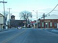
Downtown Wrightstown along WIS 96. You can see St. Paul Catholic Church in the background.
-
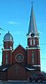
The old St. John Lutheran Church building, now Turner Street Music Hall.
-
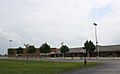
Wrightstown High School.
-
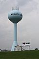
The water tower in Wrightstown.
-
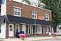
The post office in Wrightstown.
-
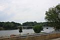
The WIS 96 bridge crossing the Fox River.
-
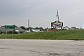
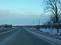
Another welcome sign for Wrightstown.


See also
 In Spanish: Wrightstown (Wisconsin) para niños
