Kaukauna (town), Wisconsin facts for kids
Quick facts for kids
Kaukauna, Wisconsin
|
|
|---|---|

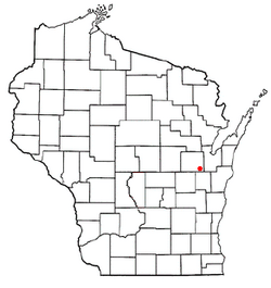
Location of the town of Kaukauna, Wisconsin
|
|
| Country | |
| State | |
| County | Outagamie |
| Organized | April 7, 1842 |
| Area | |
| • Total | 18.1 sq mi (46.8 km2) |
| • Land | 17.8 sq mi (46.0 km2) |
| • Water | 0.3 sq mi (0.8 km2) |
| Elevation | 679 ft (207 m) |
| Population
(2010)
|
|
| • Total | 1,238 |
| • Density | 64.3/sq mi (24.8/km2) |
| Time zone | UTC-6 (Central (CST)) |
| • Summer (DST) | UTC-5 (CDT) |
| Area code(s) | 920 |
| FIPS code | 55-38825 |
| GNIS feature ID | 1583464 |
Kaukauna is a small town in Outagamie County, Wisconsin, United States. In 2010, about 1,238 people lived there. A part of the small community called Sniderville is also located within the town.
Contents
History of Kaukauna
The Town of Kaukauna was officially started on April 7, 1842. Back then, it was known as Kaukaulan. It was originally part of Brown County. Outagamie County was not formed until 1851.
When it was first created, the town of Kaukauna included all of what would later become Outagamie County. It also included parts of Brown County, near Wrightstown.
As more people moved into the area, some parts of Kaukauna became new towns. In 1849, the towns of Grand Chute and Lansing were separated from Kaukauna. After this, Kaukauna included its current area, all of the Town of Vandenbroek, and parts of the Town of Buchanan.
In 1858, the part that became the Town of Buchanan was separated. Later, in 1885, the nearby City of Kaukauna became its own city and was no longer part of the town. The last big change happened in 1902 when the Town of Vandenbroek became a separate township. This gave the Town of Kaukauna its size that is similar to today. On February 28, 2002, some more parts of the town were added to Wrightstown, Wisconsin. This process is called annexation.
Geography of Kaukauna
In 2021, the town covered a total area of about 18.1 square miles (46.8 square kilometers). Most of this area, about 17.8 square miles (46.0 square kilometers), is land. The rest, about 0.3 square miles (0.8 square kilometers), is water.
Population and People
According to the 2021 census, there were about 17,170 people living in the town. There were also about 10,652 households. The town had a population density of about 213.8 people per square mile.
Many families lived in Kaukauna. About 44.1% of households had children under 18 living with them. Most households, about 75.9%, were married couples living together.
The people in the town were of different ages. About 31.1% of the population was under 18 years old. About 9.5% of the people were 65 years old or older. The average age of people in the town was 36 years.
Notable People from Kaukauna
- Anton M. Miller: He was a farmer and a politician from Wisconsin who lived in the town. A politician is someone who works in government.
- William M. Rohan: He was also a farmer and a politician from Wisconsin. He served as the chairman and treasurer of the town. A chairman is like a leader of a group or committee.
See also
 In Spanish: Kaukauna (condado de Outagamie, Wisconsin) para niños
 | Sharif Bey |
 | Hale Woodruff |
 | Richmond Barthé |
 | Purvis Young |

