Wyoming, Delaware facts for kids
Quick facts for kids
Wyoming, Delaware
|
|
|---|---|

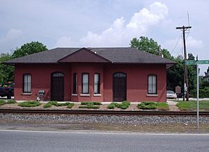
Railroad depot in Wyoming
|
|
| Etymology: Wyoming Valley in Pennsylvania | |

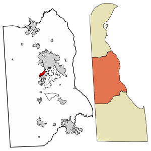
Location of Wyoming in Kent County, Delaware.
|
|
| Country | |
| State | |
| County | Kent |
| Government | |
| • Type | Mayor-council |
| Area | |
| • Total | 1.06 sq mi (2.75 km2) |
| • Land | 1.05 sq mi (2.71 km2) |
| • Water | 0.02 sq mi (0.04 km2) |
| Elevation | 39 ft (12 m) |
| Population
(2020)
|
|
| • Total | 1,680 |
| • Density | 1,604.58/sq mi (619.74/km2) |
| Time zone | UTC−5 (Eastern (EST)) |
| • Summer (DST) | UTC−4 (EDT) |
| ZIP code |
19934
|
| Area code(s) | 302 |
| FIPS code | 10-81350 |
| GNIS feature ID | 217870 |
Wyoming is a small town in Kent County, Delaware, United States. It got its name from the Wyoming Valley in Pennsylvania. Wyoming is part of the larger Dover metropolitan area. In 2020, about 1,680 people lived there.
Contents
History of Wyoming
The town of Wyoming began because of a railroad. The nearby town of Camden did not want the Delaware Railroad to build tracks through their town. So, the railroad built a station about a mile west of Camden's center. This new area was first called West Camden.
In 1865, a minister named John J. Pierce moved to West Camden. He came from the Wyoming Valley in Pennsylvania. He started planning new homes in the area. Many people from the Wyoming Valley also moved there. Because of these new residents, people decided to change the town's name. They wanted a new identity, so they chose "Wyoming" to honor the new families.
A post office opened in Wyoming in 1866. The community officially became a town in 1869. Some important places in Wyoming are listed on the National Register of Historic Places. These include the Lewis Family Tenant Agricultural Complex, the Wyoming Historic District, and the Wyoming Railroad Station.
In 1975, there was a vote to combine Wyoming with the town of Camden. Camden residents voted yes, but Wyoming residents voted no. So, the towns remained separate. Wyoming's town council had also said no to a merger idea in 1967.
Geography and Climate
Wyoming is located at 39°07′05″N 75°33′32″W / 39.11806°N 75.55889°W. The town covers about 0.7 square miles (1.8 square kilometers). Most of this area is land, with a small part being water.
Wyoming's Climate
Wyoming has a climate with hot, humid summers. Winters are usually mild to cool. This type of weather is called a humid subtropical climate.
| Climate data for Wyoming, Delaware | |||||||||||||
|---|---|---|---|---|---|---|---|---|---|---|---|---|---|
| Month | Jan | Feb | Mar | Apr | May | Jun | Jul | Aug | Sep | Oct | Nov | Dec | Year |
| Record high °F (°C) | 77 (25) |
80 (27) |
87 (31) |
97 (36) |
98 (37) |
100 (38) |
104 (40) |
102 (39) |
98 (37) |
95 (35) |
85 (29) |
75 (24) |
104 (40) |
| Mean daily maximum °F (°C) | 43 (6) |
47 (8) |
55 (13) |
66 (19) |
75 (24) |
83 (28) |
87 (31) |
85 (29) |
79 (26) |
69 (21) |
59 (15) |
47 (8) |
66 (19) |
| Mean daily minimum °F (°C) | 27 (−3) |
29 (−2) |
36 (2) |
44 (7) |
54 (12) |
63 (17) |
69 (21) |
67 (19) |
60 (16) |
49 (9) |
40 (4) |
31 (−1) |
47 (8) |
| Record low °F (°C) | −7 (−22) |
−11 (−24) |
7 (−14) |
14 (−10) |
28 (−2) |
41 (5) |
45 (7) |
35 (2) |
30 (−1) |
25 (−4) |
11 (−12) |
−3 (−19) |
−11 (−24) |
| Average precipitation inches (mm) | 3.41 (87) |
3.18 (81) |
4.31 (109) |
3.88 (99) |
4.25 (108) |
4.00 (102) |
4.09 (104) |
4.36 (111) |
4.13 (105) |
3.42 (87) |
3.48 (88) |
3.65 (93) |
46.16 (1,174) |
| Source: The Weather Channel | |||||||||||||
People of Wyoming
| Historical population | |||
|---|---|---|---|
| Census | Pop. | %± | |
| 1870 | 280 | — | |
| 1880 | 353 | 26.1% | |
| 1890 | 497 | 40.8% | |
| 1900 | 450 | −9.5% | |
| 1910 | 517 | 14.9% | |
| 1920 | 661 | 27.9% | |
| 1930 | 684 | 3.5% | |
| 1940 | 870 | 27.2% | |
| 1950 | 911 | 4.7% | |
| 1960 | 1,172 | 28.6% | |
| 1970 | 1,062 | −9.4% | |
| 1980 | 960 | −9.6% | |
| 1990 | 977 | 1.8% | |
| 2000 | 1,141 | 16.8% | |
| 2010 | 1,313 | 15.1% | |
| 2020 | 1,680 | 28.0% | |
| U.S. Decennial Census | |||
In 2000, there were 1,141 people living in Wyoming. The town had 448 households. About 32.8% of these households had children under 18. The population included people of different backgrounds. About 79.5% were White, 13.3% were African American, and 3.9% were Asian. About 2.5% of the population was Hispanic or Latino.
The average age in Wyoming was 37 years old. About 25% of the people were under 18.
Education in Wyoming
Wyoming is part of the Caesar Rodney School District. Most students in Wyoming go to W. B. Simpson Elementary School. Some students attend W. Reilly Brown Elementary School in Dover. After elementary school, students go to Fred Fifer III Middle School in Camden. All students in the district attend Caesar Rodney High School in Camden.
Fun Things to Do
Wyoming has some fun local events:
- The Wyoming Peach Festival happens every August. You can enjoy pageants and homemade peach ice cream. You can also tour Fifer Orchards, which grows the most peaches and apples in Delaware.
- The Caesar Rodney Homecoming Parade takes place every November. It supports the Caesar Rodney Riders football team for their homecoming game.
Getting Around and Services
Transportation
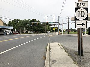
- Roads: Delaware Route 10 runs along the edge of Wyoming. It goes west towards Maryland and east through Camden. Delaware Route 15 goes north through Wyoming towards Dover and south towards Woodside.
- Buses: DART First State offers bus service. Route 104 connects Wyoming to the Walmart in Camden and the Dover Transit Center in Dover.
- Trains: The Delmarva Central Railroad's line runs through Wyoming.
- Airport: Jenkins Airport, a small airport for general aviation, is just west of Wyoming.
Utilities and Services
- Electricity: Delmarva Power provides electricity to Wyoming homes and businesses.
- Natural Gas: Chesapeake Utilities supplies natural gas to the town.
- Water and Sewer: The Camden-Wyoming Sewer & Water Authority handles water and sewer services for Wyoming and Camden.
- Trash: Republic Services collects trash and recycling in Wyoming.
See also
 In Spanish: Wyoming (Delaware) para niños
 | John T. Biggers |
 | Thomas Blackshear |
 | Mark Bradford |
 | Beverly Buchanan |


