
Yahoola Creek facts for kids
Yahoola Creek is a cool stream located in Georgia. It flows into a bigger river called the Chestatee River. The creek is about 17.32 miles (27.87 kilometers) long. The name Yahoola comes from the Cherokee language.
Where Yahoola Creek Flows

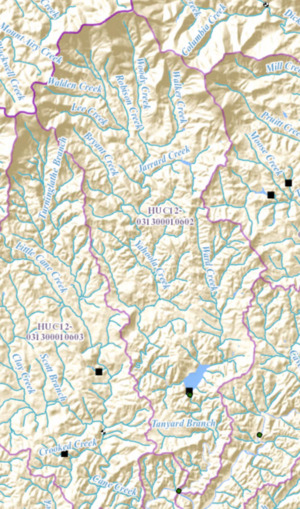
Yahoola Creek starts where two smaller creeks, Walden Creek and Walnut Cove Creek, meet. This spot is in north-central Lumpkin County. It's about two miles southeast of Suches. This area is also part of the Chattahoochee-Oconee National Forest.
The creek flows south for a short distance. Then, Lee Creek and Robison Creek join it. It continues south and Woody Creek also flows into it. Woody Creek runs next to Yahoola Creek before they meet.
A little further, Jarrard Creek joins the flow. Yahoola Creek then picks up two more small streams. It makes a sharp turn to the west to meet Bryant Creek. After that, it turns back south.
Yahoola Creek flows south for about 4.5 miles. It then leaves the national forest. After another 3.2 miles, it meets Ward Creek. This happens just after crossing U.S. Route 19 and State Route 60. Here, the two creeks form Lake Zwerner, which is just north of Dahlonega.
The creek leaves Lake Zwerner and flows south. After 1.6 miles, Tanyard Branch joins it. Finally, about three miles further south, Yahoola Creek flows into the Chestatee River. This meeting point is also near U.S. Route 19 and State Route 60, south of Dahlonega.
Understanding the Creek's Area
The area that Yahoola Creek and its connected waters drain is called a watershed. The United States Geological Survey has given this specific watershed a special code: HUC 031300010602. It's known as the Yahoola Creek sub-watershed.
This watershed covers about 34 square miles north of Dahlonega. Smaller creeks like Bryant Creek to the west and Woody Creek to the northeast help drain their own areas. They pick up several unnamed streams before joining Yahoola Creek.
