
Yarmouth Port, Massachusetts facts for kids
Quick facts for kids
Yarmouth Port, Massachusetts
|
|
|---|---|

Boardwalk at Bass Hole
|
|

Location in Barnstable County and the state of Massachusetts
|
|
| Country | United States |
| State | Massachusetts |
| County | Barnstable |
| Town | Yarmouth |
| Area | |
| • Total | 6.48 sq mi (16.78 km2) |
| • Land | 6.02 sq mi (15.59 km2) |
| • Water | 0.46 sq mi (1.19 km2) |
| Elevation | 52 ft (16 m) |
| Population
(2020)
|
|
| • Total | 5,403 |
| • Density | 897.66/sq mi (346.59/km2) |
| Time zone | UTC-5 (Eastern (EST)) |
| • Summer (DST) | UTC-4 (EDT) |
| ZIP code |
02675
|
| Area code(s) | 508/774 |
| FIPS code | 25-82595 |
| GNIS feature ID | 0615805 |
Yarmouth Port is a community located in the town of Yarmouth in Barnstable County, Massachusetts, United States. It is known as a census-designated place (CDP). This means it is an area identified by the U.S. Census Bureau for statistical purposes.
In 2020, about 5,403 people lived in Yarmouth Port. It was once home to the first Christmas Tree Shops store, which closed in 2007. Today, Yarmouth Port is also where the main office for the IFAW is located. IFAW is a global group that works to protect animals.
Contents
Where is Yarmouth Port?
Yarmouth Port is in the northern part of the town of Yarmouth. Its exact location is 41°42′17″N 70°13′15″W / 41.70472°N 70.22083°W. This means it is at 41.704633 degrees north and 70.220923 degrees west.
The community is surrounded by water and other towns. To the north, it borders Cape Cod Bay. To the east, you'll find the town of Dennis. To the west, it borders the town of Barnstable.
Land and Water Area
Yarmouth Port covers a total area of about 6.47 square miles (16.76 square kilometers). Most of this area is land, about 6.04 square miles (15.65 square kilometers).
The rest is water, which makes up about 0.43 square miles (1.11 square kilometers). This means about 6.86% of Yarmouth Port is covered by water.
Who Lives in Yarmouth Port?
| Historical population | |||
|---|---|---|---|
| Census | Pop. | %± | |
| 2020 | 5,403 | — | |
| U.S. Decennial Census | |||
In 2000, there were 5,395 people living in Yarmouth Port. These people lived in 2,546 homes, and 1,642 of these were family homes. The population density was about 892.7 people per square mile (344.9 per square kilometer).
Most of the people living in Yarmouth Port were White (98.46%). A small number were African American, Native American, or Asian. About 0.70% of the people were Hispanic or Latino.
Age and Income
The community has a mix of age groups. In 2000, about 15.8% of the people were under 18 years old. A large portion, 34.7%, were 65 years or older. The average age of people in Yarmouth Port was 53 years.
The average income for a household was about $47,576 per year. For families, the average income was higher, around $57,841 per year. A small number of families and people lived below the poverty line.
Famous People from Yarmouth Port

- Edward Gorey (1925–2000): He was a well-known American artist and writer. He was famous for his unique and often spooky drawings and stories. His home on Cape Cod, known as the Elephant House, is now a museum.
Images for kids
-
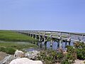
Boardwalk at Bass Hole
-
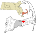
Location in Barnstable County and the state of Massachusetts
See also
 In Spanish: Yarmouth Port (Massachusetts) para niños
