Yethonat, Washington facts for kids
Quick facts for kids
Yethonat, Washington
|
|
|---|---|
| Country | United States |
| State | Washington |
| County | Yakima |
| Elevation | 810 ft (247 m) |
| Time zone | UTC-8 (Pacific (PST)) |
| • Summer (DST) | UTC-7 (PDT) |
| ZIP code |
98951
|
| Area code(s) | 509 |
| GNIS feature ID | 1511444 |
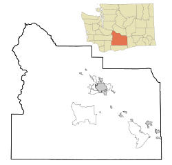
Yethonat is a small, rural place in Yakima County, Washington, United States. It is called an "unincorporated community." This means it does not have its own city government. Instead, it is part of the larger county area.
Yethonat is known for its farms and quiet country life. It is located between the towns of Wapato and Toppenish. You can find it just off U.S. Route 97.
About Yethonat
Yethonat is a peaceful place focused on agriculture. Farming is a very important part of life here. The community grew up around a railway line. This railway helped connect Yethonat to other places.
Where is Yethonat?
Yethonat is in the central part of Washington state. It is located in Yakima County, which is known for its rich farmlands. The community sits at an elevation of about 247 meters (810 feet) above sea level. This area is part of the Pacific Time Zone.
A Look at Yethonat's History
The development of Yethonat is closely tied to the railway. The community first started growing along the Toppenish, Simcoe and Western Railway Company line. Railways were very important in the past. They helped transport goods and people across the country. For Yethonat, the railway likely helped farmers get their crops to market.
Life in Yethonat
Life in Yethonat is mostly rural. This means it's a quiet place with lots of open land. The main activity is agriculture. People in Yethonat work with crops and farms. It is a close-knit community where neighbors often know each other well.


