Yungay, Chile facts for kids
Quick facts for kids
Yungay
|
|||
|---|---|---|---|
|
|||

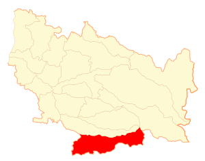
Map of the Yungay commune in the Ñuble Region
|
|||
| Country | Chile | ||
| Region | Ñuble | ||
| Province | Diguillín | ||
| Villa de Yungay | 20 January 1842 | ||
| Government | |||
| • Type | Municipality | ||
| Area | |||
| • Total | 823.5 km2 (318.0 sq mi) | ||
| Elevation | 268 m (879 ft) | ||
| Population
(2012 Census)
|
|||
| • Total | 16,949 | ||
| • Density | 20.5817/km2 (53.306/sq mi) | ||
| • Urban | 11,469 | ||
| • Rural | 5,345 | ||
| Sex | |||
| • Men | 8565 | ||
| • Women | 8249 | ||
| Time zone | UTC−4 (CLT) | ||
| • Summer (DST) | UTC−3 (CLST) | ||
| Area code(s) | 56 + 42 | ||
| Climate | Csb | ||
| Website | Municipality of Yungay | ||
Yungay is a town and commune in Chile. It is located in the Diguillín Province of the Ñuble Region. The commune covers an area of about 823.5 square kilometers.
Contents
Who Lives in Yungay?
In 2002, a study counted the people living in Yungay. There were 16,814 inhabitants in total. Most people, about 11,469 (68.2%), lived in urban areas, which are like cities or big towns. The rest, 5,345 people (31.8%), lived in rural areas, which are more like the countryside.
At that time, there were 8,565 men and 8,249 women living in the commune. Between 1992 and 2002, Yungay's population grew by 10%. This means more people moved there or were born there.
Main Towns in Yungay
The Yungay commune includes several towns. Here are some of the main ones and how many people lived in them in 2002:
- Yungay: This is the main town and the center of the commune, with 9,288 people.
- Campanario: This town had 2,181 people.
- Cholguán: About 718 people lived here.
- Ranchillo: This town had 319 people.
- El Roble: About 152 people lived in El Roble.
- Los Castaños: This town had 142 people.
- Chillancito: About 62 people lived here.
How Yungay is Governed
Yungay is a commune, which is a local government area in Chile. It is managed by a municipal council. The council is led by an alcalde, who is like a mayor. The people of Yungay vote for their alcalde every four years.
From 2016 to 2020, the alcalde was Rafael Cifuentes Rodríguez. The council members during that time were:
- Juana Sandoval Rojas
- Rodrigo Stuardo Hernández
- Ángelica Cabezas González
- Juan Quezada Garrido
- Ricardo Ramos Martínez
- Patricia Moncada Morales
Yungay is also part of a larger area for national elections. It helps choose representatives for the Chamber of Deputies and the Senate. These groups make laws for the whole country.
Yungay's Landscape and Land Use
The Yungay commune is quite large, covering about 823 square kilometers. However, only a small part of it, about 3.87 square kilometers, is developed into towns and cities. The main urban areas are Yungay and Campanario. In 2017, the total number of people living in the commune was 17,787.
Yungay is located on the eastern side of its region. This means it includes parts of the Andes mountains. The land here can be anywhere from 150 to 2000 meters above sea level. Many rivers flow from the Andes through the region.
Most of the land in Yungay is used for farming. Farmers grow things like California Pine trees, wheat, oats, and lentils. Some areas are also used for livestock grazing, where animals like cows and sheep eat grass.
Yungay's Library
The public library in Yungay is named after a priest called Oreste Montero. He was very important for education in Yungay. He helped many students and left a good memory with people because of his kind nature.
Today, the library has grown a lot. It offers new services, like a computer lab. This lab is very helpful for students from local high schools who might not have computers or internet at home.
See also
 In Spanish: Yungay (comuna) para niños
 | Shirley Ann Jackson |
 | Garett Morgan |
 | J. Ernest Wilkins Jr. |
 | Elijah McCoy |


