
Ñuble Region facts for kids
Quick facts for kids Ñuble Region (Región de Ñuble) |
|||
| Region of Chile | |||
 Catedral of Chillán
|
|||
|
|||
| Country | |||
|---|---|---|---|
| Provinces | Diguillín, Itata, Punilla | ||
| Capital | Chillán | ||
| - coordinates | 36°36′S 72°07′W / 36.600°S 72.117°W | ||
| Lowest point | Pacific Ocean | ||
| - elevation | 0 m (0 ft) | ||
| Area | 13,178.5 km² (5,088 sq mi) | ||
| Population | 480,609 (2017) | ||
| Density | 36 /km² (93 /sq mi) | ||
| Intendant | Martín Arrau | ||


The Ñuble Region (which is called Región de Ñuble in Spanish) is one of Chile's 16 main areas. Its capital city is Chillán.
This region was created on September 6, 2018. Before that, it was part of the Ñuble Province. When it became a region, it was also divided into 3 new provinces. The region is named after the Ñuble river.
Contents
Where is Ñuble Located?
The Ñuble region covers an area of about 13,178.5 square kilometers (5,088 square miles).
It shares borders with the Maule region to the north. To the east, it borders Argentina. The Bío Bío region is to its south, and the Pacific Ocean is to its west.
 |
Maule region | |
||
| Pacific Ocean | Argentina | |||
| Bío Bío region |
The main rivers in the region are:
The highest mountains in the region are part of the Andes mountain range. These tall mountains, called the Nevados de Chillán, are found in the eastern part of the region.
What is the Climate Like?
The climate in Chillán is a Mediterranean climate. This type of climate is known as Csb in the Köppen climate classification system.
On average, Chillán gets about 696 millimeters (27.4 inches) of rain each year. June is usually the wettest month, with about 185.4 millimeters (7.3 inches) of rain. February is the driest month, receiving only about 2.5 millimeters (0.1 inches) of rain.
The average temperature in Chillán throughout the year is 14.4°C (57.9°F). The warmest month is typically January, with an average temperature of 21.1°C (70.0°F). The coolest month is usually July, with an average temperature of 8.3°C (46.9°F).
How Many People Live in Ñuble?
According to the last national census in As of 2002[update], there were 438,103 people living in the Ñuble region. This means there were about 33.2 people per square kilometer (86 people per square mile).
About 285,108 people lived in cities and towns. This was about 65% of the total population.
The largest city in the region is its capital, Chillán, which had 146,701 residents in 2002. Other important cities include San Carlos (with 29,359 people) and Chillán Viejo (with 18,827 people).
Provinces and Communes
The Ñuble Region is divided into 3 provinces. These provinces are then further divided into 21 smaller areas called communes.
| Communes of the Ñuble Region | |||||||||||||||||||||||||||||||
|---|---|---|---|---|---|---|---|---|---|---|---|---|---|---|---|---|---|---|---|---|---|---|---|---|---|---|---|---|---|---|---|
|
 |
||||||||||||||||||||||||||||||
See Also
Images for kids
-
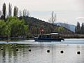
Avendaño Lake located in Quillón.
-
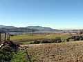
View of Itata River


Learn More
 In Spanish: Región de Ñuble para niños
