San Carlos, Chile facts for kids
Quick facts for kids
San Carlos
|
|||||
|---|---|---|---|---|---|

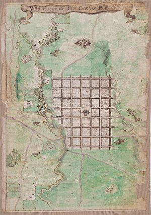
Map of the foundation of San Carlos in 1805
|
|||||
|
|||||
| Country | Chile | ||||
| Region | Ñuble | ||||
| Province | Punilla | ||||
| Founded | July 3, 1800 | ||||
| Founded as | San Carlos de Itihue | ||||
| Government | |||||
| • Type | Municipality | ||||
| Area | |||||
| • Total | 874.0 km2 (337.5 sq mi) | ||||
| Elevation | 161 m (528 ft) | ||||
| Population
(2012 Census)
|
|||||
| • Total | 51,035 | ||||
| • Density | 58.392/km2 (151.236/sq mi) | ||||
| Demonym(s) | Sancarlino | ||||
| Sex | |||||
| Time zone | UTC−4 (CLT) | ||||
| • Summer (DST) | UTC−3 (CLST) | ||||
| Postal code |
3840000
|
||||
| Area code(s) | 56 + 42 | ||||
| Website | Official website: http://www.sancarlos.cl/ | ||||
San Carlos is a city and a commune (which is like a local area or district) in the Punilla Province of the Ñuble Region in Chile.
Contents
Geography and Farming
San Carlos is a busy market town in the middle of Chile's farming area. It is about 365 kilometers (227 miles) south of Santiago. It's also 133 kilometers (83 miles) northeast of Concepción, which is the main city of the region. Chillán, the capital of the province, is 32 kilometers (20 miles) north.
The city is on a flat plain between Chillán and the Perquilauquén river. The commune covers an area of 874 square kilometers (337 square miles). Most of its land is in the fertile central plain, also known as the "Chilean Central Valley." The countryside around San Carlos is famous for growing many different crops. These include apples, grapes, berries, and recently, kiwi.
San Carlos shares its borders with several other communes. To the west is Ninhue, and to the north are Ñiquén and Cauquenes. To the east, it borders San Fabián, and to the south, it borders San Nicolás, Chillán, and Coihueco.
Climate and Weather
San Carlos has a mild Mediterranean climate. This means the summers (from November to March) are hot and mostly dry. Temperatures can reach up to 34°C (93°F) in December, January, and February.
| Season | Fall | Winter | Spring | Summer | |||||||||
|---|---|---|---|---|---|---|---|---|---|---|---|---|---|
| Average rainfall, in mm (%) | 349 (26%) | 708 (53%) | 220 (16%) | 69 (5%) | |||||||||
| Source: [1] | |||||||||||||
Population and People
San Carlos is the second largest city in the Ñuble Region by population. In 2002, a census showed that the city had 29,359 people. The entire commune of San Carlos had 50,088 people. About 62% of the people live in the city (urban areas), and 38% live in the countryside (rural areas).
The population of San Carlos has been growing. Between 1992 and 2002, the population increased by 4.1%. In 2006, it was estimated that the commune had 51,119 people.
The commune also includes many smaller villages and rural places. The second largest place after San Carlos is Cachapoal. In 2002, it had 1,164 residents.
History of San Carlos
The city of San Carlos was founded by a Spanish person named don José Joaquín del Pino de Rozas y Negrete. This happened on July 3, 1800.
An important event in the Chilean War of Independence took place here. On May 15, 1813, the Battle of San Carlos happened. The patriot army, led by General José Miguel Carrera, won against the royalist army. This victory helped the patriot movement grow throughout the region.
Culture and Famous People
San Carlos is known as the birthplace of many artists and famous people. These include painters, writers, and singers. The painter Hernán Gazmuri was born here. The famous music group Los Angeles Negros (The Black Angels) also started in San Carlos.
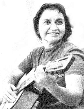
Violeta Parra is another very famous artist from San Carlos. She was a well-known folklorist, writer, researcher, and singer. Her birth house is believed to be at El Roble # 535-531. This house was declared a National Monument in 1992.
There is a project to create a "Casa Museo de Violeta Parra" (House Museum of Violeta Parra) in San Carlos. This museum would celebrate her life and work.
One of the city's attractions is the Medialuna of San Carlos. This is a sports arena where Chilean rodeo is practiced. It can hold 8,000 people, making it the second largest rodeo arena after the Medialuna of Rancagua. Chilean rodeo is a very popular sport in this area.
Education in San Carlos
San Carlos has about 50 elementary schools, with 10 of them in the city area. It also has 6 high schools, and 5 of these are in the city.
Religion in San Carlos
According to the 2002 census, most people in San Carlos commune (aged 15 or older) are Catholics, making up about 68.51% of the population. About 22.01% are Evangelical protestants. Smaller groups include Jehovah's Witnesses and Latter-day Saints. About 5.03% of the people said they were atheist or agnostic, and 3.19% followed other religions.
Notable Residents
General Sofanor Parra was born in San Carlos in 1850. He was a well-known Chilean officer in the army's cavalry. He was important during the War of the Pacific.
San Carlos is also the birthplace of Violeta Parra, who is one of the most recognized names in Chilean and Latin American folk music. She is celebrated as a great folk artist, writer, painter, researcher, and singer. The house where she was born in San Carlos was made a National Monument in 1992. Other artists from San Carlos include painters like Hernán Gazmuri and the popular 1970s band, Los Ángeles Negros.
City Leadership
As a commune, San Carlos is managed by a municipal council. This council is led by an alcalde, who is like a mayor. The alcalde is chosen by direct vote every four years. The alcalde from 2008-2012 was Hugo Naim Gebrie Asfura.
Twin City
San Carlos has a "twin city" relationship with Baena, a city in Spain. Baena is located in Andalucia, in southern Spain. The founder of San Carlos, José Joaquín del Pino de Rozas y Negrete, was born in Baena.
Images for kids
See also
 In Spanish: San Carlos (comuna) para niños
 | Laphonza Butler |
 | Daisy Bates |
 | Elizabeth Piper Ensley |


