Yunnan–Guizhou Plateau facts for kids
Quick facts for kids Yunnan–Guizhou Plateau |
|
|---|---|
| Yungui Plateau | |

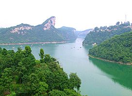
Karst geography on the Yungui Plateau near Guiyang
|
|

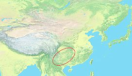
Topographic map of East Asia with Yungui Plateau highlighted
|
|
| Floor elevation | 500 m (1,600 ft) to 2,500 m (8,200 ft) |
| Geography | |
| Country | China |
| Provinces | Yunnan, Guizhou |
| Region | Southwest China |
| Yunnan–Guizhou Plateau | |||||||||
|---|---|---|---|---|---|---|---|---|---|
| Traditional Chinese | 雲貴高原 | ||||||||
| Simplified Chinese | 云贵高原 | ||||||||
| Postal | Yunnan–Kweichow Plateau | ||||||||
|
|||||||||
| Yungui Plateau | |||||||||
|---|---|---|---|---|---|---|---|---|---|
| Traditional Chinese | 雲貴高原 | ||||||||
| Simplified Chinese | 云贵高原 | ||||||||
| Postal | Yunkwei Plateau | ||||||||
|
|||||||||
The Yunnan–Guizhou Plateau, also called the Yungui Plateau (simplified Chinese: 云贵高原; traditional Chinese: 雲貴高原; pinyin: Yúnguì Gāoyuán), is a large highland area in southwest China. It mainly covers the Chinese provinces of Yunnan and Guizhou. In the southwest, it's a flatter plateau. But in the northeast, it has many rolling hills, deep gorges, and unique karst topography. Karst is a landscape made of soluble rock like limestone, creating caves and sinkholes.
Contents
Exploring the Yungui Plateau
Where is the Yungui Plateau Located?
The Yungui Plateau stretches from the Red River Fault in Yunnan to the Wuling Mountains in Hunan. This main plateau area includes most of eastern Yunnan and nearly all of Guizhou. However, people often use the name "Yunnan–Guizhou Plateau" for a much larger region. This wider area includes other parts of Yunnan and nearby highlands.
Under this broader idea, the plateau region also includes:
- Gulin County
- Southern parts of Sichuan
- Eastern Chongqing
- Southwestern Hubei
- Western Hunan
- Northwestern Guangxi
People and Cities of the Plateau
The Yungui Plateau is located in Southwest China. It acts as a natural barrier between the Sichuan Basin and South China. For a long time, this area was considered a remote part of China. Many different ethnic groups have lived here for centuries. They traditionally farmed on the hillsides and in the valleys.
Today, many people on the Yungui Plateau still live in traditional ways in rural villages. Major cities in this region include Kunming, Guiyang, and Zunyi. Building roads and railways here is very challenging because of the tough landscape. Engineers have created amazing structures, like the Beipanjiang Bridge. This bridge is one of the world's highest bridges and crosses the Yunnan-Guizhou border.
What is the Landscape Like?
The Yungui Plateau is a large, mountainous area. It has very rugged terrain with steep karst peaks and deep gorges. To the northwest, it is bordered by the huge Hengduan Mountains. Lowland areas are found to its north, east, and southeast.
Other important mountain ranges cross or surround parts of the Yungui Plateau:
- The Wumeng Mountains and Wulian Feng run through north-central Yungui. They follow the Jinsha River (which is the upper part of the Yangtze River).
- To the north, the Dalou Mountains mark the edge of the Yungui Plateau with the Sichuan Basin.
- The Wuling Mountains in the northeast connect the plateau to the Yangtze Plain.
- In the south, the Miao Range gradually lowers into the karst hills of South China.
- Across the Red River to the southwest, the Ailao Mountains form a clear boundary.
Many of Asia's great rivers start in the high mountains of Eastern Tibet. These rivers flow south towards the Yunnan–Guizhou Plateau. The rivers then split around the plateau. The Salween and Mekong continue south. The Yangtze River turns northeast. Most of the western Yungui Plateau is drained by the Nanpan and Beipan Rivers. These rivers are the starting points for the Pearl River. The eastern Yungui Plateau is mostly drained by the Wu River, which flows into the Yangtze.
Several large lakes are found in the Yunnan parts of the Yungui Plateau. These include Dian Chi and Fuxian Lake. Erhai Lake is located on the western edge of the plateau. It sits at the southern base of the Hengduan Mountains.
Climate and Nature
The climate across the Yungui Plateau changes gradually. It is drier in the southwest and gets rainier towards the northeast. In east-central Yunnan, some parts of the Yungui Plateau have a semi-arid climate, meaning they are quite dry. In most of Guizhou, the climate is humid subtropical, which means it's warm and wet.
The Yungui Plateau is covered by different types of forests. The Yunnan parts mostly have Yunnan Plateau subtropical evergreen forests. These forests have trees that stay green all year. The Guizhou parts are covered by Guizhou Plateau broadleaf and mixed forests, which have a mix of different tree types.
See also
 In Spanish: Meseta Yunnan-Guizhou para niños
 | Sharif Bey |
 | Hale Woodruff |
 | Richmond Barthé |
 | Purvis Young |


