
Zaña River facts for kids
Quick facts for kids Zaña River |
|
|---|---|

The Zaña River near its mouth.
|
|

Location of mouth
|
|
| Peru | Lambayeque, Cajamarca regions |
| Physical characteristics | |
| Main source | 3,750 metres (12,300 ft) 6°59′56″S 76°56′24″W / 6.999°S 76.940°W |
| River mouth | 0 m (0 ft) 6°55′41″S 78°53′35″W / 6.928°S 78.893°W |
| Length | 119 kilometres (74 mi) |
| Basin features | |
| Basin size | 2,158 square kilometres (833 sq mi) |
The Zaña River (also called Saña River) is a small river in northern Peru. It is about 119 kilometres (74 mi) long. The river starts high up in the Andes mountains in the Cajamarca Region. It then flows all the way to the Pacific Ocean in the Lambayeque Region.
Near the ocean, the Zaña River flows through a dry coastal desert. Because of this, farmers use its water to grow crops. The river often dries up near its mouth. But higher up in the Andes, there is a lot more rain. This can cause big floods downstream. One very large flood in 1720 destroyed the important city of Zaña. The city was rebuilt, but it never became as big or important as it was before. Other towns in the lower valley include Mocupe, Cayalti, Nueva Arica, and Oyotun.
The Zaña River's highest source is at an elevation of about 3,750 metres (12,300 ft).
Unique Forests and Wildlife
The Zaña River basin has a special feature: semi-tropical forests. These forests grow at elevations above 2,000 metres (6,600 ft) in the upper parts of the river valley. They are unusual because this part of the Andes is not very high. It sits between the dry coast of western Peru and the wet Amazon Basin to the east.
Because of this unique location, you can find plants and animals here that usually live in the Amazon rainforest. The Peruvian government wanted to protect these special forests. In 2010, they created the "Reserved Zone of Udima." This area covers 30,503 hectares (75,370 acres) and protects the Zaña River's headwaters. In 2011, a smaller part of this zone became the Bosques Nublados de Udima Wildlife Refuge. This refuge, also known as the Cloud Forests of Udima Wildlife Refuge, is 12,183 hectares (30,100 acres) in size.
Ancient Discoveries
Many ancient ruins from before Christopher Columbus arrived are found along the Zaña River. Near the Nanchoc river, which flows into the Zaña, archaeologists have made exciting discoveries.
The archaeologist Tom Dillehay found what might be the oldest irrigation canals in the Americas. These canals were used to bring water to crops. Scientists used radiocarbon dating to find out how old they are. They are at least 3400 BCE, and possibly even as old as 4700 BCE! The people of Nanchoc built these canals to water crops like peanuts, squash, manioc, and chenopods. Chenopods are related to Quinoa.
In 2019, another Peruvian archaeologist, Walter Alva, found the ruins of a huge stone temple. It was discovered in the Zaña Valley near Oyotun. This temple likely belonged to the Chavin culture, which existed from 900 to 200 BCE. The temple is 56 metres (184 ft) long and 40 metres (130 ft) wide. It was built using very large stones that were moved from far away. Alva believes this temple is part of an even bigger ancient complex.
Images for kids
-
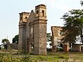
The ruins of Zaña, destroyed by a flood in 1720.

See also
 In Spanish: Río Zaña para niños
