Zahara de los Atunes facts for kids
Quick facts for kids
Zahara de los Atunes
|
|||
|---|---|---|---|
|
Village
|
|||

Zahara de los Atunes
|
|||
|
|||
| Country | |||
| Autonomous community | Andalusia | ||
| Province | Province of Cádiz | ||
| Comarca | La Janda | ||
| municipality | Barbate | ||
| Elevation | 12 m (39 ft) | ||
| Population
(2012)
|
|||
| • Total | 1,200 | ||
| Patrons:saint Joseph, Our Lady of Mount Carmel | |||
| Demonym(s) | Zahareños/ Zahareñas | ||
| Time zone | UTC+1 (CET) | ||
| • Summer (DST) | UTC+2 (CEST) | ||
| Postal code |
11393
|
||
| Dialing code | (+34) 956 43/45 | ||
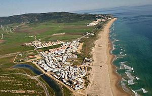
Zahara de los Atunes is a lovely village in Spain. It is located on the Costa de la Luz (Coast of Light) in the Province of Cádiz. This area is part of the Andalusia region.
The village is famous for its beautiful beaches. It also has an outdoor cinema, which is a fun place to watch movies. A special place in town is the Iglesia Del Carmen church. Long ago, tuna fish caught in special traps called Almadraba were prepared and salted here. Zahara de los Atunes also has many great restaurants, cafes, and hotels.
Music is a big part of Zahara de los Atunes. During the summer, you can often hear live music in its 'chiringuitos' (beach bars). Many popular Spanish artists perform here among the sand dunes.
Zahara de los Atunes is about 73 kilometers south of Cadiz, the provincial capital. It is also 177 miles from Seville and 40 miles west of Gibraltar. The village is next to Tarifa to the south and Barbate to the north.
What Does the Name Mean?
The name "Zahara" comes from an old Arabic word. This word means "rough," "barren," or "rocky ground." It describes the type of land.
Experts like Arnald Steiger and Wilhelm Giese' have studied this. They say that in Andalusian Arabic, the word meant "barren desert." This makes sense because some areas nearby have rough terrain. For example, a tough route to Sierra Nevada is called 'Zahareña'.
A Look at History
The story of Zahara de los Atunes goes back a long time. People lived here even during the time of the Phoenicians. However, it was mainly a fishing village until the 1500s. It was known for catching tuna, which is why "de los Atunes" (of the Tuna) is part of its name. Tuna fishing using special traps has been a tradition here since Roman times.
One of the oldest records mentioning Zahara is a treaty from 1444 AD. The village grew after a special permit was given to catch tuna. This permit was given to a person named Guzman el Bueno. Today, his family, the Dukes of Medina Sidonia, still own the tuna fishing rights in Zahara.
In the early 1400s, this family built the Castle of Zahara de los Atunes and Palace of Jadraza. This building had three main uses:
- It was a strong castle to protect against Barbary pirates.
- It was a palace where the family lived during the tuna fishing season.
- It was a place where the caught tuna were processed.
By the early 1500s, many people started living in Zahara permanently. These included merchants, soldiers, and tuna fishermen. They came because there were good tuna harvests.
Where is Zahara de los Atunes?
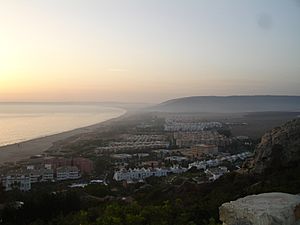
Zahara de los Atunes is located in the southern part of the Province of Cádiz. It sits on a flat area right by the sea. The village is surrounded by hills that are part of the Sierra del Retín and the Sierra de la Plata. As mentioned, it borders Tarifa to the south and Barbate to the north.
The weather in Zahara is a Mediterranean type, but with influences from the Atlantic Ocean. This means:
- Winters are mild, with temperatures usually above 10º Celsius (50º Fahrenheit).
- Summers are also mild, with average temperatures around 25º Celsius (77º Fahrenheit). It rarely gets hotter than 40º Celsius (104º Fahrenheit).
The area gets a good amount of rain, usually between 500 and 600 millimeters each year. It also gets a lot of sunshine, often more than 3000 hours a year! Because it's close to the Strait of Gibraltar, strong winds and storms are common, especially from autumn to spring.
The coastline of Zahara is about 1600 meters long. It stretches from the village all the way to Cabo de Plata (in Tarifa). This part of the coast is very natural and not too built up. The sea water here is very clear and clean.
See also
 In Spanish: Zahara de los Atunes para niños
 | Emma Amos |
 | Edward Mitchell Bannister |
 | Larry D. Alexander |
 | Ernie Barnes |


