
Tarifa facts for kids
Quick facts for kids
Tarifa
|
|||
|---|---|---|---|
 |
|||
|
|||

Tarifa
Location in Spain

Tarifa
Location in Province of Cádiz
|
|||
| Country | Spain | ||
| Autonomous community | Andalusia | ||
| Province | Cádiz | ||
| Judicial district | Algeciras | ||
| Area | |||
| • Total | 419.67 km2 (162.04 sq mi) | ||
| Elevation | 7 m (23 ft) | ||
| Population
(2018)
|
|||
| • Total | 18,169 | ||
| • Density | 43.2935/km2 (112.130/sq mi) | ||
| Demonym(s) | Tarifeños | ||
| Time zone | UTC+1 (CET) | ||
| • Summer (DST) | UTC+2 (CEST) | ||
| Postal code |
11380
|
||
| Dialing code | (+34) 956 | ||
| Official language(s) | Spanish | ||


Tarifa is a town in the province of Cádiz, Andalusia, Spain. It is located at the very southern tip of the Iberian Peninsula. Tarifa is famous worldwide for windsports like windsurfing and kitesurfing. The town is part of the Costa de la Luz (which means "coast of light"). It sits right across the Strait of Gibraltar, facing Morocco.
The municipality of Tarifa includes other small villages. These include Tahivilla, Facinas, and Bolonia.
Contents
History of Tarifa
Ancient Times and Roman Settlements
People once thought Tarifa was the Roman town of Julia Transducta. However, it is now believed that Julia Transducta was where Algeciras is today. There is strong evidence that the Roman settlement of Mellaria was located near Casas de Porro, Valdevaqueros, which is part of Tarifa.
The village of Bolonia, near Tarifa, was also a Roman town called Baelo Claudia. You can still see ancient Roman ruins there today.
The Name Tarifa
The name "Tarifa" comes from an Umayyad Caliphate military leader named Tarif ibn Malik. He arrived in the area in 710 AD.
Medieval Fortifications and Battles
After the Islamic conquest of southern Spain, Tarifa was fortified with strong walls starting in the 10th century. Over time, different groups controlled the town, including the taifa of Algeciras and the taifa of Seville. Later, the Almoravids took control.
In 1292, Sancho IV of Castile conquered Tarifa. Two years later, the town successfully defended itself against a siege by North African Islamic troops. Tarifa also survived another siege in 1340 by the Marinids, which led to the Battle of Río Salado.
Tarifa's Role in the Middle Ages
Even with its strong defenses, Tarifa did not have many people living there during the rest of the Middle Ages. After the destruction of Algeciras in 1369, Tarifa became the main base for the Castilian navy in the Strait of Gibraltar. This made the Admiral of Castile more powerful. Tarifa received many special rights from the Castilian kings. However, it was also often attacked by Muslim raids, which led to many deaths and kidnappings.
In the early 15th century, military activities were very important to Tarifa's society. The town was given to Fadrique Enríquez de Mendoza, the Admiral of Castile, in 1447. The people of Tarifa strongly opposed this.
Growth and Economy
After 1492, Tarifa became less important for military reasons. Because of its good pastures, raising animals became a big part of the economy. However, there wasn't much land for growing crops like cereals.
Fishing had been important to Tarifa since its conquest. By the early 16th century, a special way of fishing for tuna called almadraba had developed. The town's population grew in the 16th century, reaching about 3,500–4,000 people by 1587.
Modern History and Sieges
In 1514, Tarifa became the center of a marquisate, which also included Bornos, Espera, and Alcalá de los Gazules.
During the Peninsular War, French troops attacked Tarifa twice. They besieged the town on December 20, 1810, and again on December 18, 1811. In both cases, British troops from Gibraltar helped defend the town, as Spain and Britain were allies against the French.
During the 1811–12 Siege of Tarifa, about 3,000 troops defended the town, with 1,200 of them being British. Colonel Charles Holloway, a Royal Engineer, helped improve Tarifa's defenses.
On December 19, 1811, General Laval attacked the town again. He bombarded it over Christmas, demanding surrender on December 30. Both the British and Spanish commanders refused. Their bravery was rewarded when it started raining the next day. By January 5, the French realized their gunpowder was wet and their cannons were stuck in the mud, so they retreated.
Geography of Tarifa
Location and Southernmost Point

The Punta de Tarifa is the southernmost point of continental Europe. It is located at exactly 36 degrees latitude. Only a few European islands, like the Greek island of Gavdos, are farther south. Interestingly, the North African capitals of Algiers and Tunis are actually farther north than Tarifa!
Climate and Weather
Tarifa has a hot-summer Mediterranean climate. This means it has hot, dry summers and mild, wet winters. The nearby Atlantic Ocean greatly affects Tarifa's weather. This creates a very small change in temperature throughout the year.
For example, the average daily high temperature in August (the hottest month) is only about 9.3°C warmer than the average lowest temperature in January (the coldest month). This is much cooler than places further inland in the Guadalquivir valley. This makes Tarifa's weather very special.
Summers are much cooler than other coastal cities in Spain because of the cool Atlantic waters. Winters are also some of the mildest in continental Europe. Most rain falls during the winter, while summers are generally dry, which is typical for this type of climate.
| Climate data for Tarifa (1981-2010), extremes (1945-) | |||||||||||||
|---|---|---|---|---|---|---|---|---|---|---|---|---|---|
| Month | Jan | Feb | Mar | Apr | May | Jun | Jul | Aug | Sep | Oct | Nov | Dec | Year |
| Record high °C (°F) | 22.4 (72.3) |
24.7 (76.5) |
24.3 (75.7) |
26.7 (80.1) |
31.9 (89.4) |
34.9 (94.8) |
35.3 (95.5) |
37.0 (98.6) |
37.4 (99.3) |
31.8 (89.2) |
27.1 (80.8) |
23.6 (74.5) |
37.4 (99.3) |
| Mean daily maximum °C (°F) | 15.2 (59.4) |
15.1 (59.2) |
16.3 (61.3) |
17.3 (63.1) |
19.4 (66.9) |
21.8 (71.2) |
23.9 (75.0) |
24.5 (76.1) |
23.1 (73.6) |
20.6 (69.1) |
17.9 (64.2) |
16.1 (61.0) |
19.3 (66.7) |
| Daily mean °C (°F) | 13.0 (55.4) |
13.0 (55.4) |
14.4 (57.9) |
15.2 (59.4) |
17.2 (63.0) |
19.8 (67.6) |
21.7 (71.1) |
22.3 (72.1) |
21.1 (70.0) |
18.6 (65.5) |
15.9 (60.6) |
14.1 (57.4) |
17.2 (63.0) |
| Mean daily minimum °C (°F) | 10.8 (51.4) |
10.9 (51.6) |
12.4 (54.3) |
13.0 (55.4) |
14.9 (58.8) |
17.8 (64.0) |
19.4 (66.9) |
20.0 (68.0) |
19.0 (66.2) |
16.7 (62.1) |
13.9 (57.0) |
12.1 (53.8) |
15.1 (59.2) |
| Record low °C (°F) | −3.3 (26.1) |
−2.1 (28.2) |
1.2 (34.2) |
4.0 (39.2) |
7.4 (45.3) |
10.6 (51.1) |
11.9 (53.4) |
14.2 (57.6) |
5.0 (41.0) |
6.4 (43.5) |
2.4 (36.3) |
0.4 (32.7) |
−3.3 (26.1) |
| Average precipitation mm (inches) | 70 (2.8) |
75 (3.0) |
48 (1.9) |
57 (2.2) |
28 (1.1) |
8 (0.3) |
2 (0.1) |
4 (0.2) |
16 (0.6) |
80 (3.1) |
86 (3.4) |
118 (4.6) |
592 (23.3) |
| Average precipitation days (≥ 1 mm) | 7 | 8 | 5 | 7 | 4 | 1 | 0 | 0 | 2 | 6 | 8 | 10 | 58 |
| Average relative humidity (%) | 77 | 79 | 78 | 77 | 78 | 79 | 80 | 81 | 81 | 81 | 79 | 78 | 79 |
| Mean monthly sunshine hours | 153 | 161 | 199 | 218 | 264 | 284 | 307 | 297 | 233 | 202 | 170 | 142 | 2,630 |
| Source 1: Agencia Estatal de Meteorología | |||||||||||||
| Source 2: Agencia Estatal de Meteorología | |||||||||||||
Things to See and Do in Tarifa
.jpg)
.jpg)

Tarifa has many interesting historical sites and fun activities:
- Guzman Castle: This well-preserved castle is near the port. It was built around 960 AD by order of Caliph Abd-ar-Rahman III. Inside, you can find the Guzmán el Bueno Tower (from the 13th century) and the church of St. Mary, which was built on the site of an old mosque.
- Medieval Walls: You can still see parts of the old medieval walls that once protected the city. Out of three gates that used to exist, only the Puerta de Jerez (from the 13th century) remains today.
- Church of St. Matthew: This church was built in the early 16th century in a Gothic style. It was also built over a former mosque. The front of the church was changed in 1774.
- Roman City Ruins: The ruins of the ancient Roman city of Baelo Claudia are located close to Tarifa.
- Popular Summer Spot: Tarifa has become a very popular place for people from northern Europe to spend their summers.
Windsports and Nature
- Windsports Paradise: Tarifa's unique wind conditions make its beaches, like Playa de Los Lances, Valdevaqueros, and Punta Paloma, very popular for windsurfers and kitesurfers. The narrow Strait of Gibraltar acts like a funnel, creating a strong wind effect. This happens when either the Levante (an easterly wind from Africa) or the Poniente (a westerly wind from the Atlantic) blows. These two winds blow for over 300 days most years, meaning Tarifa has incredibly strong and steady winds all year round.
- Wind Turbines: Because of these strong winds, you will see many wind turbines dotted around Tarifa, generating clean energy.
- La Isla: This is a small island connected to the mainland by a 30-meter-long bridge. This island and its bridge are considered the official dividing line between the Atlantic and Mediterranean coasts of Andalusia.
- Bird and Whale Watching: Tarifa is located within the Intercontinental Mediterranean Biosphere Reserve. It's a famous place to watch migrating birds, especially storks, as they cross the Strait of Gibraltar in spring and autumn. You can also go whale and dolphin watching here. Several species live in the 14-kilometer-wide Strait, including the common dolphin, Pilot whale, sperm whale, and orca.
Tarifa in Culture
African Film Festival
Tarifa is known for its African Film Festival. The first festival took place in 2004.
Tarifa in Books
Tarifa is featured in the famous novel The Alchemist by Paulo Coelho.
Getting Around Tarifa

Ferry Services
There are regular ferry services that connect Tarifa with Tangier in Morocco (a 40-minute trip) and Ceuta (a 1-hour trip) from the ferry port.
Bus Services
You can find bus services from the bus station on Calle Batalla de Salado. There are regular buses between Tarifa and Algeciras, which is about 20 km northeast. Buses also go to Seville, about 200 km north. You can also find direct buses to Málaga and Cádiz. In the summer, a special kitesurfing bus runs along the A7 road between Tarifa bus station and Camping Jardin de las Dunas, stopping at popular hotels and campsites.
Taxi Services
There is a taxi stand on Avenida Andalucía. It's about a 5-minute walk from the bus station. It is located just outside the Puerto de Jerez, which is the main entrance to the old town.
Surroundings of Tarifa
The intentional community "Molino de Guadalmesi" is located about 13 km northeast of Tarifa. This community is part of the Global Ecovillage Network (GEN).
See also
 In Spanish: Tarifa para niños
Images for kids
-
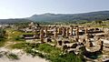
Ruins of Baelo Claudia near Bolonia Beach
-
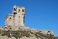
Castle of St Catalina.
.jpg)

