Zapallar facts for kids
Quick facts for kids
Zapallar
|
||||||
|---|---|---|---|---|---|---|
|
Town and Commune
|
||||||

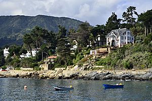
Coast of Zapallar
|
||||||
|
||||||
| Country | ||||||
| Region | ||||||
| Province | Petorca | |||||
| Government | ||||||
| • Type | Municipality | |||||
| Area | ||||||
| • Total | 288.0 km2 (111.2 sq mi) | |||||
| Elevation | 50 m (160 ft) | |||||
| Population
(2012 Census)
|
||||||
| • Total | 5,933 | |||||
| • Density | 20.601/km2 (53.356/sq mi) | |||||
| • Urban | 4,744 | |||||
| • Rural | 915 | |||||
| Sex | ||||||
| • Men | 2,914 | |||||
| • Women | 2,745 | |||||
| Time zone | UTC-4 (CLT) | |||||
| • Summer (DST) | UTC-3 (CLST) | |||||
| Area code(s) | 56 + 33 | |||||
| Climate | Csb | |||||
| Website | Municipality of Zapallar | |||||
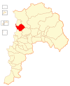
Zapallar is a town and a commune in Chile. It is located in the Petorca Province, which is part of the Valparaíso Region. Zapallar covers an area of 288 square kilometers (111 square miles). It is on the coast of the Pacific Ocean. The town is about 125 kilometers (78 miles) northwest of Santiago, Chile's capital city.
Contents
Understanding Zapallar's Population
This section looks at how many people live in Zapallar. It also shows how the population has changed over time.
Population Numbers and Growth
According to a census taken in 2002, Zapallar had 5,659 residents. This included 2,914 men and 2,745 women. Most people, about 83.8%, lived in urban areas (towns and cities). The remaining 16.2% lived in rural areas (the countryside). Between 1992 and 2002, Zapallar's population grew by 24.3%. This means 1,105 more people moved to the area.
How Zapallar is Governed
Zapallar is a commune, which is a local government area in Chile. It is managed by a group called a communal council.
Local Leadership
The council is led by an alcalde, who is like a mayor. The alcalde is chosen by the people in an election every four years. From 2012 to 2016, the alcalde was Nicolás Cox Urrejola. The communal council helps make decisions for the town.
Zapallar's Role in National Government
Zapallar is part of a larger area called Electoral District No. 6. This district sends people to the Chamber of Deputies, which is like one part of Chile's national parliament. Zapallar is also part of the VI Senate Circumscription (Valparaíso). This area sends people to the Senate, the other part of Chile's parliament. These elected officials represent the people of Zapallar and the surrounding areas in the national government.
Zapallar's Climate
Zapallar has a special type of weather. It is known for its mild temperatures and clear skies.
| Climate data for Zapallar | |||||||||||||
|---|---|---|---|---|---|---|---|---|---|---|---|---|---|
| Month | Jan | Feb | Mar | Apr | May | Jun | Jul | Aug | Sep | Oct | Nov | Dec | Year |
| Mean daily maximum °C (°F) | 22.6 (72.7) |
22.1 (71.8) |
19.2 (66.6) |
17.9 (64.2) |
16.0 (60.8) |
14.9 (58.8) |
14.1 (57.4) |
14.6 (58.3) |
15.6 (60.1) |
17.2 (63.0) |
19.4 (66.9) |
21.7 (71.1) |
17.9 (64.3) |
| Daily mean °C (°F) | 17.7 (63.9) |
17.6 (63.7) |
16.2 (61.2) |
14.1 (57.4) |
12.8 (55.0) |
11.9 (53.4) |
11.2 (52.2) |
11.5 (52.7) |
12.2 (54.0) |
13.4 (56.1) |
14.8 (58.6) |
16.6 (61.9) |
14.2 (57.5) |
| Mean daily minimum °C (°F) | 14.0 (57.2) |
14.1 (57.4) |
13.0 (55.4) |
11.1 (52.0) |
10.0 (50.0) |
9.2 (48.6) |
8.4 (47.1) |
8.5 (47.3) |
9.2 (48.6) |
10.2 (50.4) |
11.2 (52.2) |
12.6 (54.7) |
11.0 (51.7) |
| Average precipitation mm (inches) | 3.1 (0.12) |
0.9 (0.04) |
1.4 (0.06) |
13.5 (0.53) |
71.8 (2.83) |
120.5 (4.74) |
76.1 (3.00) |
54.2 (2.13) |
28.8 (1.13) |
9.9 (0.39) |
2.5 (0.10) |
1.6 (0.06) |
384.3 (15.13) |
| Average relative humidity (%) | 80 | 80 | 83 | 85 | 86 | 86 | 85 | 84 | 84 | 82 | 80 | 78 | 83 |
| Source: Bioclimatografia de Chile | |||||||||||||
Zapallar has a warm-summer Mediterranean climate. This means it has warm, dry summers and mild, wet winters. The average temperature in the warmest month (January) is about 17.7°C (63.9°F). In the coolest month (July), the average temperature is around 11.2°C (52.2°F). Most of the rain falls during the winter months, especially in June and July. The air is often humid, especially in the cooler months.
See also
 In Spanish: Zapallar para niños
 | Georgia Louise Harris Brown |
 | Julian Abele |
 | Norma Merrick Sklarek |
 | William Sidney Pittman |


