
Zion – Mount Carmel Highway facts for kids
Quick facts for kids |
|
|
Zion – Mount Carmel Highway
|
|

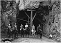
The east portal of the Zion-Mt. Carmel Tunnel, September 1929
|
|

Location in Utah

Location in the United States
|
|
| Location | Between South Entrance of Zion National Park (on the border with Springdale |
|---|---|
| Nearest city | Springdale |
| Built | 1930 |
| Architect | MacDonald,Thomas; Et. al |
| MPS | Zion National Park MRA |
| NRHP reference No. | 86003709 |
| Added to NRHP | July 07, 1987 |
The Zion – Mount Carmel Highway is a special road, about 25 miles (40 km) long, located in southern Utah, United States. It's so important that it's listed on the National Register of Historic Places, which means it's a historic landmark.
Contents
What is the Zion-Mount Carmel Highway?
This highway is the eastern part of Utah State Route 9. It starts near Springdale and goes east into Zion National Park. Along the way, it passes through the amazing Zion-Mount Carmel Tunnel, which is about 1.1 miles (1.8 km) long.
After leaving the park, the highway continues east. It ends at U.S. Route 89 in a place called Mount Carmel Junction. This road helps connect many famous national parks and monuments. It is part of a loop tour that includes Zion, Bryce Canyon National Park, Cedar Breaks National Monument, and the North Rim of Grand Canyon National Park.
How Was the Highway Built?
The idea for this road came about in 1923. Experts like B.J. Finch and Howard C. Means, along with local rancher John Winder, explored possible routes. The National Park Service looked at different paths. They chose the route through Pine Creek Canyon. This path meant they would have to build a tunnel through a huge rock formation called the Great Arch.
The US Bureau of Public Roads drew up the detailed plans for the road. The National Park Service helped design the bridges, walls, and other parts. Work on the 25-mile (40 km) road began in 1927. It was finished in 1930.
Building the Zion-Mount Carmel Tunnel
The tunnel is a very important part of the highway. It is about 5,613 feet (1,711 meters) long. It follows the shape of the Pine Creek Canyon wall. The tunnel's entrance on the west side has a beautiful stone front. The east entrance is a natural opening in the rock, right after a bridge.
Builders used mining methods to dig the tunnel. They started from inside the rock and worked their way out. The tunnel has special openings called "galleries." These galleries let in light and fresh air from outside the canyon. They also helped the workers get rid of the rock they dug out. They simply dumped it through the openings into the canyon below.
Originally, you could park at these galleries to enjoy the views. But this was stopped because it wasn't safe. Some galleries have been fixed with concrete because of rockslides. Inside the tunnel, you can see the natural rock walls. Some parts have concrete to make them stronger.
Tunnel Facts
The Nevada Construction Company started building the tunnel in 1927. It was finished in 1930. The cost was about $503,000, which would be millions of dollars today. When it was completed, it was the longest road tunnel outside of a city in the United States.
Because the tunnel is narrow, large vehicles need special permission to go through. Vehicles taller than 11.33 feet (3.45 meters) or wider than 7.83 feet (2.39 meters) must give notice. This allows the park to stop traffic from the other direction. This way, the large vehicle can drive down the middle of the tunnel. Very tall vehicles (over 13.08 feet or 3.99 meters), big trucks, bicycles, and people walking are not allowed in the tunnel.
Other important structures on the highway include the Pine Creek Bridge and the Virgin River Bridge. There is also a second, shorter tunnel through a rock spur east of the main tunnel.
The Zion – Mount Carmel Highway was added to the National Register of Historic Places on July 7, 1987.
Images for kids
-

The west end of the Pine Creek Bridge and the east portal of the Zion-Mt. Carmel Tunnel, around 2006.
-
A horseback party at the western entrance to the Zion-Mt. Carmel Tunnel in September 1929. The tunnel made the trip from Zion National Park to Bryce Canyon National Park 70 miles (110 km) shorter.


